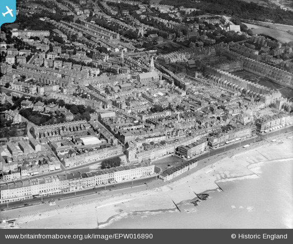
EPW016890 ENGLAND (1926). Christ Church and environs, Hastings, 1926
© Hawlfraint cyfranwyr OpenStreetMap a thrwyddedwyd gan yr OpenStreetMap Foundation. 2025. Trwyddedir y gartograffeg fel CC BY-SA.
Delweddau cyfagos (8)
Manylion
| Pennawd | [EPW016890] Christ Church and environs, Hastings, 1926 |
| Cyfeirnod | EPW016890 |
| Dyddiad | August-1926 |
| Dolen | |
| Enw lle | HASTINGS |
| Plwyf | |
| Ardal | |
| Gwlad | ENGLAND |
| Dwyreiniad / Gogleddiad | 580173, 108995 |
| Hydred / Lledred | 0.5599519488049, 50.851811814804 |
| Cyfeirnod Grid Cenedlaethol | TQ802090 |
Pinnau
 John W |
Thursday 4th of May 2017 06:29:08 PM | |
 Class31 |
Saturday 6th of October 2012 04:32:51 PM | |
 Class31 |
Saturday 6th of October 2012 04:31:19 PM | |
 Class31 |
Saturday 6th of October 2012 04:30:15 PM | |
 Class31 |
Saturday 6th of October 2012 04:29:51 PM | |
 Class31 |
Saturday 6th of October 2012 04:28:56 PM | |
 Class31 |
Saturday 6th of October 2012 04:28:16 PM | |
 Class31 |
Saturday 6th of October 2012 04:27:12 PM | |
 Class31 |
Saturday 6th of October 2012 04:25:39 PM | |
 Class31 |
Saturday 6th of October 2012 04:24:47 PM | |
 Class31 |
Saturday 6th of October 2012 04:24:17 PM | |
 Class31 |
Saturday 6th of October 2012 04:21:37 PM | |
 Class31 |
Saturday 6th of October 2012 04:19:26 PM |


![[EPW016890] Christ Church and environs, Hastings, 1926](http://britainfromabove.org.uk/sites/all/libraries/aerofilms-images/public/100x100/EPW/016/EPW016890.jpg)
![[EAW002415] The seafront and town from Marine Court to London Road, Hastings, from the south-east, 1946](http://britainfromabove.org.uk/sites/all/libraries/aerofilms-images/public/100x100/EAW/002/EAW002415.jpg)
![[EPW000114] General View, Hastings, from the south-west, 1920](http://britainfromabove.org.uk/sites/all/libraries/aerofilms-images/public/100x100/EPW/000/EPW000114.jpg)
![[EPW035344] The Promendae and environs, Hastings, from the south-west, 1931](http://britainfromabove.org.uk/sites/all/libraries/aerofilms-images/public/100x100/EPW/035/EPW035344.jpg)
![[EPW000117] Old London Road Area, Hastings, from the south-east, 1920](http://britainfromabove.org.uk/sites/all/libraries/aerofilms-images/public/100x100/EPW/000/EPW000117.jpg)
![[EAW002414] The seafront and town at Grand Parade to the west of Warrior Square, Hastings, from the south-east, 1946](http://britainfromabove.org.uk/sites/all/libraries/aerofilms-images/public/100x100/EAW/002/EAW002414.jpg)
![[EPW026208] Christ Church, Warrior Square and environs, Hastings, 1929](http://britainfromabove.org.uk/sites/all/libraries/aerofilms-images/public/100x100/EPW/026/EPW026208.jpg)
![[EPW042841] Marina, Palace Pier Pavilion and the town, St Leonards, from the east, 1933](http://britainfromabove.org.uk/sites/all/libraries/aerofilms-images/public/100x100/EPW/042/EPW042841.jpg)