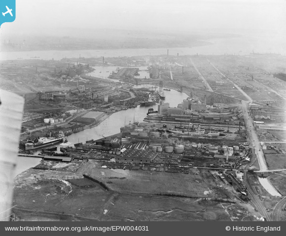
EPW004031 ENGLAND (1920). The West Float and River Mersey, Birkenhead, from the north-west, 1920
© Hawlfraint cyfranwyr OpenStreetMap a thrwyddedwyd gan yr OpenStreetMap Foundation. 2025. Trwyddedir y gartograffeg fel CC BY-SA.
Delweddau cyfagos (12)
Manylion
| Pennawd | [EPW004031] The West Float and River Mersey, Birkenhead, from the north-west, 1920 |
| Cyfeirnod | EPW004031 |
| Dyddiad | July-1920 |
| Dolen | |
| Enw lle | BIRKENHEAD |
| Plwyf | |
| Ardal | |
| Gwlad | ENGLAND |
| Dwyreiniad / Gogleddiad | 329879, 390705 |
| Hydred / Lledred | -3.0549561499631, 53.408234631493 |
| Cyfeirnod Grid Cenedlaethol | SJ299907 |
Pinnau
 XMAS DAY |
Monday 17th of June 2024 03:47:01 PM | |
 XMAS DAY |
Tuesday 25th of July 2023 05:19:53 PM | |
 XMAS DAY |
Tuesday 25th of July 2023 05:16:21 PM | |
 XMAS DAY |
Tuesday 25th of July 2023 05:13:00 PM | |
 MB |
Tuesday 20th of September 2016 09:20:47 AM | |
 MB |
Tuesday 20th of September 2016 09:06:10 AM | |
Built in 1913 for Joseph Rank |
 MB |
Tuesday 20th of September 2016 09:08:03 AM |
 Pete65 |
Saturday 26th of July 2014 04:24:56 PM | |
 Pete65 |
Saturday 26th of July 2014 04:23:02 PM | |
 Pete65 |
Saturday 26th of July 2014 04:20:36 PM |


![[EPW004031] The West Float and River Mersey, Birkenhead, from the north-west, 1920](http://britainfromabove.org.uk/sites/all/libraries/aerofilms-images/public/100x100/EPW/004/EPW004031.jpg)
![[EPW053315] Bidston Dock and the West Float Graving Docks, Bidston, 1937](http://britainfromabove.org.uk/sites/all/libraries/aerofilms-images/public/100x100/EPW/053/EPW053315.jpg)
![[EPW018914] The Anglo-American Oil Company Depot and environs, Bidston, 1927](http://britainfromabove.org.uk/sites/all/libraries/aerofilms-images/public/100x100/EPW/018/EPW018914.jpg)
![[EPW011217] Vacuum Oil and Grease Works alongside Poulton Bridge, Birkenhead, 1924. This image has been produced from a damaged print affected by flare.](http://britainfromabove.org.uk/sites/all/libraries/aerofilms-images/public/100x100/EPW/011/EPW011217.jpg)
![[EPW018916] The Anglo-American Oil Company Depot and environs, Bidston, 1927](http://britainfromabove.org.uk/sites/all/libraries/aerofilms-images/public/100x100/EPW/018/EPW018916.jpg)
![[EPW018915] The Anglo-American Oil Company Depot and environs, Bidston, 1927](http://britainfromabove.org.uk/sites/all/libraries/aerofilms-images/public/100x100/EPW/018/EPW018915.jpg)
![[EPW013690] The Vacuum Oil Company Works, Birkenhead, 1925](http://britainfromabove.org.uk/sites/all/libraries/aerofilms-images/public/100x100/EPW/013/EPW013690.jpg)
![[EPW013692] The Vacuum Oil Company Works, Birkenhead, 1925. This image has been produced from a print.](http://britainfromabove.org.uk/sites/all/libraries/aerofilms-images/public/100x100/EPW/013/EPW013692.jpg)
![[EPW013693] The Vacuum Oil Company Works, Birkenhead, 1925](http://britainfromabove.org.uk/sites/all/libraries/aerofilms-images/public/100x100/EPW/013/EPW013693.jpg)
![[EPW018917] The Anglo-American Oil Company Depot and environs, Bidston, 1927](http://britainfromabove.org.uk/sites/all/libraries/aerofilms-images/public/100x100/EPW/018/EPW018917.jpg)
![[EPW053313] Bidston Dock and the West Float, Bidston, 1937](http://britainfromabove.org.uk/sites/all/libraries/aerofilms-images/public/100x100/EPW/053/EPW053313.jpg)
![[EPW013691] The Vacuum Oil Company Works, Birkenhead, 1925](http://britainfromabove.org.uk/sites/all/libraries/aerofilms-images/public/100x100/EPW/013/EPW013691.jpg)