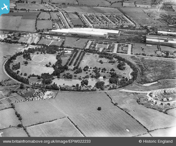
EPW022233 ENGLAND (1928). Queen's Park and the Crewe Works, Crewe, 1928
© Hawlfraint cyfranwyr OpenStreetMap a thrwyddedwyd gan yr OpenStreetMap Foundation. 2024. Trwyddedir y gartograffeg fel CC BY-SA.
Delweddau cyfagos (13)
Manylion
| Pennawd | [EPW022233] Queen's Park and the Crewe Works, Crewe, 1928 |
| Cyfeirnod | EPW022233 |
| Dyddiad | 31-July-1928 |
| Dolen | |
| Enw lle | CREWE |
| Plwyf | |
| Ardal | |
| Gwlad | ENGLAND |
| Dwyreiniad / Gogleddiad | 368793, 355610 |
| Hydred / Lledred | -2.4660960178886, 53.0964836443 |
| Cyfeirnod Grid Cenedlaethol | SJ688556 |
Pinnau
 Crewedaddy |
Wednesday 13th of September 2017 12:23:18 AM | |
 MB |
Sunday 4th of November 2012 06:15:08 PM | |
 MB |
Sunday 4th of November 2012 06:14:38 PM | |
It is a bandstand - see http://www.geograph.org.uk/photo/4579486 for a close-up. |
 John W |
Monday 1st of August 2016 05:01:47 PM |
Cyfraniadau Grŵp
The park was opened in the summer of 1888 by the Duke of Cambridge |
 MB |
Sunday 4th of November 2012 06:16:45 PM |
This is facing North. The Bentley works (formerly Rolls Royce) at Pym's Lane now occupies most of the area bounded by the north/south line of trees (still there) at the bridge on the western tip of the works (still there) and Pym's Lane running East/West along the top of the photo. My first home in Crewe was on the western edge of that bare field opposite the park gates at the end of that double avenue of trees (cut down and replaced about 2006). Immediately to the West is the Webb Orphanage (building still there and currently empty). |
 Crewedaddy |
Monday 25th of June 2012 11:44:30 PM |


![[EPW022233] Queen's Park and the Crewe Works, Crewe, 1928](http://britainfromabove.org.uk/sites/all/libraries/aerofilms-images/public/100x100/EPW/022/EPW022233.jpg)
![[EPW023572] Queen's Park, Crewe, 1928](http://britainfromabove.org.uk/sites/all/libraries/aerofilms-images/public/100x100/EPW/023/EPW023572.jpg)
![[EPW022236] Queen's Park and the Crewe Works, Crewe, 1928](http://britainfromabove.org.uk/sites/all/libraries/aerofilms-images/public/100x100/EPW/022/EPW022236.jpg)
![[EPW022232] Queen's Park and the Crewe Works, Crewe, 1928](http://britainfromabove.org.uk/sites/all/libraries/aerofilms-images/public/100x100/EPW/022/EPW022232.jpg)
![[EPW022231] Queen's Park, Crewe, 1928](http://britainfromabove.org.uk/sites/all/libraries/aerofilms-images/public/100x100/EPW/022/EPW022231.jpg)
![[EPW023574] Queen's Park, Crewe, 1928](http://britainfromabove.org.uk/sites/all/libraries/aerofilms-images/public/100x100/EPW/023/EPW023574.jpg)
![[EPW023576] Queen's Park, Crewe, 1928](http://britainfromabove.org.uk/sites/all/libraries/aerofilms-images/public/100x100/EPW/023/EPW023576.jpg)
![[EPW023573] Queen's Park, Crewe, 1928](http://britainfromabove.org.uk/sites/all/libraries/aerofilms-images/public/100x100/EPW/023/EPW023573.jpg)
![[EPW022235] Queen's Park and the Crewe Works, Crewe, 1928](http://britainfromabove.org.uk/sites/all/libraries/aerofilms-images/public/100x100/EPW/022/EPW022235.jpg)
![[EPW022238] Queen's Park, Crewe, 1928](http://britainfromabove.org.uk/sites/all/libraries/aerofilms-images/public/100x100/EPW/022/EPW022238.jpg)
![[EPW023575] Queen's Park, Crewe, 1928](http://britainfromabove.org.uk/sites/all/libraries/aerofilms-images/public/100x100/EPW/023/EPW023575.jpg)
![[EPW022234] Queen's Park and environs, Crewe, 1928](http://britainfromabove.org.uk/sites/all/libraries/aerofilms-images/public/100x100/EPW/022/EPW022234.jpg)
![[EPW022237] Queen's Park, Crewe, 1928](http://britainfromabove.org.uk/sites/all/libraries/aerofilms-images/public/100x100/EPW/022/EPW022237.jpg)