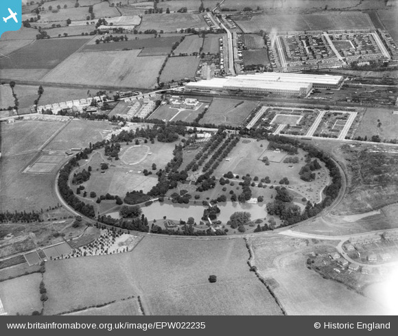
EPW022235 ENGLAND (1928). Queen's Park and the Crewe Works, Crewe, 1928
© Hawlfraint cyfranwyr OpenStreetMap a thrwyddedwyd gan yr OpenStreetMap Foundation. 2024. Trwyddedir y gartograffeg fel CC BY-SA.
Delweddau cyfagos (13)
Manylion
| Pennawd | [EPW022235] Queen's Park and the Crewe Works, Crewe, 1928 |
| Cyfeirnod | EPW022235 |
| Dyddiad | 31-July-1928 |
| Dolen | |
| Enw lle | CREWE |
| Plwyf | |
| Ardal | |
| Gwlad | ENGLAND |
| Dwyreiniad / Gogleddiad | 368735, 355700 |
| Hydred / Lledred | -2.4669710131311, 53.097289328759 |
| Cyfeirnod Grid Cenedlaethol | SJ687557 |
Pinnau
 Crewedaddy |
Saturday 7th of June 2014 12:38:20 AM | |
 Crewedaddy |
Saturday 7th of June 2014 12:36:21 AM | |
 Crewedaddy |
Saturday 7th of June 2014 12:34:59 AM |


![[EPW022235] Queen's Park and the Crewe Works, Crewe, 1928](http://britainfromabove.org.uk/sites/all/libraries/aerofilms-images/public/100x100/EPW/022/EPW022235.jpg)
![[EPW023574] Queen's Park, Crewe, 1928](http://britainfromabove.org.uk/sites/all/libraries/aerofilms-images/public/100x100/EPW/023/EPW023574.jpg)
![[EPW022232] Queen's Park and the Crewe Works, Crewe, 1928](http://britainfromabove.org.uk/sites/all/libraries/aerofilms-images/public/100x100/EPW/022/EPW022232.jpg)
![[EPW023576] Queen's Park, Crewe, 1928](http://britainfromabove.org.uk/sites/all/libraries/aerofilms-images/public/100x100/EPW/023/EPW023576.jpg)
![[EPW022238] Queen's Park, Crewe, 1928](http://britainfromabove.org.uk/sites/all/libraries/aerofilms-images/public/100x100/EPW/022/EPW022238.jpg)
![[EPW023575] Queen's Park, Crewe, 1928](http://britainfromabove.org.uk/sites/all/libraries/aerofilms-images/public/100x100/EPW/023/EPW023575.jpg)
![[EPW022237] Queen's Park, Crewe, 1928](http://britainfromabove.org.uk/sites/all/libraries/aerofilms-images/public/100x100/EPW/022/EPW022237.jpg)
![[EPW022234] Queen's Park and environs, Crewe, 1928](http://britainfromabove.org.uk/sites/all/libraries/aerofilms-images/public/100x100/EPW/022/EPW022234.jpg)
![[EPW022233] Queen's Park and the Crewe Works, Crewe, 1928](http://britainfromabove.org.uk/sites/all/libraries/aerofilms-images/public/100x100/EPW/022/EPW022233.jpg)
![[EPW023572] Queen's Park, Crewe, 1928](http://britainfromabove.org.uk/sites/all/libraries/aerofilms-images/public/100x100/EPW/023/EPW023572.jpg)
![[EPW023573] Queen's Park, Crewe, 1928](http://britainfromabove.org.uk/sites/all/libraries/aerofilms-images/public/100x100/EPW/023/EPW023573.jpg)
![[EPW022236] Queen's Park and the Crewe Works, Crewe, 1928](http://britainfromabove.org.uk/sites/all/libraries/aerofilms-images/public/100x100/EPW/022/EPW022236.jpg)
![[EPW022231] Queen's Park, Crewe, 1928](http://britainfromabove.org.uk/sites/all/libraries/aerofilms-images/public/100x100/EPW/022/EPW022231.jpg)