
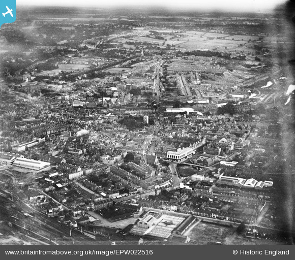
EPW022516 ENGLAND (1928). St Mary's Church and the town centre, Reading, from the north-west, 1928
© Hawlfraint cyfranwyr OpenStreetMap a thrwyddedwyd gan yr OpenStreetMap Foundation. 2025. Trwyddedir y gartograffeg fel CC BY-SA.
Delweddau cyfagos (4)
EPW022516

EAW034975

EPW022700

EPW000864

Manylion
| Pennawd | [EPW022516] St Mary's Church and the town centre, Reading, from the north-west, 1928 |
| Cyfeirnod | EPW022516 |
| Dyddiad | 11-August-1928 |
| Dolen | |
| Enw lle | READING |
| Plwyf | |
| Ardal | |
| Gwlad | ENGLAND |
| Dwyreiniad / Gogleddiad | 471219, 173584 |
| Hydred / Lledred | -0.97484828537193, 51.456261537141 |
| Cyfeirnod Grid Cenedlaethol | SU712736 |
Pinnau
 Norman W |
Tuesday 2nd of October 2012 02:15:59 PM | |
Norman W |
Tuesday 2nd of October 2012 02:13:26 PM | |
Norman W |
Saturday 29th of September 2012 10:54:19 PM | |
Norman W |
Saturday 29th of September 2012 10:53:00 PM | |
Norman W |
Saturday 29th of September 2012 10:50:49 PM | |
Norman W |
Saturday 29th of September 2012 10:49:03 PM | |
Norman W |
Saturday 29th of September 2012 10:47:01 PM | |
Norman W |
Thursday 27th of September 2012 06:13:01 PM | |
Norman W |
Thursday 27th of September 2012 06:03:51 PM | |
Norman W |
Thursday 27th of September 2012 06:02:23 PM |