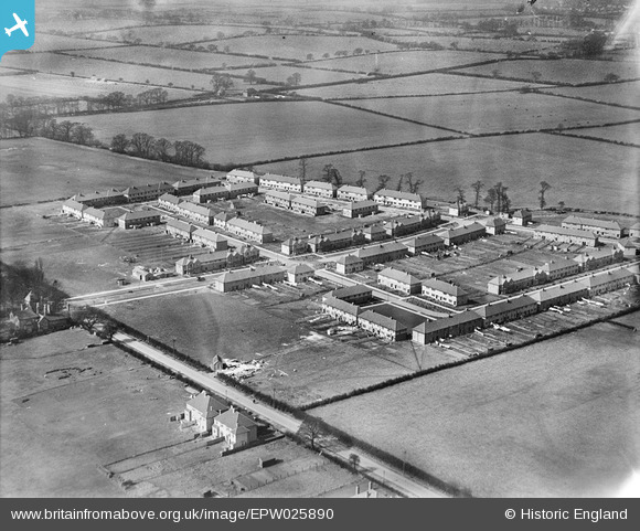
EPW025890 ENGLAND (1929). New housing off Eastcote Lane, South Harrow, 1929
© Hawlfraint cyfranwyr OpenStreetMap a thrwyddedwyd gan yr OpenStreetMap Foundation. 2024. Trwyddedir y gartograffeg fel CC BY-SA.
Delweddau cyfagos (7)
Manylion
| Pennawd | [EPW025890] New housing off Eastcote Lane, South Harrow, 1929 |
| Cyfeirnod | EPW025890 |
| Dyddiad | March-1929 |
| Dolen | |
| Enw lle | SOUTH HARROW |
| Plwyf | |
| Ardal | |
| Gwlad | ENGLAND |
| Dwyreiniad / Gogleddiad | 512836, 186167 |
| Hydred / Lledred | -0.37198247925351, 51.562602503987 |
| Cyfeirnod Grid Cenedlaethol | TQ128862 |
Pinnau
 PaulN |
Sunday 29th of May 2022 10:07:19 PM | |
 Class31 |
Saturday 5th of January 2013 09:26:11 AM | |
 Class31 |
Saturday 5th of January 2013 09:25:49 AM | |
 Class31 |
Saturday 5th of January 2013 09:25:23 AM | |
 Class31 |
Saturday 5th of January 2013 09:25:04 AM | |
 roxeth |
Sunday 7th of October 2012 09:37:12 AM | |
 roxeth |
Sunday 7th of October 2012 09:36:09 AM | |
 Ron B |
Sunday 9th of September 2012 10:23:54 AM | |
 Ron B |
Sunday 9th of September 2012 10:16:37 AM | |
 Ron B |
Sunday 9th of September 2012 10:15:17 AM |


![[EPW025890] New housing off Eastcote Lane, South Harrow, 1929](http://britainfromabove.org.uk/sites/all/libraries/aerofilms-images/public/100x100/EPW/025/EPW025890.jpg)
![[EPW025891] New housing off Eastcote Lane, South Harrow, 1929](http://britainfromabove.org.uk/sites/all/libraries/aerofilms-images/public/100x100/EPW/025/EPW025891.jpg)
![[EPW057960] The area around Eastcote Lane, South Harrow, 1938. This image has been produced from a copy-negative.](http://britainfromabove.org.uk/sites/all/libraries/aerofilms-images/public/100x100/EPW/057/EPW057960.jpg)
![[EPW025888] New housing off Eastcote Lane, South Harrow, 1929](http://britainfromabove.org.uk/sites/all/libraries/aerofilms-images/public/100x100/EPW/025/EPW025888.jpg)
![[EPW025889] New housing off Eastcote Lane, South Harrow, 1929](http://britainfromabove.org.uk/sites/all/libraries/aerofilms-images/public/100x100/EPW/025/EPW025889.jpg)
![[EPW040812] Eastcote Lane, Stuart Avenue and environs, South Harrow, from the south-west, 1933](http://britainfromabove.org.uk/sites/all/libraries/aerofilms-images/public/100x100/EPW/040/EPW040812.jpg)
![[EPW040815] Eastcote Lane, Rosebery Avenue and environs, South Harrow, from the south-west, 1933](http://britainfromabove.org.uk/sites/all/libraries/aerofilms-images/public/100x100/EPW/040/EPW040815.jpg)