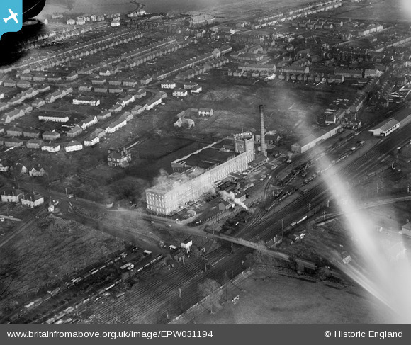
EPW031194 ENGLAND (1929). The Horlicks Malted Milk Factory and environs, Slough, 1929
© Hawlfraint cyfranwyr OpenStreetMap a thrwyddedwyd gan yr OpenStreetMap Foundation. 2024. Trwyddedir y gartograffeg fel CC BY-SA.
Delweddau cyfagos (27)
Manylion
| Pennawd | [EPW031194] The Horlicks Malted Milk Factory and environs, Slough, 1929 |
| Cyfeirnod | EPW031194 |
| Dyddiad | 21-November-1929 |
| Dolen | |
| Enw lle | SLOUGH |
| Plwyf | |
| Ardal | |
| Gwlad | ENGLAND |
| Dwyreiniad / Gogleddiad | 497279, 180412 |
| Hydred / Lledred | -0.59795423023277, 51.513765242152 |
| Cyfeirnod Grid Cenedlaethol | SU973804 |
Pinnau
 Class31 |
Wednesday 3rd of July 2013 09:04:50 PM | |
 Class31 |
Wednesday 3rd of July 2013 08:50:48 PM | |
 Class31 |
Wednesday 3rd of July 2013 07:53:56 PM | |
 Class31 |
Wednesday 3rd of July 2013 07:04:32 PM | |
 Class31 |
Wednesday 3rd of July 2013 06:55:53 PM | |
 Class31 |
Wednesday 3rd of July 2013 06:44:55 PM |


![[EPW031194] The Horlicks Malted Milk Factory and environs, Slough, 1929](http://britainfromabove.org.uk/sites/all/libraries/aerofilms-images/public/100x100/EPW/031/EPW031194.jpg)
![[EPW031196] The Horlicks Malted Milk Factory and environs, Slough, 1929](http://britainfromabove.org.uk/sites/all/libraries/aerofilms-images/public/100x100/EPW/031/EPW031196.jpg)
![[EPW031193] The Horlicks Malted Milk Factory, Slough, 1929](http://britainfromabove.org.uk/sites/all/libraries/aerofilms-images/public/100x100/EPW/031/EPW031193.jpg)
![[EPW021891] Horlicks Malted Milk Factory, Slough, 1928](http://britainfromabove.org.uk/sites/all/libraries/aerofilms-images/public/100x100/EPW/021/EPW021891.jpg)
![[EPW021892] Horlicks Malted Milk Factory, Slough, 1928](http://britainfromabove.org.uk/sites/all/libraries/aerofilms-images/public/100x100/EPW/021/EPW021892.jpg)
![[EPW031197] The Horlicks Malted Milk Factory and environs, Slough, 1929](http://britainfromabove.org.uk/sites/all/libraries/aerofilms-images/public/100x100/EPW/031/EPW031197.jpg)
![[EPW008010] The Horlicks Malted Milk Co Factory, Slough, 1922. This image has been produced from a copy-negative.](http://britainfromabove.org.uk/sites/all/libraries/aerofilms-images/public/100x100/EPW/008/EPW008010.jpg)
![[EPW021789] Horlicks Malted Milk Factory, Slough, 1928](http://britainfromabove.org.uk/sites/all/libraries/aerofilms-images/public/100x100/EPW/021/EPW021789.jpg)
![[EPW031198] The Horlicks Malted Milk Factory and environs, Slough, 1929](http://britainfromabove.org.uk/sites/all/libraries/aerofilms-images/public/100x100/EPW/031/EPW031198.jpg)
![[EPW031195] The Horlicks Malted Milk Factory and environs, Slough, 1929](http://britainfromabove.org.uk/sites/all/libraries/aerofilms-images/public/100x100/EPW/031/EPW031195.jpg)
![[EPW021893] Horlicks Malted Milk Factory, Slough, 1928](http://britainfromabove.org.uk/sites/all/libraries/aerofilms-images/public/100x100/EPW/021/EPW021893.jpg)
![[EPW021790] Horlicks Malted Milk Factory and surroundings, Slough, 1928](http://britainfromabove.org.uk/sites/all/libraries/aerofilms-images/public/100x100/EPW/021/EPW021790.jpg)
![[EPW021896] Horlicks Malted Milk Factory, Slough, 1928](http://britainfromabove.org.uk/sites/all/libraries/aerofilms-images/public/100x100/EPW/021/EPW021896.jpg)
![[EPW031607] Horlick's Malted Milk Co Ltd Malted Milk Factory, Slough, 1930](http://britainfromabove.org.uk/sites/all/libraries/aerofilms-images/public/100x100/EPW/031/EPW031607.jpg)
![[EPW021787] Horlicks Malted Milk Factory, Slough, 1928](http://britainfromabove.org.uk/sites/all/libraries/aerofilms-images/public/100x100/EPW/021/EPW021787.jpg)
![[EPW021889] Horlicks Malted Milk Factory, Slough, 1928](http://britainfromabove.org.uk/sites/all/libraries/aerofilms-images/public/100x100/EPW/021/EPW021889.jpg)
![[EPW021788] Horlicks Malted Milk Factory, Slough, 1928](http://britainfromabove.org.uk/sites/all/libraries/aerofilms-images/public/100x100/EPW/021/EPW021788.jpg)
![[EPW021894] Horlicks Malted Milk Factory, Slough, 1928](http://britainfromabove.org.uk/sites/all/libraries/aerofilms-images/public/100x100/EPW/021/EPW021894.jpg)
![[EPW021785] Horlicks Malted Milk Factory, Slough, 1928](http://britainfromabove.org.uk/sites/all/libraries/aerofilms-images/public/100x100/EPW/021/EPW021785.jpg)
![[EPW021895] Horlicks Malted Milk Factory, Slough, 1928](http://britainfromabove.org.uk/sites/all/libraries/aerofilms-images/public/100x100/EPW/021/EPW021895.jpg)
![[EPW031606] Horlick's Malted Milk Co Ltd Malted Milk Factory, Slough, 1930](http://britainfromabove.org.uk/sites/all/libraries/aerofilms-images/public/100x100/EPW/031/EPW031606.jpg)
![[EPW031608] Horlick's Malted Milk Co Ltd Malted Milk Factory, Slough, 1930](http://britainfromabove.org.uk/sites/all/libraries/aerofilms-images/public/100x100/EPW/031/EPW031608.jpg)
![[EPW021890] Horlicks Malted Milk Factory, Slough, 1928](http://britainfromabove.org.uk/sites/all/libraries/aerofilms-images/public/100x100/EPW/021/EPW021890.jpg)
![[EPW021786] Horlicks Malted Milk Factory, Slough, 1928](http://britainfromabove.org.uk/sites/all/libraries/aerofilms-images/public/100x100/EPW/021/EPW021786.jpg)
![[EPW021888] Horlicks Malted Milk Factory, Slough, 1928](http://britainfromabove.org.uk/sites/all/libraries/aerofilms-images/public/100x100/EPW/021/EPW021888.jpg)
![[EPW031603] Horlick's Malted Milk Co Ltd Malted Milk Factory, Slough, 1930](http://britainfromabove.org.uk/sites/all/libraries/aerofilms-images/public/100x100/EPW/031/EPW031603.jpg)
![[EPW051468] The Horlicks Factory and surrounding housing development, Slough, 1936](http://britainfromabove.org.uk/sites/all/libraries/aerofilms-images/public/100x100/EPW/051/EPW051468.jpg)
