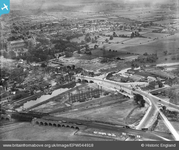
EPW044918 ENGLAND (1934). London Road Bridge, the River Nene and environs, Peterborough, 1934
© Hawlfraint cyfranwyr OpenStreetMap a thrwyddedwyd gan yr OpenStreetMap Foundation. 2025. Trwyddedir y gartograffeg fel CC BY-SA.
Delweddau cyfagos (28)
Manylion
| Pennawd | [EPW044918] London Road Bridge, the River Nene and environs, Peterborough, 1934 |
| Cyfeirnod | EPW044918 |
| Dyddiad | June-1934 |
| Dolen | |
| Enw lle | PETERBOROUGH |
| Plwyf | |
| Ardal | |
| Gwlad | ENGLAND |
| Dwyreiniad / Gogleddiad | 519315, 298196 |
| Hydred / Lledred | -0.23938136256925, 52.568128065046 |
| Cyfeirnod Grid Cenedlaethol | TL193982 |
Pinnau
Cyfraniadau Grŵp
Bridge over the River Nene, Peterborough , 10/06/2014 |
 Class31 |
Wednesday 11th of June 2014 08:36:56 PM |


![[EPW044918] London Road Bridge, the River Nene and environs, Peterborough, 1934](http://britainfromabove.org.uk/sites/all/libraries/aerofilms-images/public/100x100/EPW/044/EPW044918.jpg)
![[EPW044921] London Road Bridge, Broad Bridge Street and environs, Peterborough, 1934](http://britainfromabove.org.uk/sites/all/libraries/aerofilms-images/public/100x100/EPW/044/EPW044921.jpg)
![[EPW044919] London Road Bridge, Broad Bridge Street and environs, Peterborough, 1934](http://britainfromabove.org.uk/sites/all/libraries/aerofilms-images/public/100x100/EPW/044/EPW044919.jpg)
![[EPW044920] London Road Bridge, the River Nene and environs, Peterborough, 1934](http://britainfromabove.org.uk/sites/all/libraries/aerofilms-images/public/100x100/EPW/044/EPW044920.jpg)
![[EPW044922] London Road Bridge, Broad Bridge Street and environs, Peterborough, 1934](http://britainfromabove.org.uk/sites/all/libraries/aerofilms-images/public/100x100/EPW/044/EPW044922.jpg)
![[EPW044905] Broad Bridge Street, the cathedral and environs, Peterborough, 1934](http://britainfromabove.org.uk/sites/all/libraries/aerofilms-images/public/100x100/EPW/044/EPW044905.jpg)
![[EPW044906] London Road Bridge and environs, Peterborough, 1934](http://britainfromabove.org.uk/sites/all/libraries/aerofilms-images/public/100x100/EPW/044/EPW044906.jpg)
![[EPW036796] The English Brothers Ltd Saw Mill, the River Nene and the Electricity Sub Station off London Road, Peterborough, 1931](http://britainfromabove.org.uk/sites/all/libraries/aerofilms-images/public/100x100/EPW/036/EPW036796.jpg)
![[EPW036807] The Old Customs House and a bridge over the River Nene joining Bridge Street and London Street, Peterborough, 1931](http://britainfromabove.org.uk/sites/all/libraries/aerofilms-images/public/100x100/EPW/036/EPW036807.jpg)
![[EPW036803] The Old Customs House and a bridge over the River Nene joining Bridge Street and London Street, Peterborough, 1931](http://britainfromabove.org.uk/sites/all/libraries/aerofilms-images/public/100x100/EPW/036/EPW036803.jpg)
![[EPW036794] The Electricity Sub Station off London Road, St Peter's Cathedral and the city, Peterborough, 1931](http://britainfromabove.org.uk/sites/all/libraries/aerofilms-images/public/100x100/EPW/036/EPW036794.jpg)
![[EPW036795] A bridge over the River Nene joining Bridge Street and London Street, Peterborough, 1931](http://britainfromabove.org.uk/sites/all/libraries/aerofilms-images/public/100x100/EPW/036/EPW036795.jpg)
![[EPW039168] The Cathedral Church of St Peter, St Paul and St Andrew and the city centre, Peterborough, from the south, 1932. This image has been produced from a copy-negative.](http://britainfromabove.org.uk/sites/all/libraries/aerofilms-images/public/100x100/EPW/039/EPW039168.jpg)
![[EPW036801] The English Brothers Ltd Saw Mill, the Electricity Sub Station off London Road and environs, Peterborough, 1931](http://britainfromabove.org.uk/sites/all/libraries/aerofilms-images/public/100x100/EPW/036/EPW036801.jpg)
![[EPW036793] The Electricity Sub Station off London Road, the English Brothers Ltd. Saw Mill and The Patent Safety Ladder Company Works, Peterborough, 1931](http://britainfromabove.org.uk/sites/all/libraries/aerofilms-images/public/100x100/EPW/036/EPW036793.jpg)
![[EPW036799] The Patent Safety Ladder Company Works, the English Brothers Ltd. Saw Mill and the River Nene, Peterborough, 1931](http://britainfromabove.org.uk/sites/all/libraries/aerofilms-images/public/100x100/EPW/036/EPW036799.jpg)
![[EPW036805] The Electricity Sub Station, the English Brothers Ltd Saw Mill and environs, Peterborough, 1931](http://britainfromabove.org.uk/sites/all/libraries/aerofilms-images/public/100x100/EPW/036/EPW036805.jpg)
![[EPW036806] The Electricity Sub Station, the English Brothers Ltd Saw Mill and railway bridge over the River Nene, Peterborough, 1931](http://britainfromabove.org.uk/sites/all/libraries/aerofilms-images/public/100x100/EPW/036/EPW036806.jpg)
![[EPW036804] The Electricity Sub Station, the English Brothers Ltd Saw Mill and environs, Peterborough, 1931](http://britainfromabove.org.uk/sites/all/libraries/aerofilms-images/public/100x100/EPW/036/EPW036804.jpg)
![[EPW044912] The Cathedral Church of St Peter, St Paul and St Andrew and the city, Peterborough, from the south, 1934](http://britainfromabove.org.uk/sites/all/libraries/aerofilms-images/public/100x100/EPW/044/EPW044912.jpg)
![[EPW036809] The Electricity Sub Station, the English Brothers Ltd Saw Mill and environs, Peterborough, 1931](http://britainfromabove.org.uk/sites/all/libraries/aerofilms-images/public/100x100/EPW/036/EPW036809.jpg)
![[EPW036800] The English Brothers Ltd Saw Mill, the Electricity Sub Station off London Road and environs, Peterborough, 1931](http://britainfromabove.org.uk/sites/all/libraries/aerofilms-images/public/100x100/EPW/036/EPW036800.jpg)
![[EPW044911] The Cathedral Church of St Peter, St Paul and St Andrew and the city, Peterborough, from the south, 1934](http://britainfromabove.org.uk/sites/all/libraries/aerofilms-images/public/100x100/EPW/044/EPW044911.jpg)
![[EPW044904] Peterborough East Railway Station and environs, Peterborough, 1934](http://britainfromabove.org.uk/sites/all/libraries/aerofilms-images/public/100x100/EPW/044/EPW044904.jpg)
![[EPW050306] Narrow Bridge Street and the city centre, Peterborough, 1936](http://britainfromabove.org.uk/sites/all/libraries/aerofilms-images/public/100x100/EPW/050/EPW050306.jpg)
![[EPW044910] The Cathedral Church of St Peter, St Paul and St Andrew, the London Road Bridge and environs, Peterborough, 1934](http://britainfromabove.org.uk/sites/all/libraries/aerofilms-images/public/100x100/EPW/044/EPW044910.jpg)
![[EAW005690] The Peterborough Lido, Peterborough, 1947](http://britainfromabove.org.uk/sites/all/libraries/aerofilms-images/public/100x100/EAW/005/EAW005690.jpg)
![[EAW009524] The city, Peterborough, from the south-east, 1947](http://britainfromabove.org.uk/sites/all/libraries/aerofilms-images/public/100x100/EAW/009/EAW009524.jpg)