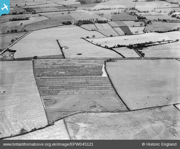
EPW045121 ENGLAND (1934). Trial plots and fields between Runcorn Road and Leigh Lane, Little Leigh, 1934
© Hawlfraint cyfranwyr OpenStreetMap a thrwyddedwyd gan yr OpenStreetMap Foundation. 2025. Trwyddedir y gartograffeg fel CC BY-SA.
Delweddau cyfagos (21)
Manylion
| Pennawd | [EPW045121] Trial plots and fields between Runcorn Road and Leigh Lane, Little Leigh, 1934 |
| Cyfeirnod | EPW045121 |
| Dyddiad | July-1934 |
| Dolen | |
| Enw lle | LITTLE LEIGH |
| Plwyf | LITTLE LEIGH |
| Ardal | |
| Gwlad | ENGLAND |
| Dwyreiniad / Gogleddiad | 361263, 376744 |
| Hydred / Lledred | -2.5811187268396, 53.285973573684 |
| Cyfeirnod Grid Cenedlaethol | SJ613767 |
Pinnau
 Bottom Yard |
Monday 3rd of December 2018 04:43:28 PM | |
 Bottom Yard |
Monday 3rd of December 2018 04:40:54 PM | |
 Bottom Yard |
Monday 3rd of December 2018 04:38:45 PM | |
 Bottom Yard |
Monday 3rd of December 2018 04:29:29 PM | |
 Bottom Yard |
Monday 3rd of December 2018 04:28:41 PM | |
 Bottom Yard |
Monday 3rd of December 2018 04:25:57 PM | |
 Bottom Yard |
Monday 3rd of December 2018 04:21:35 PM | |
 Bottom Yard |
Monday 3rd of December 2018 04:20:22 PM | |
 Bottom Yard |
Monday 3rd of December 2018 04:18:53 PM |


![[EPW045121] Trial plots and fields between Runcorn Road and Leigh Lane, Little Leigh, 1934](http://britainfromabove.org.uk/sites/all/libraries/aerofilms-images/public/100x100/EPW/045/EPW045121.jpg)
![[EPW045125] Trial plots and fields between Runcorn Road and Leigh Lane, Little Leigh, 1934](http://britainfromabove.org.uk/sites/all/libraries/aerofilms-images/public/100x100/EPW/045/EPW045125.jpg)
![[EPW032585] Trial plots and cultivated fields around the Runcorn Road, Little Leigh, from the south-west, 1930. This image has been affected by flare.](http://britainfromabove.org.uk/sites/all/libraries/aerofilms-images/public/100x100/EPW/032/EPW032585.jpg)
![[EAW030030] Fields to the south-west of Runcorn Road, Little Leigh, 1950. This image was marked by Aerofilms Ltd for photo editing.](http://britainfromabove.org.uk/sites/all/libraries/aerofilms-images/public/100x100/EAW/030/EAW030030.jpg)
![[EPW045123] Trial plots and fieldsto the south of Runcorn Road, Little Leigh, 1934](http://britainfromabove.org.uk/sites/all/libraries/aerofilms-images/public/100x100/EPW/045/EPW045123.jpg)
![[EPW032589] Trial plots and cultivated fields around the Runcorn Road, Little Leigh, from the south-west, 1930](http://britainfromabove.org.uk/sites/all/libraries/aerofilms-images/public/100x100/EPW/032/EPW032589.jpg)
![[EAW030029] Fields to the south-west of Runcorn Road, Little Leigh, 1950. This image was marked by Aerofilms Ltd for photo editing.](http://britainfromabove.org.uk/sites/all/libraries/aerofilms-images/public/100x100/EAW/030/EAW030029.jpg)
![[EPW045120] Trial plots and fields between Runcorn Road and Leigh Lane, Little Leigh, 1934](http://britainfromabove.org.uk/sites/all/libraries/aerofilms-images/public/100x100/EPW/045/EPW045120.jpg)
![[EAW030031] Fields to the south-west of Runcorn Road, Little Leigh, 1950. This image was marked by Aerofilms Ltd for photo editing.](http://britainfromabove.org.uk/sites/all/libraries/aerofilms-images/public/100x100/EAW/030/EAW030031.jpg)
![[EPW045124] Trial plots and fields between Runcorn Road and Leigh Lane, Little Leigh, 1934](http://britainfromabove.org.uk/sites/all/libraries/aerofilms-images/public/100x100/EPW/045/EPW045124.jpg)
![[EAW030019] Fields to the north and south of Runcorn Road, Little Leigh, 1950. This image was marked by Aerofilms Ltd for photo editing.](http://britainfromabove.org.uk/sites/all/libraries/aerofilms-images/public/100x100/EAW/030/EAW030019.jpg)
![[EAW030020] Fields to the north and south of Runcorn Road, Little Leigh, 1950. This image was marked by Aerofilms Ltd for photo editing.](http://britainfromabove.org.uk/sites/all/libraries/aerofilms-images/public/100x100/EAW/030/EAW030020.jpg)
![[EAW030028] Fields to the south of Ash Tree Farm, Little Leigh, 1950. This image was marked by Aerofilms Ltd for photo editing.](http://britainfromabove.org.uk/sites/all/libraries/aerofilms-images/public/100x100/EAW/030/EAW030028.jpg)
![[EAW030035] Fields to the south-west of Ash Tree Farm, Little Leigh, 1950. This image was marked by Aerofilms Ltd for photo editing.](http://britainfromabove.org.uk/sites/all/libraries/aerofilms-images/public/100x100/EAW/030/EAW030035.jpg)
![[EPW045122] Trial plots and fields between Runcorn Road and Leigh Lane, Little Leigh, 1934](http://britainfromabove.org.uk/sites/all/libraries/aerofilms-images/public/100x100/EPW/045/EPW045122.jpg)
![[EAW030033] Fields to the south of The Homestead, Little Leigh, 1950. This image was marked by Aerofilms Ltd for photo editing.](http://britainfromabove.org.uk/sites/all/libraries/aerofilms-images/public/100x100/EAW/030/EAW030033.jpg)
![[EAW030032] Fields around The Homestead, Little Leigh, 1950. This image was marked by Aerofilms Ltd for photo editing.](http://britainfromabove.org.uk/sites/all/libraries/aerofilms-images/public/100x100/EAW/030/EAW030032.jpg)
![[EAW017275] Gartons Ltd Plant Breeding Station by The Homestead, Little Leigh, 1948. This image has been produced from a print.](http://britainfromabove.org.uk/sites/all/libraries/aerofilms-images/public/100x100/EAW/017/EAW017275.jpg)
![[EAW030034] Fields around Smithy Lane, Little Leigh, 1950. This image was marked by Aerofilms Ltd for photo editing.](http://britainfromabove.org.uk/sites/all/libraries/aerofilms-images/public/100x100/EAW/030/EAW030034.jpg)
![[EAW030040] The Homestead, Little Leigh, 1950](http://britainfromabove.org.uk/sites/all/libraries/aerofilms-images/public/100x100/EAW/030/EAW030040.jpg)
![[EAW030044] The Homestead and Runcorn Road, Little Leigh, from the north-west, 1950. This image was marked by Aerofilms Ltd for photo editing.](http://britainfromabove.org.uk/sites/all/libraries/aerofilms-images/public/100x100/EAW/030/EAW030044.jpg)