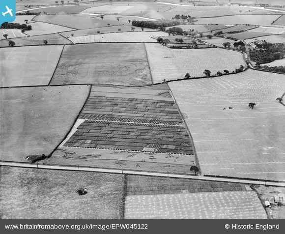
EPW045122 ENGLAND (1934). Trial plots and fields between Runcorn Road and Leigh Lane, Little Leigh, 1934
© Hawlfraint cyfranwyr OpenStreetMap a thrwyddedwyd gan yr OpenStreetMap Foundation. 2025. Trwyddedir y gartograffeg fel CC BY-SA.
Delweddau cyfagos (17)
Manylion
| Pennawd | [EPW045122] Trial plots and fields between Runcorn Road and Leigh Lane, Little Leigh, 1934 |
| Cyfeirnod | EPW045122 |
| Dyddiad | July-1934 |
| Dolen | |
| Enw lle | LITTLE LEIGH |
| Plwyf | LITTLE LEIGH |
| Ardal | |
| Gwlad | ENGLAND |
| Dwyreiniad / Gogleddiad | 361129, 376581 |
| Hydred / Lledred | -2.583108884777, 53.284498503557 |
| Cyfeirnod Grid Cenedlaethol | SJ611766 |
Pinnau
 Bottom Yard |
Wednesday 12th of December 2018 03:39:38 PM | |
 Bottom Yard |
Wednesday 12th of December 2018 03:37:39 PM | |
 Bottom Yard |
Monday 3rd of December 2018 04:54:00 PM | |
 totoro |
Wednesday 31st of July 2013 03:27:59 PM | |
 totoro |
Wednesday 31st of July 2013 03:26:42 PM | |
 totoro |
Wednesday 31st of July 2013 03:25:49 PM | |
 totoro |
Wednesday 31st of July 2013 03:25:03 PM | |
 totoro |
Wednesday 31st of July 2013 03:23:54 PM | |
 totoro |
Wednesday 31st of July 2013 03:22:53 PM | |
 totoro |
Wednesday 31st of July 2013 03:22:16 PM | |
 totoro |
Wednesday 31st of July 2013 03:10:41 PM | |
 totoro |
Wednesday 31st of July 2013 03:10:18 PM | |
 totoro |
Wednesday 31st of July 2013 03:09:22 PM |


![[EPW045122] Trial plots and fields between Runcorn Road and Leigh Lane, Little Leigh, 1934](http://britainfromabove.org.uk/sites/all/libraries/aerofilms-images/public/100x100/EPW/045/EPW045122.jpg)
![[EAW030028] Fields to the south of Ash Tree Farm, Little Leigh, 1950. This image was marked by Aerofilms Ltd for photo editing.](http://britainfromabove.org.uk/sites/all/libraries/aerofilms-images/public/100x100/EAW/030/EAW030028.jpg)
![[EAW030031] Fields to the south-west of Runcorn Road, Little Leigh, 1950. This image was marked by Aerofilms Ltd for photo editing.](http://britainfromabove.org.uk/sites/all/libraries/aerofilms-images/public/100x100/EAW/030/EAW030031.jpg)
![[EPW045124] Trial plots and fields between Runcorn Road and Leigh Lane, Little Leigh, 1934](http://britainfromabove.org.uk/sites/all/libraries/aerofilms-images/public/100x100/EPW/045/EPW045124.jpg)
![[EPW045120] Trial plots and fields between Runcorn Road and Leigh Lane, Little Leigh, 1934](http://britainfromabove.org.uk/sites/all/libraries/aerofilms-images/public/100x100/EPW/045/EPW045120.jpg)
![[EAW030029] Fields to the south-west of Runcorn Road, Little Leigh, 1950. This image was marked by Aerofilms Ltd for photo editing.](http://britainfromabove.org.uk/sites/all/libraries/aerofilms-images/public/100x100/EAW/030/EAW030029.jpg)
![[EPW045123] Trial plots and fieldsto the south of Runcorn Road, Little Leigh, 1934](http://britainfromabove.org.uk/sites/all/libraries/aerofilms-images/public/100x100/EPW/045/EPW045123.jpg)
![[EAW030020] Fields to the north and south of Runcorn Road, Little Leigh, 1950. This image was marked by Aerofilms Ltd for photo editing.](http://britainfromabove.org.uk/sites/all/libraries/aerofilms-images/public/100x100/EAW/030/EAW030020.jpg)
![[EAW030019] Fields to the north and south of Runcorn Road, Little Leigh, 1950. This image was marked by Aerofilms Ltd for photo editing.](http://britainfromabove.org.uk/sites/all/libraries/aerofilms-images/public/100x100/EAW/030/EAW030019.jpg)
![[EAW030030] Fields to the south-west of Runcorn Road, Little Leigh, 1950. This image was marked by Aerofilms Ltd for photo editing.](http://britainfromabove.org.uk/sites/all/libraries/aerofilms-images/public/100x100/EAW/030/EAW030030.jpg)
![[EPW045125] Trial plots and fields between Runcorn Road and Leigh Lane, Little Leigh, 1934](http://britainfromabove.org.uk/sites/all/libraries/aerofilms-images/public/100x100/EPW/045/EPW045125.jpg)
![[EAW030026] Fields to the east of Rosebank Cottage, Little Leigh, 1950. This image was marked by Aerofilms Ltd for photo editing.](http://britainfromabove.org.uk/sites/all/libraries/aerofilms-images/public/100x100/EAW/030/EAW030026.jpg)
![[EAW030027] Fields to the east of Rosebank Cottage, Little Leigh, 1950. This image was marked by Aerofilms Ltd for photo editing.](http://britainfromabove.org.uk/sites/all/libraries/aerofilms-images/public/100x100/EAW/030/EAW030027.jpg)
![[EPW045121] Trial plots and fields between Runcorn Road and Leigh Lane, Little Leigh, 1934](http://britainfromabove.org.uk/sites/all/libraries/aerofilms-images/public/100x100/EPW/045/EPW045121.jpg)
![[EAW030025] Fields to the north and south of Willowgreen Road, Little Leigh, 1950](http://britainfromabove.org.uk/sites/all/libraries/aerofilms-images/public/100x100/EAW/030/EAW030025.jpg)
![[EAW030024] Fields to the east of Rosebank Cottage, Little Leigh, 1950. This image was marked by Aerofilms Ltd for photo editing.](http://britainfromabove.org.uk/sites/all/libraries/aerofilms-images/public/100x100/EAW/030/EAW030024.jpg)
![[EPW032585] Trial plots and cultivated fields around the Runcorn Road, Little Leigh, from the south-west, 1930. This image has been affected by flare.](http://britainfromabove.org.uk/sites/all/libraries/aerofilms-images/public/100x100/EPW/032/EPW032585.jpg)