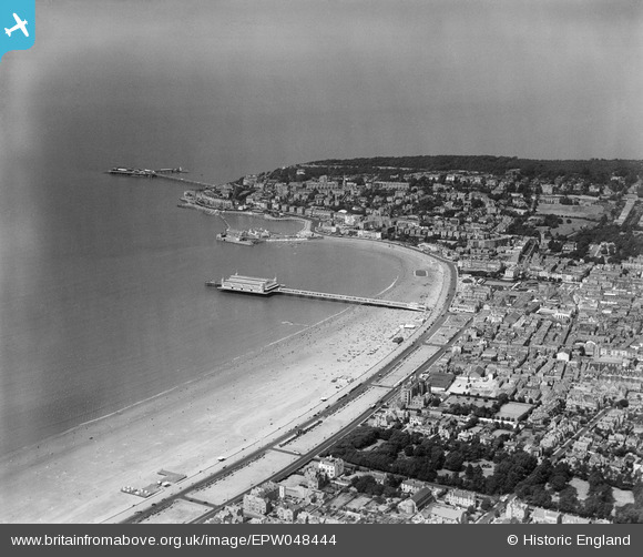
EPW048444 ENGLAND (1935). The Grand Pier, Weston Bay and the town, Weston-Super-Mare, from the south-east, 1935
© Hawlfraint cyfranwyr OpenStreetMap a thrwyddedwyd gan yr OpenStreetMap Foundation. 2025. Trwyddedir y gartograffeg fel CC BY-SA.
Delweddau cyfagos (13)
Manylion
| Pennawd | [EPW048444] The Grand Pier, Weston Bay and the town, Weston-Super-Mare, from the south-east, 1935 |
| Cyfeirnod | EPW048444 |
| Dyddiad | July-1935 |
| Dolen | |
| Enw lle | WESTON-SUPER-MARE |
| Plwyf | WESTON-SUPER-MARE |
| Ardal | |
| Gwlad | ENGLAND |
| Dwyreiniad / Gogleddiad | 331705, 160993 |
| Hydred / Lledred | -2.9806452689869, 51.343411983216 |
| Cyfeirnod Grid Cenedlaethol | ST317610 |
Pinnau
 Kentishman |
Sunday 15th of October 2023 04:20:26 PM | |
 Alan McFaden |
Saturday 19th of October 2013 03:45:33 PM | |
 Alan McFaden |
Saturday 19th of October 2013 03:44:26 PM | |
 Alan McFaden |
Saturday 19th of October 2013 03:43:24 PM | |
 Alan McFaden |
Saturday 19th of October 2013 03:41:29 PM | |
 Alan McFaden |
Saturday 19th of October 2013 03:40:38 PM |


![[EPW048444] The Grand Pier, Weston Bay and the town, Weston-Super-Mare, from the south-east, 1935](http://britainfromabove.org.uk/sites/all/libraries/aerofilms-images/public/100x100/EPW/048/EPW048444.jpg)
![[EPW048454] The Grand Pier and the town, Weston-Super-Mare, from the south, 1935](http://britainfromabove.org.uk/sites/all/libraries/aerofilms-images/public/100x100/EPW/048/EPW048454.jpg)
![[EPW051714] Beach Lawns and the town, Weston-super-Mare, from the south-west, 1936. This image has been produced from a copy-negative.](http://britainfromabove.org.uk/sites/all/libraries/aerofilms-images/public/100x100/EPW/051/EPW051714.jpg)
![[EPW001033] View over Weston-Super-Mare, Weston-Super-Mare, from the south-west, 1920](http://britainfromabove.org.uk/sites/all/libraries/aerofilms-images/public/100x100/EPW/001/EPW001033.jpg)
![[EPW023956] The Grand Atlantic Hotel, Weston-Super-Mare, 1928](http://britainfromabove.org.uk/sites/all/libraries/aerofilms-images/public/100x100/EPW/023/EPW023956.jpg)
![[EPW023961] Marine Parade, Weston-Super-Mare, from the south, 1928](http://britainfromabove.org.uk/sites/all/libraries/aerofilms-images/public/100x100/EPW/023/EPW023961.jpg)
![[EPW023957] The Grand Pier, Weston-Super-Mare, from the south, 1928](http://britainfromabove.org.uk/sites/all/libraries/aerofilms-images/public/100x100/EPW/023/EPW023957.jpg)
![[EPW048445] The Grand Pier, Weston Bay and the town, Weston-Super-Mare, from the south-east, 1935](http://britainfromabove.org.uk/sites/all/libraries/aerofilms-images/public/100x100/EPW/048/EPW048445.jpg)
![[EPW048458] The Grand Pier, Weston Bay and the town, Weston-Super-Mare, from the south-east, 1935](http://britainfromabove.org.uk/sites/all/libraries/aerofilms-images/public/100x100/EPW/048/EPW048458.jpg)
![[EPW048455] The Grand Pier and the town, Weston-Super-Mare, from the south, 1935](http://britainfromabove.org.uk/sites/all/libraries/aerofilms-images/public/100x100/EPW/048/EPW048455.jpg)
![[EAW025149] Weston Bay from the Swimming Pool (Tropicana) to Birnbeck Island, Weston-super-Mare, from the south, 1949](http://britainfromabove.org.uk/sites/all/libraries/aerofilms-images/public/100x100/EAW/025/EAW025149.jpg)
![[EAW015058] The Grand Pier and Marine Parade, Weston-super-Mare, 1948. This image has been produced from a damaged negative.](http://britainfromabove.org.uk/sites/all/libraries/aerofilms-images/public/100x100/EAW/015/EAW015058.jpg)
![[EAW056067] Worlebury Hill and the sea front, Weston-super-Mare, from the south-east, 1954](http://britainfromabove.org.uk/sites/all/libraries/aerofilms-images/public/100x100/EAW/056/EAW056067.jpg)


