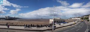
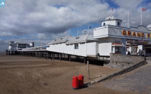
EPW048458 ENGLAND (1935). The Grand Pier, Weston Bay and the town, Weston-Super-Mare, from the south-east, 1935
© Hawlfraint cyfranwyr OpenStreetMap a thrwyddedwyd gan yr OpenStreetMap Foundation. 2025. Trwyddedir y gartograffeg fel CC BY-SA.
Delweddau cyfagos (13)
Manylion
| Pennawd | [EPW048458] The Grand Pier, Weston Bay and the town, Weston-Super-Mare, from the south-east, 1935 |
| Cyfeirnod | EPW048458 |
| Dyddiad | July-1935 |
| Dolen | |
| Enw lle | WESTON-SUPER-MARE |
| Plwyf | WESTON-SUPER-MARE |
| Ardal | |
| Gwlad | ENGLAND |
| Dwyreiniad / Gogleddiad | 331739, 160796 |
| Hydred / Lledred | -2.9801193566661, 51.341644756452 |
| Cyfeirnod Grid Cenedlaethol | ST317608 |
Pinnau
 Pete L |
Saturday 24th of January 2015 11:33:57 PM | |
This pier was taken over by the Admiralty in WW2 as an experimental station for their Department of Miscellaneous Weapon Development - see the book "Secret War 1939-45" by Gerald Pawle, published circa 1956. |
 John W |
Tuesday 10th of January 2017 09:20:24 PM |
 Alan McFaden |
Saturday 19th of October 2013 01:45:57 PM | |
 Alan McFaden |
Saturday 19th of October 2013 01:44:54 PM | |
 Alan McFaden |
Saturday 19th of October 2013 01:43:04 PM | |
 Alan McFaden |
Saturday 19th of October 2013 01:41:35 PM | |
 Alan McFaden |
Saturday 19th of October 2013 01:40:22 PM | |
 Alan McFaden |
Saturday 19th of October 2013 01:39:24 PM |


![[EPW048458] The Grand Pier, Weston Bay and the town, Weston-Super-Mare, from the south-east, 1935](http://britainfromabove.org.uk/sites/all/libraries/aerofilms-images/public/100x100/EPW/048/EPW048458.jpg)
![[EPW023961] Marine Parade, Weston-Super-Mare, from the south, 1928](http://britainfromabove.org.uk/sites/all/libraries/aerofilms-images/public/100x100/EPW/023/EPW023961.jpg)
![[EPW048455] The Grand Pier and the town, Weston-Super-Mare, from the south, 1935](http://britainfromabove.org.uk/sites/all/libraries/aerofilms-images/public/100x100/EPW/048/EPW048455.jpg)
![[EPW001033] View over Weston-Super-Mare, Weston-Super-Mare, from the south-west, 1920](http://britainfromabove.org.uk/sites/all/libraries/aerofilms-images/public/100x100/EPW/001/EPW001033.jpg)
![[EPW033281] Ellenborough Park and environs, Weston-Super-Mare, 1930](http://britainfromabove.org.uk/sites/all/libraries/aerofilms-images/public/100x100/EPW/033/EPW033281.jpg)
![[EAW025156] The Swimming Pool (Tropicana), Weston-super-Mare, 1949](http://britainfromabove.org.uk/sites/all/libraries/aerofilms-images/public/100x100/EAW/025/EAW025156.jpg)
![[EPW051725] The Swimming Pool (Tropicana) under construction, Beach Lawns and the town, Weston-super-Mare, from the south-west, 1936. This image has been produced from a copy-negative marked by Aerofilms Ltd for photo editing.](http://britainfromabove.org.uk/sites/all/libraries/aerofilms-images/public/100x100/EPW/051/EPW051725.jpg)
![[EPW048444] The Grand Pier, Weston Bay and the town, Weston-Super-Mare, from the south-east, 1935](http://britainfromabove.org.uk/sites/all/libraries/aerofilms-images/public/100x100/EPW/048/EPW048444.jpg)
![[EPW048454] The Grand Pier and the town, Weston-Super-Mare, from the south, 1935](http://britainfromabove.org.uk/sites/all/libraries/aerofilms-images/public/100x100/EPW/048/EPW048454.jpg)
![[EPW023956] The Grand Atlantic Hotel, Weston-Super-Mare, 1928](http://britainfromabove.org.uk/sites/all/libraries/aerofilms-images/public/100x100/EPW/023/EPW023956.jpg)
![[EAW025157] The Swimming Pool (Tropicana), Weston-super-Mare, 1949](http://britainfromabove.org.uk/sites/all/libraries/aerofilms-images/public/100x100/EAW/025/EAW025157.jpg)
![[EAW025149] Weston Bay from the Swimming Pool (Tropicana) to Birnbeck Island, Weston-super-Mare, from the south, 1949](http://britainfromabove.org.uk/sites/all/libraries/aerofilms-images/public/100x100/EAW/025/EAW025149.jpg)
![[EPW051714] Beach Lawns and the town, Weston-super-Mare, from the south-west, 1936. This image has been produced from a copy-negative.](http://britainfromabove.org.uk/sites/all/libraries/aerofilms-images/public/100x100/EPW/051/EPW051714.jpg)
