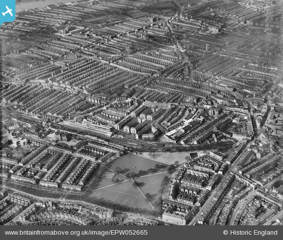
EPW052665 ENGLAND (1937). Eel Brook Common and surrounding residential area, Parsons Green, from the south-east, 1937
© Hawlfraint cyfranwyr OpenStreetMap a thrwyddedwyd gan yr OpenStreetMap Foundation. 2025. Trwyddedir y gartograffeg fel CC BY-SA.
Manylion
| Pennawd | [EPW052665] Eel Brook Common and surrounding residential area, Parsons Green, from the south-east, 1937 |
| Cyfeirnod | EPW052665 |
| Dyddiad | 12-March-1937 |
| Dolen | |
| Enw lle | PARSONS GREEN |
| Plwyf | |
| Ardal | |
| Gwlad | ENGLAND |
| Dwyreiniad / Gogleddiad | 525427, 176854 |
| Hydred / Lledred | -0.19372512323698, 51.476237230427 |
| Cyfeirnod Grid Cenedlaethol | TQ254769 |
Pinnau
 Keith Cheriton |
Tuesday 14th of November 2017 03:34:12 PM | |
 Keith Cheriton |
Tuesday 14th of November 2017 03:32:22 PM | |
 Keith Cheriton |
Thursday 6th of February 2014 03:47:51 PM | |
 Keith Cheriton |
Thursday 6th of February 2014 03:45:26 PM | |
 Keith Cheriton |
Thursday 6th of February 2014 03:43:43 PM | |
 Keith Cheriton |
Thursday 6th of February 2014 03:42:53 PM | |
 Keith Cheriton |
Thursday 6th of February 2014 03:41:35 PM | |
 Keith Cheriton |
Thursday 6th of February 2014 03:40:33 PM |


![[EPW052665] Eel Brook Common and surrounding residential area, Parsons Green, from the south-east, 1937](http://britainfromabove.org.uk/sites/all/libraries/aerofilms-images/public/100x100/EPW/052/EPW052665.jpg)
![[EPW052677] Eel Brook Common, Sands End and environs, Parsons Green, 1937](http://britainfromabove.org.uk/sites/all/libraries/aerofilms-images/public/100x100/EPW/052/EPW052677.jpg)
![[EPW052674] Fulham Court and surrounding residential area, Fulham, from the south-east, 1937](http://britainfromabove.org.uk/sites/all/libraries/aerofilms-images/public/100x100/EPW/052/EPW052674.jpg)