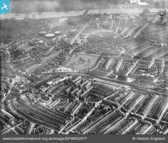
EPW052677 ENGLAND (1937). Eel Brook Common, Sands End and environs, Parsons Green, 1937
© Hawlfraint cyfranwyr OpenStreetMap a thrwyddedwyd gan yr OpenStreetMap Foundation. 2025. Trwyddedir y gartograffeg fel CC BY-SA.
Delweddau cyfagos (11)
Manylion
| Pennawd | [EPW052677] Eel Brook Common, Sands End and environs, Parsons Green, 1937 |
| Cyfeirnod | EPW052677 |
| Dyddiad | 12-March-1937 |
| Dolen | |
| Enw lle | PARSONS GREEN |
| Plwyf | |
| Ardal | |
| Gwlad | ENGLAND |
| Dwyreiniad / Gogleddiad | 525359, 176863 |
| Hydred / Lledred | -0.1947006744367, 51.476333198353 |
| Cyfeirnod Grid Cenedlaethol | TQ254769 |
Pinnau
 ap493 |
Tuesday 14th of November 2023 11:22:15 PM | |
 Keith Cheriton |
Tuesday 14th of November 2017 03:36:58 PM | |
 Keith Cheriton |
Tuesday 14th of November 2017 03:36:05 PM |


![[EPW052677] Eel Brook Common, Sands End and environs, Parsons Green, 1937](http://britainfromabove.org.uk/sites/all/libraries/aerofilms-images/public/100x100/EPW/052/EPW052677.jpg)
![[EPW052665] Eel Brook Common and surrounding residential area, Parsons Green, from the south-east, 1937](http://britainfromabove.org.uk/sites/all/libraries/aerofilms-images/public/100x100/EPW/052/EPW052665.jpg)
![[EPW052674] Fulham Court and surrounding residential area, Fulham, from the south-east, 1937](http://britainfromabove.org.uk/sites/all/libraries/aerofilms-images/public/100x100/EPW/052/EPW052674.jpg)
![[EPW052669] Fulham Court and environs, Fulham, 1937](http://britainfromabove.org.uk/sites/all/libraries/aerofilms-images/public/100x100/EPW/052/EPW052669.jpg)
![[EPW052671] Fulham Court, Fulham, 1937](http://britainfromabove.org.uk/sites/all/libraries/aerofilms-images/public/100x100/EPW/052/EPW052671.jpg)
![[EPW052672] Fulham Court and environs, Fulham, 1937](http://britainfromabove.org.uk/sites/all/libraries/aerofilms-images/public/100x100/EPW/052/EPW052672.jpg)
![[EPW052673] Fulham Court and environs, Fulham, 1937](http://britainfromabove.org.uk/sites/all/libraries/aerofilms-images/public/100x100/EPW/052/EPW052673.jpg)
![[EPW052666] Fulham Court and environs, Fulham, 1937](http://britainfromabove.org.uk/sites/all/libraries/aerofilms-images/public/100x100/EPW/052/EPW052666.jpg)
![[EPW052668] Fulham Court and environs, Fulham, 1937](http://britainfromabove.org.uk/sites/all/libraries/aerofilms-images/public/100x100/EPW/052/EPW052668.jpg)
![[EPW052678] Fulham Court and surrounding residential area, Fulham, 1937](http://britainfromabove.org.uk/sites/all/libraries/aerofilms-images/public/100x100/EPW/052/EPW052678.jpg)
![[EPW052670] Fulham Court, Fulham, 1937](http://britainfromabove.org.uk/sites/all/libraries/aerofilms-images/public/100x100/EPW/052/EPW052670.jpg)