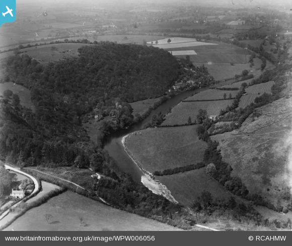
WPW006056 WALES (1921). View of landscape near Monmouth, oblique aerial view. 5"x4" black and white glass plate negative.
© Hawlfraint cyfranwyr OpenStreetMap a thrwyddedwyd gan yr OpenStreetMap Foundation. 2025. Trwyddedir y gartograffeg fel CC BY-SA.
Delweddau cyfagos (48)
Manylion
| Pennawd | [WPW006056] View of landscape near Monmouth, oblique aerial view. 5"x4" black and white glass plate negative. |
| Cyfeirnod | WPW006056 |
| Dyddiad | 1921 |
| Dolen | Coflein Archive Item 6370301 |
| Enw lle | |
| Plwyf | |
| Ardal | |
| Gwlad | WALES |
| Dwyreiniad / Gogleddiad | 350740, 212819 |
| Hydred / Lledred | -2.7146209238032, 51.811384535538 |
| Cyfeirnod Grid Cenedlaethol | SO507128 |
Pinnau
Cyfraniadau Grŵp
This is Symonds Yat again? The road bottom left is from from Christchurch down to Yat Rock. The loop of the Wye goes out into the distance to Goodrich before return to Symonds Yat. The tracks at the bottom of the photo are Coldwell Walks which were a well used by tourists. Coppit Hill on the left is now covered in Woodland, and the buildings on the edge of the fields are still there, the old farmhouse is derelict. |
 fredb |
Thursday 8th of May 2014 03:24:29 PM |


![[WAW007084] View west of Monmouth looking North West from Llangynidr to Brecon on River Usk](http://britainfromabove.org.uk/sites/all/libraries/aerofilms-images/public/100x100/WAW/007/WAW007084.jpg)
![[WAW007085] View west of Monmouth looking North West from Llangynidr to Brecon on River Usk](http://britainfromabove.org.uk/sites/all/libraries/aerofilms-images/public/100x100/WAW/007/WAW007085.jpg)
![[WAW007086] View west of Monmouth looking North West from Llangynidr to Brecon on River Usk](http://britainfromabove.org.uk/sites/all/libraries/aerofilms-images/public/100x100/WAW/007/WAW007086.jpg)
![[WAW007087] View west of Monmouth looking North West from Llangynidr to Brecon on River Usk](http://britainfromabove.org.uk/sites/all/libraries/aerofilms-images/public/100x100/WAW/007/WAW007087.jpg)
![[WAW007088] Distant view of Monmouth](http://britainfromabove.org.uk/sites/all/libraries/aerofilms-images/public/100x100/WAW/007/WAW007088.jpg)
![[WAW007089] Distant view of Monmouth](http://britainfromabove.org.uk/sites/all/libraries/aerofilms-images/public/100x100/WAW/007/WAW007089.jpg)
![[WAW016142] General view of Monmouth](http://britainfromabove.org.uk/sites/all/libraries/aerofilms-images/public/100x100/WAW/016/WAW016142.jpg)
![[WAW016143] General view of Monmouth](http://britainfromabove.org.uk/sites/all/libraries/aerofilms-images/public/100x100/WAW/016/WAW016143.jpg)
![[WPW006051] General view of Monmouth, oblique aerial view. 5"x4" black and white glass plate negative.](http://britainfromabove.org.uk/sites/all/libraries/aerofilms-images/public/100x100/WPW/006/WPW006051.jpg)
![[WPW006052] View of Monmouth showing cattle market and fairground with fair in progress, oblique aerial view. 5"x4" black and white glass plate negative.](http://britainfromabove.org.uk/sites/all/libraries/aerofilms-images/public/100x100/WPW/006/WPW006052.jpg)
![[WPW006053] General view of Monmouth, oblique aerial view. 5"x4" black and white glass plate negative.](http://britainfromabove.org.uk/sites/all/libraries/aerofilms-images/public/100x100/WPW/006/WPW006053.jpg)
![[WPW006054] General view of Monmouth, oblique aerial view. 5"x4" black and white glass plate negative.](http://britainfromabove.org.uk/sites/all/libraries/aerofilms-images/public/100x100/WPW/006/WPW006054.jpg)
![[WPW006055] View of landscape near Monmouth, oblique aerial view. 5"x4" black and white glass plate negative.](http://britainfromabove.org.uk/sites/all/libraries/aerofilms-images/public/100x100/WPW/006/WPW006055.jpg)
![[WPW006056] View of landscape near Monmouth, oblique aerial view. 5"x4" black and white glass plate negative.](http://britainfromabove.org.uk/sites/all/libraries/aerofilms-images/public/100x100/WPW/006/WPW006056.jpg)
![[WPW006057] View of landscape near Monmouth, oblique aerial view. 5"x4" black and white glass plate negative.](http://britainfromabove.org.uk/sites/all/libraries/aerofilms-images/public/100x100/WPW/006/WPW006057.jpg)
![[WPW006058] View of landscape near Monmouth, oblique aerial view. 5"x4" black and white glass plate negative.](http://britainfromabove.org.uk/sites/all/libraries/aerofilms-images/public/100x100/WPW/006/WPW006058.jpg)
![[WPW006059] View of landscape near Monmouth, oblique aerial view. 5"x4" black and white glass plate negative.](http://britainfromabove.org.uk/sites/all/libraries/aerofilms-images/public/100x100/WPW/006/WPW006059.jpg)
![[WPW029894] General view of Monmouth, oblique aerial view. 5"x4" black and white glass plate negative.](http://britainfromabove.org.uk/sites/all/libraries/aerofilms-images/public/100x100/WPW/029/WPW029894.jpg)
![[WPW029895] General view of Monmouth, oblique aerial view. 5"x4" black and white glass plate negative.](http://britainfromabove.org.uk/sites/all/libraries/aerofilms-images/public/100x100/WPW/029/WPW029895.jpg)
![[WPW029896] General view of Monmouth, oblique aerial view. 5"x4" black and white glass plate negative.](http://britainfromabove.org.uk/sites/all/libraries/aerofilms-images/public/100x100/WPW/029/WPW029896.jpg)
![[WPW029902] General view of Monmouth, oblique aerial view. 5"x4" black and white glass plate negative.](http://britainfromabove.org.uk/sites/all/libraries/aerofilms-images/public/100x100/WPW/029/WPW029902.jpg)
![[WPW029903] General view of Monmouth, oblique aerial view. 5"x4" black and white glass plate negative.](http://britainfromabove.org.uk/sites/all/libraries/aerofilms-images/public/100x100/WPW/029/WPW029903.jpg)
![[WPW029904] General view of Monmouth, oblique aerial view. 5"x4" black and white glass plate negative.](http://britainfromabove.org.uk/sites/all/libraries/aerofilms-images/public/100x100/WPW/029/WPW029904.jpg)
![[WPW029908] View of Wye Bridge, Monmouth, oblique aerial view. 5"x4" black and white glass plate negative.](http://britainfromabove.org.uk/sites/all/libraries/aerofilms-images/public/100x100/WPW/029/WPW029908.jpg)
![[WPW039974] General view of Monmouth, oblique aerial view. 5"x4" black and white glass plate negative.](http://britainfromabove.org.uk/sites/all/libraries/aerofilms-images/public/100x100/WPW/039/WPW039974.jpg)
![[WPW039975] General view of Monmouth, oblique aerial view. 5"x4" black and white glass plate negative.](http://britainfromabove.org.uk/sites/all/libraries/aerofilms-images/public/100x100/WPW/039/WPW039975.jpg)
![[WPW039976] General view of Monmouth, oblique aerial view. 5"x4" black and white glass plate negative.](http://britainfromabove.org.uk/sites/all/libraries/aerofilms-images/public/100x100/WPW/039/WPW039976.jpg)
![[WPW039977] General view of Monmouth, oblique aerial view. 5"x4" black and white glass plate negative.](http://britainfromabove.org.uk/sites/all/libraries/aerofilms-images/public/100x100/WPW/039/WPW039977.jpg)
![[WPW048170] View of Monmouth, oblique aerial view. 5"x4" black and white glass plate negative.](http://britainfromabove.org.uk/sites/all/libraries/aerofilms-images/public/100x100/WPW/048/WPW048170.jpg)
![[WPW048171] View of Monmouth, oblique aerial view. 5"x4" black and white glass plate negative.](http://britainfromabove.org.uk/sites/all/libraries/aerofilms-images/public/100x100/WPW/048/WPW048171.jpg)
![[WPW048172] View of Monmouth showing school, oblique aerial view. 5"x4" black and white glass plate negative.](http://britainfromabove.org.uk/sites/all/libraries/aerofilms-images/public/100x100/WPW/048/WPW048172.jpg)
![[WPW048173] View of Monmouth showing school, oblique aerial view. 5"x4" black and white glass plate negative.](http://britainfromabove.org.uk/sites/all/libraries/aerofilms-images/public/100x100/WPW/048/WPW048173.jpg)
![[WPW048174] View of Monmouth showing school, oblique aerial view. 5"x4" black and white glass plate negative.](http://britainfromabove.org.uk/sites/all/libraries/aerofilms-images/public/100x100/WPW/048/WPW048174.jpg)
![[WPW048175] View of Monmouth showing school, oblique aerial view. 5"x4" black and white glass plate negative.](http://britainfromabove.org.uk/sites/all/libraries/aerofilms-images/public/100x100/WPW/048/WPW048175.jpg)
![[WPW048176] View of Monmouth showing school, oblique aerial view. 5"x4" black and white glass plate negative.](http://britainfromabove.org.uk/sites/all/libraries/aerofilms-images/public/100x100/WPW/048/WPW048176.jpg)
![[WPW048177] View of Monmouth showing school, oblique aerial view. 5"x4" black and white glass plate negative.](http://britainfromabove.org.uk/sites/all/libraries/aerofilms-images/public/100x100/WPW/048/WPW048177.jpg)
![[WPW048178] View of Monmouth showing school, oblique aerial view. 5"x4" black and white glass plate negative.](http://britainfromabove.org.uk/sites/all/libraries/aerofilms-images/public/100x100/WPW/048/WPW048178.jpg)
![[WPW048179] View of Monmouth showing school and viaduct, oblique aerial view. 5"x4" black and white glass plate negative.](http://britainfromabove.org.uk/sites/all/libraries/aerofilms-images/public/100x100/WPW/048/WPW048179.jpg)
![[WPW048180] View of Monmouth showing school and viaduct, oblique aerial view. 5"x4" black and white glass plate negative.](http://britainfromabove.org.uk/sites/all/libraries/aerofilms-images/public/100x100/WPW/048/WPW048180.jpg)
![[WPW048181] View of Monmouth showing school and viaduct, oblique aerial view. 5"x4" black and white glass plate negative.](http://britainfromabove.org.uk/sites/all/libraries/aerofilms-images/public/100x100/WPW/048/WPW048181.jpg)
![[WPW058582] General view of Monmouth, oblique aerial view. 5"x4" black and white glass plate negative.](http://britainfromabove.org.uk/sites/all/libraries/aerofilms-images/public/100x100/WPW/058/WPW058582.jpg)
![[WPW058583] General view of Monmouth, oblique aerial view. 5"x4" black and white glass plate negative.](http://britainfromabove.org.uk/sites/all/libraries/aerofilms-images/public/100x100/WPW/058/WPW058583.jpg)
![[WPW058584] General view of Monmouth, oblique aerial view. 5"x4" black and white glass plate negative.](http://britainfromabove.org.uk/sites/all/libraries/aerofilms-images/public/100x100/WPW/058/WPW058584.jpg)
![[WPW058585] General view of Monmouth, oblique aerial view. 5"x4" black and white glass plate negative.](http://britainfromabove.org.uk/sites/all/libraries/aerofilms-images/public/100x100/WPW/058/WPW058585.jpg)
![[WPW058586] General view of Monmouth, oblique aerial view. 5"x4" black and white glass plate negative.](http://britainfromabove.org.uk/sites/all/libraries/aerofilms-images/public/100x100/WPW/058/WPW058586.jpg)
![[WPW058587] View of Monmouth showing Monnow Bridge, Monnow Street and Cattle Market, oblique aerial view. 5"x4" black and white glass plate negative.](http://britainfromabove.org.uk/sites/all/libraries/aerofilms-images/public/100x100/WPW/058/WPW058587.jpg)
![[WPW058588] View of Monmouth showing Monnow bridge and cattle market. Oblique aerial photograph, 5"x4" BW glass plate.](http://britainfromabove.org.uk/sites/all/libraries/aerofilms-images/public/100x100/WPW/058/WPW058588.jpg)
![[WPW029905] View of Monmouth showing school, oblique aerial view. 5"x4" black and white glass plate negative.](http://britainfromabove.org.uk/sites/all/libraries/aerofilms-images/public/100x100/WPW/029/WPW029905.jpg)