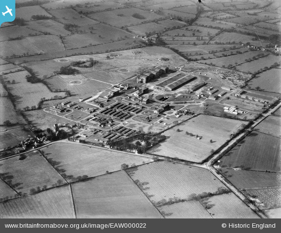
EAW000022 ENGLAND (1946). RAF Wythall (Barrage Balloon Station) and surrounding countryside, Wythall, 1946
© Copyright OpenStreetMap contributors and licensed by the OpenStreetMap Foundation. 2024. Cartography is licensed as CC BY-SA.
Nearby Images (6)
Details
| Title | [EAW000022] RAF Wythall (Barrage Balloon Station) and surrounding countryside, Wythall, 1946 |
| Reference | EAW000022 |
| Date | 24-January-1946 |
| Link | |
| Place name | WYTHALL |
| Parish | WYTHALL |
| District | |
| Country | ENGLAND |
| Easting / Northing | 407217, 275079 |
| Longitude / Latitude | -1.8939790448186, 52.373325041393 |
| National Grid Reference | SP072751 |
Pins
 Terry |
Friday 23rd of December 2016 09:35:14 AM | |
 Terry |
Friday 23rd of December 2016 09:34:10 AM | |
 Hargow |
Saturday 21st of February 2015 08:49:37 PM | |
 Hargow |
Saturday 21st of February 2015 08:49:06 PM | |
 Hargow |
Saturday 21st of February 2015 08:47:57 PM |


![[EAW000022] RAF Wythall (Barrage Balloon Station) and surrounding countryside, Wythall, 1946](http://britainfromabove.org.uk/sites/all/libraries/aerofilms-images/public/100x100/EAW/000/EAW000022.jpg)
![[EAW000021] RAF Wythall (Barrage Balloon Station), Wythall, 1946](http://britainfromabove.org.uk/sites/all/libraries/aerofilms-images/public/100x100/EAW/000/EAW000021.jpg)
![[EAW000018] RAF Wythall (Barrage Balloon Station), Wythall, 1946](http://britainfromabove.org.uk/sites/all/libraries/aerofilms-images/public/100x100/EAW/000/EAW000018.jpg)
![[EAW000020] RAF Wythall (Barrage Balloon Station), Wythall, 1946](http://britainfromabove.org.uk/sites/all/libraries/aerofilms-images/public/100x100/EAW/000/EAW000020.jpg)
![[EAW000019] RAF Wythall (Barrage Balloon Station), Wythall, 1946](http://britainfromabove.org.uk/sites/all/libraries/aerofilms-images/public/100x100/EAW/000/EAW000019.jpg)
![[EAW000016] RAF Wythall (Barrage Balloon Station), Wythall, 1946](http://britainfromabove.org.uk/sites/all/libraries/aerofilms-images/public/100x100/EAW/000/EAW000016.jpg)