
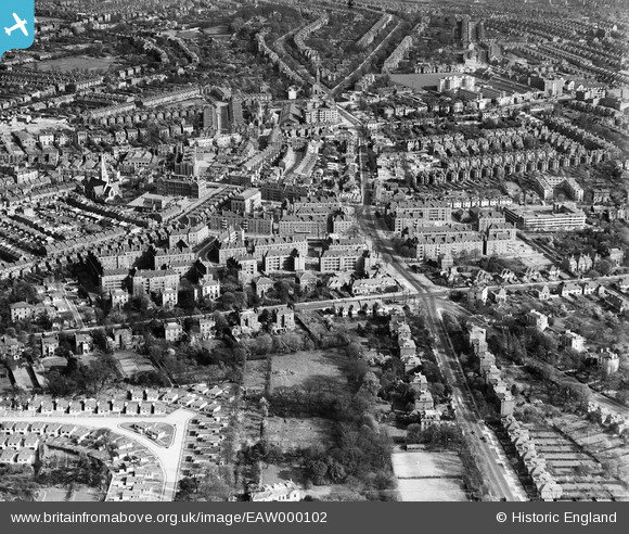
EAW000102 ENGLAND (1946). Blocks of flats off Atkins Road and environs, Clapham Park, 1946
© Copyright OpenStreetMap contributors and licensed by the OpenStreetMap Foundation. 2025. Cartography is licensed as CC BY-SA.
Nearby Images (8)
EAW000102

EAW000103

EAW030128

EAW000101

EAW000100

EAW000099

EAW000104

EAW000105

Details
| Title | [EAW000102] Blocks of flats off Atkins Road and environs, Clapham Park, 1946 |
| Reference | EAW000102 |
| Date | 4-April-1946 |
| Link | |
| Place name | CLAPHAM PARK |
| Parish | |
| District | |
| Country | ENGLAND |
| Easting / Northing | 529991, 173802 |
| Longitude / Latitude | -0.12915827498332, 51.44777609229 |
| National Grid Reference | TQ300738 |
Pins
 brianbeckett |
Thursday 18th of September 2014 11:26:03 AM | |
The pin is displayed in Atkins Road. Kings Avenue runs below, left to right in this image. |
robguy |
Monday 13th of October 2014 10:01:41 PM |
User Comment Contributions
Agree With Robguy Pin wrongly located |
taxiphil |
Thursday 26th of May 2016 07:11:08 PM |