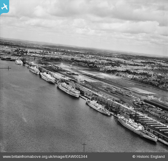
EAW001344 ENGLAND (1946). The New Docks (Western Docks), Southampton, from the south, 1946
© Copyright OpenStreetMap contributors and licensed by the OpenStreetMap Foundation. 2025. Cartography is licensed as CC BY-SA.
Nearby Images (39)
Details
| Title | [EAW001344] The New Docks (Western Docks), Southampton, from the south, 1946 |
| Reference | EAW001344 |
| Date | 28-June-1946 |
| Link | |
| Place name | SOUTHAMPTON |
| Parish | |
| District | |
| Country | ENGLAND |
| Easting / Northing | 440890, 111533 |
| Longitude / Latitude | -1.4184444393521, 50.901270136015 |
| National Grid Reference | SU409115 |
Pins
 redmist |
Wednesday 21st of December 2022 01:22:19 PM | |
 redmist |
Wednesday 21st of December 2022 01:21:27 PM | |
 redmist |
Wednesday 21st of December 2022 01:20:44 PM | |
 redmist |
Wednesday 21st of December 2022 01:19:06 PM | |
 redmist |
Monday 5th of December 2022 09:50:58 PM | |
 MB |
Monday 16th of September 2013 11:32:45 PM | |
 MB |
Monday 16th of September 2013 11:31:23 PM |


![[EAW001344] The New Docks (Western Docks), Southampton, from the south, 1946](http://britainfromabove.org.uk/sites/all/libraries/aerofilms-images/public/100x100/EAW/001/EAW001344.jpg)
![[EAW001338] The New Docks (Western Docks), Southampton, 1946](http://britainfromabove.org.uk/sites/all/libraries/aerofilms-images/public/100x100/EAW/001/EAW001338.jpg)
![[EAW020013] Construction work at J. Rank Ltd Solent Flour Mills, Southampton, 1948. This image was marked by Aerofilms Ltd for photo editing.](http://britainfromabove.org.uk/sites/all/libraries/aerofilms-images/public/100x100/EAW/020/EAW020013.jpg)
![[EAW035617] Joseph Rank Ltd Solent Flour Mills, Southampton, 1951](http://britainfromabove.org.uk/sites/all/libraries/aerofilms-images/public/100x100/EAW/035/EAW035617.jpg)
![[EAW035618] Joseph Rank Ltd Solent Flour Mills, Southampton, 1951. This image was marked by Aerofilms Ltd for photo editing.](http://britainfromabove.org.uk/sites/all/libraries/aerofilms-images/public/100x100/EAW/035/EAW035618.jpg)
![[EAW035621] Joseph Rank Ltd Solent Flour Mills, Southampton, 1951. This image has been produced from a print marked by Aerofilms Ltd for photo editing.](http://britainfromabove.org.uk/sites/all/libraries/aerofilms-images/public/100x100/EAW/035/EAW035621.jpg)
![[EAW035615] Joseph Rank Ltd Solent Flour Mills, Southampton, 1951](http://britainfromabove.org.uk/sites/all/libraries/aerofilms-images/public/100x100/EAW/035/EAW035615.jpg)
![[EAW020015] Construction work at J. Rank Ltd Solent Flour Mills, Southampton, 1948. This image was marked by Aerofilms Ltd for photo editing.](http://britainfromabove.org.uk/sites/all/libraries/aerofilms-images/public/100x100/EAW/020/EAW020015.jpg)
![[EAW035623] Joseph Rank Ltd Solent Flour Mills, Southampton, 1951. This image has been produced from a print marked by Aerofilms Ltd for photo editing.](http://britainfromabove.org.uk/sites/all/libraries/aerofilms-images/public/100x100/EAW/035/EAW035623.jpg)
![[EAW020019] Construction work at J. Rank Ltd Solent Flour Mills, Southampton, 1948](http://britainfromabove.org.uk/sites/all/libraries/aerofilms-images/public/100x100/EAW/020/EAW020019.jpg)
![[EAW035619] Joseph Rank Ltd Solent Flour Mills, Southampton, 1951. This image was marked by Aerofilms Ltd for photo editing.](http://britainfromabove.org.uk/sites/all/libraries/aerofilms-images/public/100x100/EAW/035/EAW035619.jpg)
![[EAW004217] J. Rank Ltd Solent Flour Mills, Southampton, 1947](http://britainfromabove.org.uk/sites/all/libraries/aerofilms-images/public/100x100/EAW/004/EAW004217.jpg)
![[EAW035620] Joseph Rank Ltd Solent Flour Mills, Southampton, 1951. This image has been produced from a print marked by Aerofilms Ltd for photo editing.](http://britainfromabove.org.uk/sites/all/libraries/aerofilms-images/public/100x100/EAW/035/EAW035620.jpg)
![[EAW001337] The New Docks (Western Docks), Southampton, from the south-east, 1946](http://britainfromabove.org.uk/sites/all/libraries/aerofilms-images/public/100x100/EAW/001/EAW001337.jpg)
![[EAW035622] Joseph Rank Ltd Solent Flour Mills, Southampton, 1951. This image has been produced from a print marked by Aerofilms Ltd for photo editing.](http://britainfromabove.org.uk/sites/all/libraries/aerofilms-images/public/100x100/EAW/035/EAW035622.jpg)
![[EAW035625] Joseph Rank Ltd Solent Flour Mills, Southampton, 1951. This image has been produced from a print marked by Aerofilms Ltd for photo editing.](http://britainfromabove.org.uk/sites/all/libraries/aerofilms-images/public/100x100/EAW/035/EAW035625.jpg)
![[EAW020012] Construction work at J. Rank Ltd Solent Flour Mills, Southampton, 1948](http://britainfromabove.org.uk/sites/all/libraries/aerofilms-images/public/100x100/EAW/020/EAW020012.jpg)
![[EAW004215] J. Rank Ltd Solent Flour Mills, Southampton, 1947](http://britainfromabove.org.uk/sites/all/libraries/aerofilms-images/public/100x100/EAW/004/EAW004215.jpg)
![[EAW002825] The Grey Ghost (RMS Queen Mary) and RMS Queen Elizabeth at the New Docks (Western Docks), Southampton, from the south, 1946](http://britainfromabove.org.uk/sites/all/libraries/aerofilms-images/public/100x100/EAW/002/EAW002825.jpg)
![[EAW020018] Construction work at J. Rank Ltd Solent Flour Mills and environs, Southampton, 1948. This image was marked by Aerofilms Ltd for photo editing.](http://britainfromabove.org.uk/sites/all/libraries/aerofilms-images/public/100x100/EAW/020/EAW020018.jpg)
![[EAW020021] Construction work at J. Rank Ltd Solent Flour Mills, Southampton, 1948. This image has been produced from a print marked by Aerofilms Ltd for photo editing.](http://britainfromabove.org.uk/sites/all/libraries/aerofilms-images/public/100x100/EAW/020/EAW020021.jpg)
![[EAW004220] J. Rank Ltd Solent Flour Mills, Southampton, 1947](http://britainfromabove.org.uk/sites/all/libraries/aerofilms-images/public/100x100/EAW/004/EAW004220.jpg)
![[EPW032349] New docks (Western Docks) under construction, Southampton, from the west, 1930. This image has been produced from a copy-negative.](http://britainfromabove.org.uk/sites/all/libraries/aerofilms-images/public/100x100/EPW/032/EPW032349.jpg)
![[EAW004218] J. Rank Ltd Solent Flour Mills, Southampton, 1947](http://britainfromabove.org.uk/sites/all/libraries/aerofilms-images/public/100x100/EAW/004/EAW004218.jpg)
![[EAW004214] J. Rank Ltd Solent Flour Mills, Southampton, 1947](http://britainfromabove.org.uk/sites/all/libraries/aerofilms-images/public/100x100/EAW/004/EAW004214.jpg)
![[EAW004221] J. Rank Ltd Solent Flour Mills, Southampton, 1947](http://britainfromabove.org.uk/sites/all/libraries/aerofilms-images/public/100x100/EAW/004/EAW004221.jpg)
![[EAW022292] A Union-Castle Line ship at the New Docks (Western Docks), Southampton, 1949](http://britainfromabove.org.uk/sites/all/libraries/aerofilms-images/public/100x100/EAW/022/EAW022292.jpg)
![[EAW004216] J. Rank Ltd Solent Flour Mills, Southampton, 1947](http://britainfromabove.org.uk/sites/all/libraries/aerofilms-images/public/100x100/EAW/004/EAW004216.jpg)
![[EAW035616] Joseph Rank Ltd Solent Flour Mills, Southampton, 1951. This image has been produced from a print marked by Aerofilms Ltd for photo editing.](http://britainfromabove.org.uk/sites/all/libraries/aerofilms-images/public/100x100/EAW/035/EAW035616.jpg)
![[EAW035624] Joseph Rank Ltd Solent Flour Mills, Southampton, 1951. This image has been produced from a print marked by Aerofilms Ltd for photo editing.](http://britainfromabove.org.uk/sites/all/libraries/aerofilms-images/public/100x100/EAW/035/EAW035624.jpg)
![[EAW001363] RMS Queen Elizabeth at the New Docks (Western Docks), Southampton, from the south-west, 1946](http://britainfromabove.org.uk/sites/all/libraries/aerofilms-images/public/100x100/EAW/001/EAW001363.jpg)
![[EAW004213] J. Rank Ltd Solent Flour Mills, Southampton, 1947](http://britainfromabove.org.uk/sites/all/libraries/aerofilms-images/public/100x100/EAW/004/EAW004213.jpg)
![[EAW004219] J. Rank Ltd Solent Flour Mills, Southampton, 1947](http://britainfromabove.org.uk/sites/all/libraries/aerofilms-images/public/100x100/EAW/004/EAW004219.jpg)
![[EAW001339] RMS Queen Elizabeth at the New Docks (Western Docks), Southampton, from the south-east, 1946](http://britainfromabove.org.uk/sites/all/libraries/aerofilms-images/public/100x100/EAW/001/EAW001339.jpg)
![[EAW001362] RMS Queen Elizabeth at the New Docks (Western Docks), Southampton, 1946](http://britainfromabove.org.uk/sites/all/libraries/aerofilms-images/public/100x100/EAW/001/EAW001362.jpg)
![[EAW020020] Construction work at J. Rank Ltd Solent Flour Mills, Southampton, 1948. This image has been produced from a print marked by Aerofilms Ltd for photo editing.](http://britainfromabove.org.uk/sites/all/libraries/aerofilms-images/public/100x100/EAW/020/EAW020020.jpg)
![[EAW020016] Construction work at J. Rank Ltd Solent Flour Mills, Southampton, 1948. This image was marked by Aerofilms Ltd for photo editing.](http://britainfromabove.org.uk/sites/all/libraries/aerofilms-images/public/100x100/EAW/020/EAW020016.jpg)
![[EAW022291] A Union-Castle Line ship at the New Docks (Western Docks), Southampton, 1949](http://britainfromabove.org.uk/sites/all/libraries/aerofilms-images/public/100x100/EAW/022/EAW022291.jpg)
![[EPW032347] New docks at Southampton under construction, Southampton, 1930](http://britainfromabove.org.uk/sites/all/libraries/aerofilms-images/public/100x100/EPW/032/EPW032347.jpg)