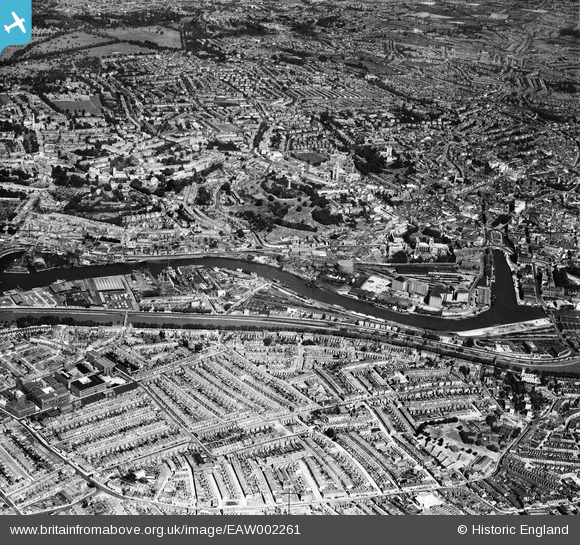
EAW002261 ENGLAND (1946). Brandon Hill, Canon's Marsh and the city, Bristol, 1946
© Copyright OpenStreetMap contributors and licensed by the OpenStreetMap Foundation. 2025. Cartography is licensed as CC BY-SA.
Nearby Images (22)
Details
| Title | [EAW002261] Brandon Hill, Canon's Marsh and the city, Bristol, 1946 |
| Reference | EAW002261 |
| Date | 18-August-1946 |
| Link | |
| Place name | BRISTOL |
| Parish | |
| District | |
| Country | ENGLAND |
| Easting / Northing | 357964, 172531 |
| Longitude / Latitude | -2.604989944876, 51.449712975498 |
| National Grid Reference | ST580725 |
Pins
 gBr |
Tuesday 17th of November 2015 06:53:40 PM | |
 MildBunch |
Tuesday 17th of February 2015 01:44:07 PM | |
 MildBunch |
Tuesday 17th of February 2015 01:42:35 PM | |
 psjones01 |
Wednesday 20th of November 2013 08:41:48 PM |


![[EAW002261] Brandon Hill, Canon's Marsh and the city, Bristol, 1946](http://britainfromabove.org.uk/sites/all/libraries/aerofilms-images/public/100x100/EAW/002/EAW002261.jpg)
![[EAW000701] Anchor Road and the Cathedral Garage looking towards Clifton Wood, Bristol, 1946](http://britainfromabove.org.uk/sites/all/libraries/aerofilms-images/public/100x100/EAW/000/EAW000701.jpg)
![[EAW000705] Canon's Marsh Gas Works, Brandon Hill and environs, Bristol, from the south-east, 1946](http://britainfromabove.org.uk/sites/all/libraries/aerofilms-images/public/100x100/EAW/000/EAW000705.jpg)
![[EAW000700] Canon's Marsh Gas Works and environs, Bristol, 1946](http://britainfromabove.org.uk/sites/all/libraries/aerofilms-images/public/100x100/EAW/000/EAW000700.jpg)
![[EAW000702] Anchor Road and the Cathedral Garage looking towards Bellevue Crescent, 1946](http://britainfromabove.org.uk/sites/all/libraries/aerofilms-images/public/100x100/EAW/000/EAW000702.jpg)
![[EPW001269] Bristol Cathedral and Brandon Hill with the Cabot Tower, 1920](http://britainfromabove.org.uk/sites/all/libraries/aerofilms-images/public/100x100/EPW/001/EPW001269.jpg)
![[EAW000704] Brandon Hill and environs, Bristol, from the south-east, 1946](http://britainfromabove.org.uk/sites/all/libraries/aerofilms-images/public/100x100/EAW/000/EAW000704.jpg)
![[EAW002260] Brandon Hill, Canon's Marsh and the city, Bristol, 1946](http://britainfromabove.org.uk/sites/all/libraries/aerofilms-images/public/100x100/EAW/002/EAW002260.jpg)
![[EAW000699] Brandon Hill, St George's Road and environs, Bristol, 1946](http://britainfromabove.org.uk/sites/all/libraries/aerofilms-images/public/100x100/EAW/000/EAW000699.jpg)
![[EAW000698] Brandon Hill, Bristol, 1946](http://britainfromabove.org.uk/sites/all/libraries/aerofilms-images/public/100x100/EAW/000/EAW000698.jpg)
![[EAW000703] The Cathedral Garage, Brandon Hill and environs, Bristol, 1946](http://britainfromabove.org.uk/sites/all/libraries/aerofilms-images/public/100x100/EAW/000/EAW000703.jpg)
![[EAW002258] Brandon Hill, Canon's Marsh and the city, Bristol, 1946](http://britainfromabove.org.uk/sites/all/libraries/aerofilms-images/public/100x100/EAW/002/EAW002258.jpg)
![[EAW250863] The steam ship SS Great Britain in Great Western Dry Dock, Bristol, 1973](http://britainfromabove.org.uk/sites/all/libraries/aerofilms-images/public/100x100/EAW/250/EAW250863.jpg)
![[EAW033321] Brandon Hill and the city centre, Bristol, from the south, 1950](http://britainfromabove.org.uk/sites/all/libraries/aerofilms-images/public/100x100/EAW/033/EAW033321.jpg)
![[EAW002048] Canon's Marsh, Bristol, 1946](http://britainfromabove.org.uk/sites/all/libraries/aerofilms-images/public/100x100/EAW/002/EAW002048.jpg)
![[EPW005447] St George's Road and Brandon House, Bristol, 1921](http://britainfromabove.org.uk/sites/all/libraries/aerofilms-images/public/100x100/EPW/005/EPW005447.jpg)
![[EPW005449] Fry's building on St George's Road, Bristol, 1921](http://britainfromabove.org.uk/sites/all/libraries/aerofilms-images/public/100x100/EPW/005/EPW005449.jpg)
![[EPW005450] Fry's building on St George's Road, Bristol, 1921](http://britainfromabove.org.uk/sites/all/libraries/aerofilms-images/public/100x100/EPW/005/EPW005450.jpg)
![[EPW005448] Fry's building on St George's Road, Bristol, 1921](http://britainfromabove.org.uk/sites/all/libraries/aerofilms-images/public/100x100/EPW/005/EPW005448.jpg)
![[EPW005451] Fry's building on St George's Road, Bristol, 1921](http://britainfromabove.org.uk/sites/all/libraries/aerofilms-images/public/100x100/EPW/005/EPW005451.jpg)
![[EPW005452] Fry's building on St George's Road, Bristol, 1921](http://britainfromabove.org.uk/sites/all/libraries/aerofilms-images/public/100x100/EPW/005/EPW005452.jpg)
![[EAW033314] Canon's Marsh, Bristol Cathedral and the city, Bristol, from the south, 1950](http://britainfromabove.org.uk/sites/all/libraries/aerofilms-images/public/100x100/EAW/033/EAW033314.jpg)