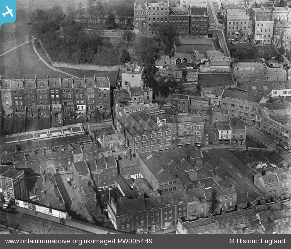
EPW005449 ENGLAND (1921). Fry's building on St George's Road, Bristol, 1921
© Copyright OpenStreetMap contributors and licensed by the OpenStreetMap Foundation. 2024. Cartography is licensed as CC BY-SA.
Nearby Images (32)
Details
| Title | [EPW005449] Fry's building on St George's Road, Bristol, 1921 |
| Reference | EPW005449 |
| Date | 20-March-1921 |
| Link | |
| Place name | BRISTOL |
| Parish | |
| District | |
| Country | ENGLAND |
| Easting / Northing | 358128, 172766 |
| Longitude / Latitude | -2.6026575884361, 51.451838269969 |
| National Grid Reference | ST581728 |
Pins
 Class31 |
Wednesday 10th of October 2012 07:56:52 PM | |
 Class31 |
Monday 8th of October 2012 08:14:12 PM | |
 Class31 |
Monday 8th of October 2012 08:13:40 PM | |
 Class31 |
Monday 8th of October 2012 08:10:42 PM | |
 Class31 |
Monday 8th of October 2012 08:10:10 PM | |
 Class31 |
Monday 8th of October 2012 08:09:44 PM | |
 Class31 |
Monday 8th of October 2012 08:08:08 PM |


![[EPW005449] Fry's building on St George's Road, Bristol, 1921](http://britainfromabove.org.uk/sites/all/libraries/aerofilms-images/public/100x100/EPW/005/EPW005449.jpg)
![[EPW005447] St George's Road and Brandon House, Bristol, 1921](http://britainfromabove.org.uk/sites/all/libraries/aerofilms-images/public/100x100/EPW/005/EPW005447.jpg)
![[EPW005450] Fry's building on St George's Road, Bristol, 1921](http://britainfromabove.org.uk/sites/all/libraries/aerofilms-images/public/100x100/EPW/005/EPW005450.jpg)
![[EPW005451] Fry's building on St George's Road, Bristol, 1921](http://britainfromabove.org.uk/sites/all/libraries/aerofilms-images/public/100x100/EPW/005/EPW005451.jpg)
![[EPW005452] Fry's building on St George's Road, Bristol, 1921](http://britainfromabove.org.uk/sites/all/libraries/aerofilms-images/public/100x100/EPW/005/EPW005452.jpg)
![[EPW005448] Fry's building on St George's Road, Bristol, 1921](http://britainfromabove.org.uk/sites/all/libraries/aerofilms-images/public/100x100/EPW/005/EPW005448.jpg)
![[EAW002258] Brandon Hill, Canon's Marsh and the city, Bristol, 1946](http://britainfromabove.org.uk/sites/all/libraries/aerofilms-images/public/100x100/EAW/002/EAW002258.jpg)
![[EAW050556] City Hall and environs, Bristol, 1953](http://britainfromabove.org.uk/sites/all/libraries/aerofilms-images/public/100x100/EAW/050/EAW050556.jpg)
![[EAW052884] City Hall, the Cathedral Church of The Holy and Undivided Trinity and environs, Bristol, 1953](http://britainfromabove.org.uk/sites/all/libraries/aerofilms-images/public/100x100/EAW/052/EAW052884.jpg)
![[EAW052874] City Hall, the Cathedral Church of The Holy and Undivided Trinity and environs, Bristol, 1953](http://britainfromabove.org.uk/sites/all/libraries/aerofilms-images/public/100x100/EAW/052/EAW052874.jpg)
![[EAW000703] The Cathedral Garage, Brandon Hill and environs, Bristol, 1946](http://britainfromabove.org.uk/sites/all/libraries/aerofilms-images/public/100x100/EAW/000/EAW000703.jpg)
![[EAW000699] Brandon Hill, St George's Road and environs, Bristol, 1946](http://britainfromabove.org.uk/sites/all/libraries/aerofilms-images/public/100x100/EAW/000/EAW000699.jpg)
![[EPW012017] The Cathedral Church of St Augustine, Bristol, 1924. This image has been produced from a print.](http://britainfromabove.org.uk/sites/all/libraries/aerofilms-images/public/100x100/EPW/012/EPW012017.jpg)
![[EAW052883] City Hall, the Cathedral Church of The Holy and Undivided Trinity and environs, Bristol, 1953](http://britainfromabove.org.uk/sites/all/libraries/aerofilms-images/public/100x100/EAW/052/EAW052883.jpg)
![[EAW000698] Brandon Hill, Bristol, 1946](http://britainfromabove.org.uk/sites/all/libraries/aerofilms-images/public/100x100/EAW/000/EAW000698.jpg)
![[EAW052885] City Hall, the Cathedral Church of The Holy and Undivided Trinity and environs, Bristol, 1953](http://britainfromabove.org.uk/sites/all/libraries/aerofilms-images/public/100x100/EAW/052/EAW052885.jpg)
![[EAW000704] Brandon Hill and environs, Bristol, from the south-east, 1946](http://britainfromabove.org.uk/sites/all/libraries/aerofilms-images/public/100x100/EAW/000/EAW000704.jpg)
![[EAW002262] Brandon Hill, Canon's Marsh and the city, Bristol, 1946](http://britainfromabove.org.uk/sites/all/libraries/aerofilms-images/public/100x100/EAW/002/EAW002262.jpg)
![[EAW000702] Anchor Road and the Cathedral Garage looking towards Bellevue Crescent, 1946](http://britainfromabove.org.uk/sites/all/libraries/aerofilms-images/public/100x100/EAW/000/EAW000702.jpg)
![[EAW000705] Canon's Marsh Gas Works, Brandon Hill and environs, Bristol, from the south-east, 1946](http://britainfromabove.org.uk/sites/all/libraries/aerofilms-images/public/100x100/EAW/000/EAW000705.jpg)
![[EAW002259] Brandon Hill, Canon's Marsh and the city, Bristol, 1946](http://britainfromabove.org.uk/sites/all/libraries/aerofilms-images/public/100x100/EAW/002/EAW002259.jpg)
![[EAW000701] Anchor Road and the Cathedral Garage looking towards Clifton Wood, Bristol, 1946](http://britainfromabove.org.uk/sites/all/libraries/aerofilms-images/public/100x100/EAW/000/EAW000701.jpg)
![[EAW002260] Brandon Hill, Canon's Marsh and the city, Bristol, 1946](http://britainfromabove.org.uk/sites/all/libraries/aerofilms-images/public/100x100/EAW/002/EAW002260.jpg)
![[EPW001269] Bristol Cathedral and Brandon Hill with the Cabot Tower, 1920](http://britainfromabove.org.uk/sites/all/libraries/aerofilms-images/public/100x100/EPW/001/EPW001269.jpg)
![[EPW005462] The Cathedral of the Holy and Undivided Trinity, Bristol, 1921](http://britainfromabove.org.uk/sites/all/libraries/aerofilms-images/public/100x100/EPW/005/EPW005462.jpg)
![[EPW005472] The Cathedral of the Holy and Undivided Trinity, Bristol, 1921](http://britainfromabove.org.uk/sites/all/libraries/aerofilms-images/public/100x100/EPW/005/EPW005472.jpg)
![[EPW005473] The Cathedral of the Holy and Undivided Trinity, Bristol, 1921](http://britainfromabove.org.uk/sites/all/libraries/aerofilms-images/public/100x100/EPW/005/EPW005473.jpg)
![[EPW022275] The University of Bristol and Tyndall's Park, Bristol, from the south-east, 1928](http://britainfromabove.org.uk/sites/all/libraries/aerofilms-images/public/100x100/EPW/022/EPW022275.jpg)
![[EAW000700] Canon's Marsh Gas Works and environs, Bristol, 1946](http://britainfromabove.org.uk/sites/all/libraries/aerofilms-images/public/100x100/EAW/000/EAW000700.jpg)
![[EPW008828] The Cathedral Church of St Augustine and environs, Bristol, 1923](http://britainfromabove.org.uk/sites/all/libraries/aerofilms-images/public/100x100/EPW/008/EPW008828.jpg)
![[EAW002045] The Floating Harbour and the city centre, Bristol, 1946. This image has been produced from a print.](http://britainfromabove.org.uk/sites/all/libraries/aerofilms-images/public/100x100/EAW/002/EAW002045.jpg)
![[EAW002261] Brandon Hill, Canon's Marsh and the city, Bristol, 1946](http://britainfromabove.org.uk/sites/all/libraries/aerofilms-images/public/100x100/EAW/002/EAW002261.jpg)