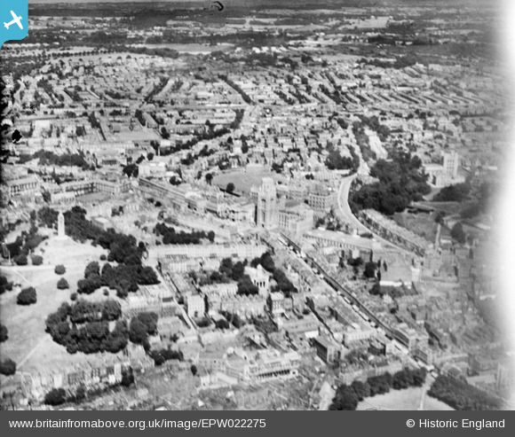
EPW022275 ENGLAND (1928). The University of Bristol and Tyndall's Park, Bristol, from the south-east, 1928
© Copyright OpenStreetMap contributors and licensed by the OpenStreetMap Foundation. 2025. Cartography is licensed as CC BY-SA.
Nearby Images (18)
Details
| Title | [EPW022275] The University of Bristol and Tyndall's Park, Bristol, from the south-east, 1928 |
| Reference | EPW022275 |
| Date | August-1928 |
| Link | |
| Place name | BRISTOL |
| Parish | |
| District | |
| Country | ENGLAND |
| Easting / Northing | 358080, 173013 |
| Longitude / Latitude | -2.6033776836042, 51.454055761013 |
| National Grid Reference | ST581730 |
Pins
 hilary |
Tuesday 29th of December 2015 02:38:05 PM | |
 hilary |
Tuesday 29th of December 2015 02:36:10 PM | |
 hilary |
Tuesday 29th of December 2015 02:35:07 PM | |
 Class31 |
Saturday 19th of January 2013 10:52:19 PM | |
 Class31 |
Saturday 19th of January 2013 10:51:17 PM | |
 Class31 |
Wednesday 11th of July 2012 01:46:38 PM | |
 Class31 |
Wednesday 11th of July 2012 01:46:12 PM | |
 Class31 |
Wednesday 11th of July 2012 01:44:52 PM | |
 Class31 |
Wednesday 11th of July 2012 01:44:27 PM | |
 Class31 |
Wednesday 11th of July 2012 01:44:01 PM | |
 rh8 |
Wednesday 27th of June 2012 12:18:44 AM |


![[EPW022275] The University of Bristol and Tyndall's Park, Bristol, from the south-east, 1928](http://britainfromabove.org.uk/sites/all/libraries/aerofilms-images/public/100x100/EPW/022/EPW022275.jpg)
![[EAW050557] Charlotte Street and environs, Bristol, 1953](http://britainfromabove.org.uk/sites/all/libraries/aerofilms-images/public/100x100/EAW/050/EAW050557.jpg)
![[EPW047091] Brandon Hill, Cabot Tower and the city, Bristol, 1935](http://britainfromabove.org.uk/sites/all/libraries/aerofilms-images/public/100x100/EPW/047/EPW047091.jpg)
![[EPW022270] The University of Bristol and the city, Bristol, from the south-east, 1928](http://britainfromabove.org.uk/sites/all/libraries/aerofilms-images/public/100x100/EPW/022/EPW022270.jpg)
![[EPW033148] The Wills Memorial Building, University of Bristol and environs, Bristol, 1930](http://britainfromabove.org.uk/sites/all/libraries/aerofilms-images/public/100x100/EPW/033/EPW033148.jpg)
![[EPW033151] The Wills Memorial Building, University of Bristol and environs, Bristol, 1930](http://britainfromabove.org.uk/sites/all/libraries/aerofilms-images/public/100x100/EPW/033/EPW033151.jpg)
![[EPW022271] The University of Bristol Tower, Bristol, 1928](http://britainfromabove.org.uk/sites/all/libraries/aerofilms-images/public/100x100/EPW/022/EPW022271.jpg)
![[EAW002259] Brandon Hill, Canon's Marsh and the city, Bristol, 1946](http://britainfromabove.org.uk/sites/all/libraries/aerofilms-images/public/100x100/EAW/002/EAW002259.jpg)
![[EAW050556] City Hall and environs, Bristol, 1953](http://britainfromabove.org.uk/sites/all/libraries/aerofilms-images/public/100x100/EAW/050/EAW050556.jpg)
![[EPW011998] The Wills Memorial Building under construction, Bristol, 1924. This image has been produced from a copy-negative.](http://britainfromabove.org.uk/sites/all/libraries/aerofilms-images/public/100x100/EPW/011/EPW011998.jpg)
![[EPW033150] The Wills Memorial Building, Museum, University of Bristol and environs, Bristol, 1930](http://britainfromabove.org.uk/sites/all/libraries/aerofilms-images/public/100x100/EPW/033/EPW033150.jpg)
![[EPW005449] Fry's building on St George's Road, Bristol, 1921](http://britainfromabove.org.uk/sites/all/libraries/aerofilms-images/public/100x100/EPW/005/EPW005449.jpg)
![[EPW005451] Fry's building on St George's Road, Bristol, 1921](http://britainfromabove.org.uk/sites/all/libraries/aerofilms-images/public/100x100/EPW/005/EPW005451.jpg)
![[EPW005448] Fry's building on St George's Road, Bristol, 1921](http://britainfromabove.org.uk/sites/all/libraries/aerofilms-images/public/100x100/EPW/005/EPW005448.jpg)
![[EPW005452] Fry's building on St George's Road, Bristol, 1921](http://britainfromabove.org.uk/sites/all/libraries/aerofilms-images/public/100x100/EPW/005/EPW005452.jpg)
![[EAW015781] Tyndall's Park, Bristol, 1948. This image has been produced from a print.](http://britainfromabove.org.uk/sites/all/libraries/aerofilms-images/public/100x100/EAW/015/EAW015781.jpg)
![[EAW052883] City Hall, the Cathedral Church of The Holy and Undivided Trinity and environs, Bristol, 1953](http://britainfromabove.org.uk/sites/all/libraries/aerofilms-images/public/100x100/EAW/052/EAW052883.jpg)
![[EPW012017] The Cathedral Church of St Augustine, Bristol, 1924. This image has been produced from a print.](http://britainfromabove.org.uk/sites/all/libraries/aerofilms-images/public/100x100/EPW/012/EPW012017.jpg)