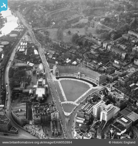
EAW052884 ENGLAND (1953). City Hall, the Cathedral Church of The Holy and Undivided Trinity and environs, Bristol, 1953
© Copyright OpenStreetMap contributors and licensed by the OpenStreetMap Foundation. 2025. Cartography is licensed as CC BY-SA.
Nearby Images (27)
Details
| Title | [EAW052884] City Hall, the Cathedral Church of The Holy and Undivided Trinity and environs, Bristol, 1953 |
| Reference | EAW052884 |
| Date | 16-October-1953 |
| Link | |
| Place name | BRISTOL |
| Parish | |
| District | |
| Country | ENGLAND |
| Easting / Northing | 358265, 172752 |
| Longitude / Latitude | -2.6006842319908, 51.451722498596 |
| National Grid Reference | ST583728 |
Pins
Be the first to add a comment to this image!


![[EAW052884] City Hall, the Cathedral Church of The Holy and Undivided Trinity and environs, Bristol, 1953](http://britainfromabove.org.uk/sites/all/libraries/aerofilms-images/public/100x100/EAW/052/EAW052884.jpg)
![[EAW052874] City Hall, the Cathedral Church of The Holy and Undivided Trinity and environs, Bristol, 1953](http://britainfromabove.org.uk/sites/all/libraries/aerofilms-images/public/100x100/EAW/052/EAW052874.jpg)
![[EPW012017] The Cathedral Church of St Augustine, Bristol, 1924. This image has been produced from a print.](http://britainfromabove.org.uk/sites/all/libraries/aerofilms-images/public/100x100/EPW/012/EPW012017.jpg)
![[EAW052883] City Hall, the Cathedral Church of The Holy and Undivided Trinity and environs, Bristol, 1953](http://britainfromabove.org.uk/sites/all/libraries/aerofilms-images/public/100x100/EAW/052/EAW052883.jpg)
![[EAW052885] City Hall, the Cathedral Church of The Holy and Undivided Trinity and environs, Bristol, 1953](http://britainfromabove.org.uk/sites/all/libraries/aerofilms-images/public/100x100/EAW/052/EAW052885.jpg)
![[EAW050556] City Hall and environs, Bristol, 1953](http://britainfromabove.org.uk/sites/all/libraries/aerofilms-images/public/100x100/EAW/050/EAW050556.jpg)
![[EPW005448] Fry's building on St George's Road, Bristol, 1921](http://britainfromabove.org.uk/sites/all/libraries/aerofilms-images/public/100x100/EPW/005/EPW005448.jpg)
![[EPW005452] Fry's building on St George's Road, Bristol, 1921](http://britainfromabove.org.uk/sites/all/libraries/aerofilms-images/public/100x100/EPW/005/EPW005452.jpg)
![[EPW005450] Fry's building on St George's Road, Bristol, 1921](http://britainfromabove.org.uk/sites/all/libraries/aerofilms-images/public/100x100/EPW/005/EPW005450.jpg)
![[EPW005451] Fry's building on St George's Road, Bristol, 1921](http://britainfromabove.org.uk/sites/all/libraries/aerofilms-images/public/100x100/EPW/005/EPW005451.jpg)
![[EPW005473] The Cathedral of the Holy and Undivided Trinity, Bristol, 1921](http://britainfromabove.org.uk/sites/all/libraries/aerofilms-images/public/100x100/EPW/005/EPW005473.jpg)
![[EPW005462] The Cathedral of the Holy and Undivided Trinity, Bristol, 1921](http://britainfromabove.org.uk/sites/all/libraries/aerofilms-images/public/100x100/EPW/005/EPW005462.jpg)
![[EPW005472] The Cathedral of the Holy and Undivided Trinity, Bristol, 1921](http://britainfromabove.org.uk/sites/all/libraries/aerofilms-images/public/100x100/EPW/005/EPW005472.jpg)
![[EPW005447] St George's Road and Brandon House, Bristol, 1921](http://britainfromabove.org.uk/sites/all/libraries/aerofilms-images/public/100x100/EPW/005/EPW005447.jpg)
![[EPW005449] Fry's building on St George's Road, Bristol, 1921](http://britainfromabove.org.uk/sites/all/libraries/aerofilms-images/public/100x100/EPW/005/EPW005449.jpg)
![[EPW008828] The Cathedral Church of St Augustine and environs, Bristol, 1923](http://britainfromabove.org.uk/sites/all/libraries/aerofilms-images/public/100x100/EPW/008/EPW008828.jpg)
![[EAW002262] Brandon Hill, Canon's Marsh and the city, Bristol, 1946](http://britainfromabove.org.uk/sites/all/libraries/aerofilms-images/public/100x100/EAW/002/EAW002262.jpg)
![[EAW002259] Brandon Hill, Canon's Marsh and the city, Bristol, 1946](http://britainfromabove.org.uk/sites/all/libraries/aerofilms-images/public/100x100/EAW/002/EAW002259.jpg)
![[EAW002045] The Floating Harbour and the city centre, Bristol, 1946. This image has been produced from a print.](http://britainfromabove.org.uk/sites/all/libraries/aerofilms-images/public/100x100/EAW/002/EAW002045.jpg)
![[EAW002046] The Floating Harbour and the city centre, Bristol, 1946. This image has been produced from a print.](http://britainfromabove.org.uk/sites/all/libraries/aerofilms-images/public/100x100/EAW/002/EAW002046.jpg)
![[EPR000106] The Cathedral of The Holy and Undivided Trinity and the city centre, Bristol, 1934](http://britainfromabove.org.uk/sites/all/libraries/aerofilms-images/public/100x100/EPR/000/EPR000106.jpg)
![[EPW033502] Canon's Marsh, Bristol, 1930](http://britainfromabove.org.uk/sites/all/libraries/aerofilms-images/public/100x100/EPW/033/EPW033502.jpg)
![[EAW002258] Brandon Hill, Canon's Marsh and the city, Bristol, 1946](http://britainfromabove.org.uk/sites/all/libraries/aerofilms-images/public/100x100/EAW/002/EAW002258.jpg)
![[EAW000703] The Cathedral Garage, Brandon Hill and environs, Bristol, 1946](http://britainfromabove.org.uk/sites/all/libraries/aerofilms-images/public/100x100/EAW/000/EAW000703.jpg)
![[EAW002048] Canon's Marsh, Bristol, 1946](http://britainfromabove.org.uk/sites/all/libraries/aerofilms-images/public/100x100/EAW/002/EAW002048.jpg)
![[EAW000705] Canon's Marsh Gas Works, Brandon Hill and environs, Bristol, from the south-east, 1946](http://britainfromabove.org.uk/sites/all/libraries/aerofilms-images/public/100x100/EAW/000/EAW000705.jpg)
![[EAW000700] Canon's Marsh Gas Works and environs, Bristol, 1946](http://britainfromabove.org.uk/sites/all/libraries/aerofilms-images/public/100x100/EAW/000/EAW000700.jpg)