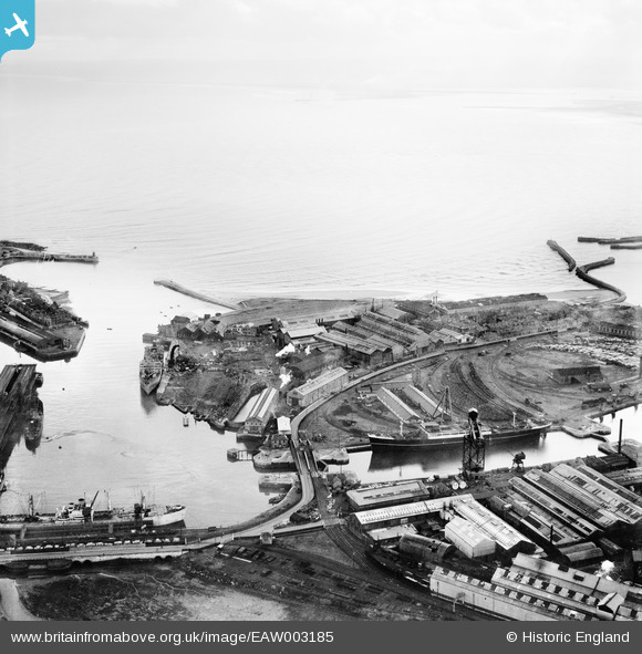
EAW003185 ENGLAND (1946). The Old Harbour, the North Basin and the Hartlepool Engine Works, Hartlepool, from the north-west, 1946
© Copyright OpenStreetMap contributors and licensed by the OpenStreetMap Foundation. 2025. Cartography is licensed as CC BY-SA.
Nearby Images (13)
Details
| Title | [EAW003185] The Old Harbour, the North Basin and the Hartlepool Engine Works, Hartlepool, from the north-west, 1946 |
| Reference | EAW003185 |
| Date | 23-October-1946 |
| Link | |
| Place name | HARTLEPOOL |
| Parish | |
| District | |
| Country | ENGLAND |
| Easting / Northing | 451908, 533939 |
| Longitude / Latitude | -1.1944960887895, 54.697694707504 |
| National Grid Reference | NZ519339 |


![[EAW003185] The Old Harbour, the North Basin and the Hartlepool Engine Works, Hartlepool, from the north-west, 1946](http://britainfromabove.org.uk/sites/all/libraries/aerofilms-images/public/100x100/EAW/003/EAW003185.jpg)
![[EAW003186] The Old Harbour, the Hartlepool Engine Works and Hartlepool Bay, Hartlepool, from the north-west, 1946](http://britainfromabove.org.uk/sites/all/libraries/aerofilms-images/public/100x100/EAW/003/EAW003186.jpg)
![[EAW003191] The Hartlepool Engine Works and the surrounding harbour, Hartlepool, from the north, 1946](http://britainfromabove.org.uk/sites/all/libraries/aerofilms-images/public/100x100/EAW/003/EAW003191.jpg)
![[EPW010608] Central Marine Engine Works and environs, Hartlepool, 1924](http://britainfromabove.org.uk/sites/all/libraries/aerofilms-images/public/100x100/EPW/010/EPW010608.jpg)
![[EAW007972] The Old Harbour and the docks, Hartlepool, 1947](http://britainfromabove.org.uk/sites/all/libraries/aerofilms-images/public/100x100/EAW/007/EAW007972.jpg)
![[EAW003192] The Hartlepool Engine Works, Jackson Dock and a smog covered town centre, Hartlepool, from the north, 1946](http://britainfromabove.org.uk/sites/all/libraries/aerofilms-images/public/100x100/EAW/003/EAW003192.jpg)
![[EPW054633] The Richardsons, Westgarth and Co Hartlepool Engine Works alongside Old Harbour and North Basin, Hartlepool, 1937. This image has been produced from a copy-negative.](http://britainfromabove.org.uk/sites/all/libraries/aerofilms-images/public/100x100/EPW/054/EPW054633.jpg)
![[EAW003203] The Hartlepool Engine Works and the West Harbour, Hartlepool, 1946](http://britainfromabove.org.uk/sites/all/libraries/aerofilms-images/public/100x100/EAW/003/EAW003203.jpg)
![[EPW054634] The Richardsons, Westgarth and Co Hartlepool Engine Works between Old Harbour and West Harbour, Hartlepool, 1937. This image has been produced from a copy-negative.](http://britainfromabove.org.uk/sites/all/libraries/aerofilms-images/public/100x100/EPW/054/EPW054634.jpg)
![[EPW054635] The Richardsons, Westgarth and Co Hartlepool Engine Works alongside Old Harbour, Hartlepool, 1937. This image has been produced from a print.](http://britainfromabove.org.uk/sites/all/libraries/aerofilms-images/public/100x100/EPW/054/EPW054635.jpg)
![[EPW010609] Central Marine Engine Works and environs, Hartlepool, 1924](http://britainfromabove.org.uk/sites/all/libraries/aerofilms-images/public/100x100/EPW/010/EPW010609.jpg)
![[EAW003190] The Hartlepool Engine Works and the surrounding harbour, Hartlepool, 1946](http://britainfromabove.org.uk/sites/all/libraries/aerofilms-images/public/100x100/EAW/003/EAW003190.jpg)
![[EAW003187] The Old Harbour, the Hartlepool Engine Works and Hartlepool Bay, Hartlepool, 1946](http://britainfromabove.org.uk/sites/all/libraries/aerofilms-images/public/100x100/EAW/003/EAW003187.jpg)
