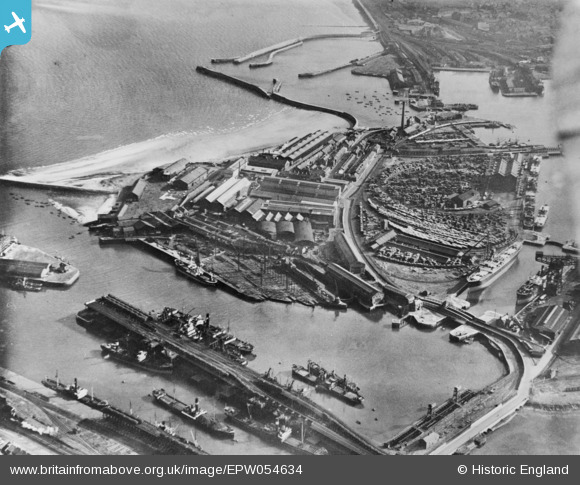
EPW054634 ENGLAND (1937). The Richardsons, Westgarth and Co Hartlepool Engine Works between Old Harbour and West Harbour, Hartlepool, 1937. This image has been produced from a copy-negative.
© Copyright OpenStreetMap contributors and licensed by the OpenStreetMap Foundation. 2025. Cartography is licensed as CC BY-SA.
Nearby Images (23)
Details
| Title | [EPW054634] The Richardsons, Westgarth and Co Hartlepool Engine Works between Old Harbour and West Harbour, Hartlepool, 1937. This image has been produced from a copy-negative. |
| Reference | EPW054634 |
| Date | 30-July-1937 |
| Link | |
| Place name | HARTLEPOOL |
| Parish | |
| District | |
| Country | ENGLAND |
| Easting / Northing | 452065, 533756 |
| Longitude / Latitude | -1.1920927225754, 54.696033913897 |
| National Grid Reference | NZ521338 |
Pins
Be the first to add a comment to this image!


![[EPW054634] The Richardsons, Westgarth and Co Hartlepool Engine Works between Old Harbour and West Harbour, Hartlepool, 1937. This image has been produced from a copy-negative.](http://britainfromabove.org.uk/sites/all/libraries/aerofilms-images/public/100x100/EPW/054/EPW054634.jpg)
![[EPW054633] The Richardsons, Westgarth and Co Hartlepool Engine Works alongside Old Harbour and North Basin, Hartlepool, 1937. This image has been produced from a copy-negative.](http://britainfromabove.org.uk/sites/all/libraries/aerofilms-images/public/100x100/EPW/054/EPW054633.jpg)
![[EPW054635] The Richardsons, Westgarth and Co Hartlepool Engine Works alongside Old Harbour, Hartlepool, 1937. This image has been produced from a print.](http://britainfromabove.org.uk/sites/all/libraries/aerofilms-images/public/100x100/EPW/054/EPW054635.jpg)
![[EAW003203] The Hartlepool Engine Works and the West Harbour, Hartlepool, 1946](http://britainfromabove.org.uk/sites/all/libraries/aerofilms-images/public/100x100/EAW/003/EAW003203.jpg)
![[EAW003187] The Old Harbour, the Hartlepool Engine Works and Hartlepool Bay, Hartlepool, 1946](http://britainfromabove.org.uk/sites/all/libraries/aerofilms-images/public/100x100/EAW/003/EAW003187.jpg)
![[EAW003190] The Hartlepool Engine Works and the surrounding harbour, Hartlepool, 1946](http://britainfromabove.org.uk/sites/all/libraries/aerofilms-images/public/100x100/EAW/003/EAW003190.jpg)
![[EPW054630] The Richardsons, Westgarth and Co Hartlepool Engine Works alongside Old Harbour and North Basin, Hartlepool, 1937. This image has been produced from a print.](http://britainfromabove.org.uk/sites/all/libraries/aerofilms-images/public/100x100/EPW/054/EPW054630.jpg)
![[EAW003193] The Hartlepool Engine Works, Jackson Dock and a smog covered town centre, Hartlepool, 1946](http://britainfromabove.org.uk/sites/all/libraries/aerofilms-images/public/100x100/EAW/003/EAW003193.jpg)
![[EPW054631] The Richardsons, Westgarth and Co Hartlepool Engine Works, Hartlepool, 1937. This image has been produced from a print.](http://britainfromabove.org.uk/sites/all/libraries/aerofilms-images/public/100x100/EPW/054/EPW054631.jpg)
![[EPW054577] Richardsons, Westgarth and Co Hartlepool Engine Works, Hartlepool, 1937](http://britainfromabove.org.uk/sites/all/libraries/aerofilms-images/public/100x100/EPW/054/EPW054577.jpg)
![[EAW003192] The Hartlepool Engine Works, Jackson Dock and a smog covered town centre, Hartlepool, from the north, 1946](http://britainfromabove.org.uk/sites/all/libraries/aerofilms-images/public/100x100/EAW/003/EAW003192.jpg)
![[EAW003200] The Hartlepool Engine Works and the Old Harbour, Hartlepool, 1946](http://britainfromabove.org.uk/sites/all/libraries/aerofilms-images/public/100x100/EAW/003/EAW003200.jpg)
![[EAW003201] The Hartlepool Engine Works and the surrounding docks, Hartlepool, from the east, 1946](http://britainfromabove.org.uk/sites/all/libraries/aerofilms-images/public/100x100/EAW/003/EAW003201.jpg)
![[EAW003199] The Hartlepool Engine Works and the Old Harbour, Hartlepool, 1946](http://britainfromabove.org.uk/sites/all/libraries/aerofilms-images/public/100x100/EAW/003/EAW003199.jpg)
![[EAW003191] The Hartlepool Engine Works and the surrounding harbour, Hartlepool, from the north, 1946](http://britainfromabove.org.uk/sites/all/libraries/aerofilms-images/public/100x100/EAW/003/EAW003191.jpg)
![[EPW054636] The Richardsons, Westgarth and Co Hartlepool Engine Works alongside Old Harbour and Central Dock, Hartlepool, 1937. This image has been produced from a print.](http://britainfromabove.org.uk/sites/all/libraries/aerofilms-images/public/100x100/EPW/054/EPW054636.jpg)
![[EAW003186] The Old Harbour, the Hartlepool Engine Works and Hartlepool Bay, Hartlepool, from the north-west, 1946](http://britainfromabove.org.uk/sites/all/libraries/aerofilms-images/public/100x100/EAW/003/EAW003186.jpg)
![[EAW003189] The Hartlepool Engine Works and the surrounding harbour, Hartlepool, 1946](http://britainfromabove.org.uk/sites/all/libraries/aerofilms-images/public/100x100/EAW/003/EAW003189.jpg)
![[EAW007973] The Headland, the Old Harbour and the docks, Hartlepool, 1947](http://britainfromabove.org.uk/sites/all/libraries/aerofilms-images/public/100x100/EAW/007/EAW007973.jpg)
![[EAW003204] The Hartlepool Engine Works, Central Dock and the surrounding area, Hartlepool, from the east, 1946](http://britainfromabove.org.uk/sites/all/libraries/aerofilms-images/public/100x100/EAW/003/EAW003204.jpg)
![[EAW003197] The Hartlepool Engine Works and Hartlepool Bay, Hartlepool, 1946](http://britainfromabove.org.uk/sites/all/libraries/aerofilms-images/public/100x100/EAW/003/EAW003197.jpg)
![[EAW003185] The Old Harbour, the North Basin and the Hartlepool Engine Works, Hartlepool, from the north-west, 1946](http://britainfromabove.org.uk/sites/all/libraries/aerofilms-images/public/100x100/EAW/003/EAW003185.jpg)
![[EAW003194] The Hartlepool Engine Works, Central Dock and the surrounding area, Hartlepool, from the east, 1946](http://britainfromabove.org.uk/sites/all/libraries/aerofilms-images/public/100x100/EAW/003/EAW003194.jpg)