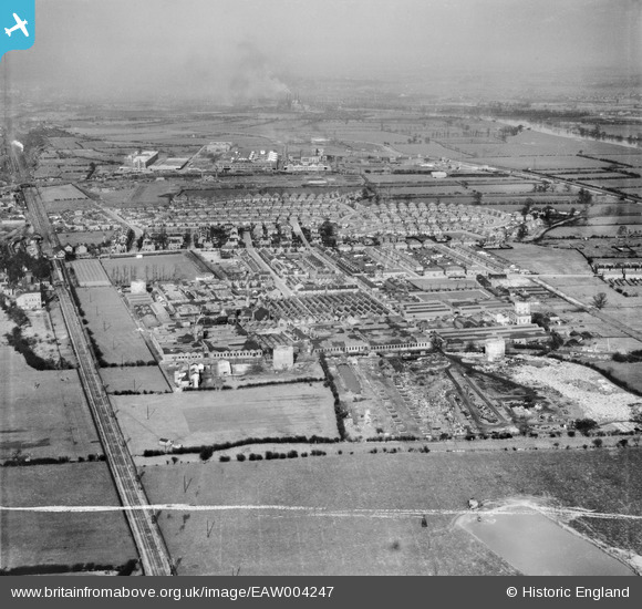
EAW004247 ENGLAND (1947). The British Ericsson Telephone Works, Rylands Estate and environs, Beeston, from the south-west, 1947. This image was marked by Aerofilms Ltd for photo editing.
© Copyright OpenStreetMap contributors and licensed by the OpenStreetMap Foundation. 2025. Cartography is licensed as CC BY-SA.
Nearby Images (32)
Details
| Title | [EAW004247] The British Ericsson Telephone Works, Rylands Estate and environs, Beeston, from the south-west, 1947. This image was marked by Aerofilms Ltd for photo editing. |
| Reference | EAW004247 |
| Date | 9-April-1947 |
| Link | |
| Place name | BEESTON |
| Parish | |
| District | |
| Country | ENGLAND |
| Easting / Northing | 453219, 335728 |
| Longitude / Latitude | -1.2084448028048, 52.916016252813 |
| National Grid Reference | SK532357 |
Pins
 Sparky |
Thursday 28th of September 2017 10:39:03 PM | |
 Tony |
Saturday 9th of November 2013 09:12:15 AM |


![[EAW004247] The British Ericsson Telephone Works, Rylands Estate and environs, Beeston, from the south-west, 1947. This image was marked by Aerofilms Ltd for photo editing.](http://britainfromabove.org.uk/sites/all/libraries/aerofilms-images/public/100x100/EAW/004/EAW004247.jpg)
![[EAW006377] The Ericsson Telephone Works, Rylands, 1947. This image was marked by Aerofilms Ltd for photo editing.](http://britainfromabove.org.uk/sites/all/libraries/aerofilms-images/public/100x100/EAW/006/EAW006377.jpg)
![[EAW005001] The Ericsson Telephone Works and the residential area surrounding Beech Avenue, Rylands, from the south-west, 1947](http://britainfromabove.org.uk/sites/all/libraries/aerofilms-images/public/100x100/EAW/005/EAW005001.jpg)
![[EPW052431] The British Ericsson Telephone Works and environs, Beeston, 1937. This image has been produced from a copy-negative.](http://britainfromabove.org.uk/sites/all/libraries/aerofilms-images/public/100x100/EPW/052/EPW052431.jpg)
![[EPW053166] Ericsson Telephones Ltd Telephone Works, Rylands, 1937](http://britainfromabove.org.uk/sites/all/libraries/aerofilms-images/public/100x100/EPW/053/EPW053166.jpg)
![[EAW005005] The Ericsson Telephone Works, housing off Trent Road and the Chilwell Manor Golf Course, Rylands, 1947](http://britainfromabove.org.uk/sites/all/libraries/aerofilms-images/public/100x100/EAW/005/EAW005005.jpg)
![[EAW006382] The Ericsson Telephone Works and the surrounding residential area, Rylands, 1947. This image was marked by Aerofilms Ltd for photo editing.](http://britainfromabove.org.uk/sites/all/libraries/aerofilms-images/public/100x100/EAW/006/EAW006382.jpg)
![[EAW004242] The British Ericsson Telephone Works and environs, Beeston, 1947. This image was marked by Aerofilms Ltd for photo editing.](http://britainfromabove.org.uk/sites/all/libraries/aerofilms-images/public/100x100/EAW/004/EAW004242.jpg)
![[EAW005000] The Ericsson Telephone Works and the residential area surrounding Beech Avenue, Rylands, from the west, 1947](http://britainfromabove.org.uk/sites/all/libraries/aerofilms-images/public/100x100/EAW/005/EAW005000.jpg)
![[EAW006376] The Ericsson Telephone Works and the surrounding residential area, Rylands, 1947. This image was marked by Aerofilms Ltd for photo editing.](http://britainfromabove.org.uk/sites/all/libraries/aerofilms-images/public/100x100/EAW/006/EAW006376.jpg)
![[EAW005004] The Ericsson Telephone Works, Rylands, 1947](http://britainfromabove.org.uk/sites/all/libraries/aerofilms-images/public/100x100/EAW/005/EAW005004.jpg)
![[EAW004244] The British Ericsson Telephone Works and environs, Beeston, from the north-west, 1947](http://britainfromabove.org.uk/sites/all/libraries/aerofilms-images/public/100x100/EAW/004/EAW004244.jpg)
![[EAW006381] The Ericsson Telephone Works and the surrounding residential area, Rylands, 1947. This image was marked by Aerofilms Ltd for photo editing.](http://britainfromabove.org.uk/sites/all/libraries/aerofilms-images/public/100x100/EAW/006/EAW006381.jpg)
![[EPW053164] Ericsson Telephones Ltd Telephone Works, Rylands, 1937](http://britainfromabove.org.uk/sites/all/libraries/aerofilms-images/public/100x100/EPW/053/EPW053164.jpg)
![[EAW004243] The British Ericsson Telephone Works, Rylands Estate and environs, Beeston, from the west, 1947](http://britainfromabove.org.uk/sites/all/libraries/aerofilms-images/public/100x100/EAW/004/EAW004243.jpg)
![[EPW053168] Ericsson Telephones Ltd Telephone Works, Rylands, 1937](http://britainfromabove.org.uk/sites/all/libraries/aerofilms-images/public/100x100/EPW/053/EPW053168.jpg)
![[EAW004249] The British Ericsson Telephone Works and environs, Beeston, from the south-west, 1947](http://britainfromabove.org.uk/sites/all/libraries/aerofilms-images/public/100x100/EAW/004/EAW004249.jpg)
![[EPW053167] Ericsson Telephones Ltd Telephone Works, Rylands, 1937](http://britainfromabove.org.uk/sites/all/libraries/aerofilms-images/public/100x100/EPW/053/EPW053167.jpg)
![[EAW004239] The British Ericsson Telephone Works, Rylands Estate and environs, Beeston, from the south-west, 1947. This image was marked by Aerofilms Ltd for photo editing.](http://britainfromabove.org.uk/sites/all/libraries/aerofilms-images/public/100x100/EAW/004/EAW004239.jpg)
![[EPW053169] Ericsson Telephones Ltd Telephone Works, Rylands, 1937](http://britainfromabove.org.uk/sites/all/libraries/aerofilms-images/public/100x100/EPW/053/EPW053169.jpg)
![[EPW052424] The British Ericsson Telephone Works and environs, Beeston, 1937. This image has been produced from a copy-negative.](http://britainfromabove.org.uk/sites/all/libraries/aerofilms-images/public/100x100/EPW/052/EPW052424.jpg)
![[EAW004240] The British Ericsson Telephone Works and environs, Beeston, from the south, 1947. This image was marked by Aerofilms Ltd for photo editing.](http://britainfromabove.org.uk/sites/all/libraries/aerofilms-images/public/100x100/EAW/004/EAW004240.jpg)
![[EAW006380] The Ericsson Telephone Works and the surrounding residential area, Rylands, 1947. This image was marked by Aerofilms Ltd for photo editing.](http://britainfromabove.org.uk/sites/all/libraries/aerofilms-images/public/100x100/EAW/006/EAW006380.jpg)
![[EAW006378] The Ericsson Telephone Works, Rylands, 1947. This image was marked by Aerofilms Ltd for photo editing.](http://britainfromabove.org.uk/sites/all/libraries/aerofilms-images/public/100x100/EAW/006/EAW006378.jpg)
![[EAW004246] The British Ericsson Telephone Works, Rylands Estate and environs, Beeston, from the west, 1947](http://britainfromabove.org.uk/sites/all/libraries/aerofilms-images/public/100x100/EAW/004/EAW004246.jpg)
![[EAW004245] The British Ericsson Telephone Works, Rylands Estate and environs, Beeston, from the north-west, 1947](http://britainfromabove.org.uk/sites/all/libraries/aerofilms-images/public/100x100/EAW/004/EAW004245.jpg)
![[EAW006383] The Ericsson Telephone Works and the surrounding residential area, Rylands, 1947. This image was marked by Aerofilms Ltd for photo editing.](http://britainfromabove.org.uk/sites/all/libraries/aerofilms-images/public/100x100/EAW/006/EAW006383.jpg)
![[EAW005002] The Ericsson Telephone Works and the residential area surrounding Beech Avenue, Rylands, from the south-west, 1947](http://britainfromabove.org.uk/sites/all/libraries/aerofilms-images/public/100x100/EAW/005/EAW005002.jpg)
![[EAW005006] The Ericsson Telephone Works and the residential area surrounding Beech Avenue, Rylands, from the west, 1947](http://britainfromabove.org.uk/sites/all/libraries/aerofilms-images/public/100x100/EAW/005/EAW005006.jpg)
![[EAW012085] The Ericsson Telephone Works, Rylands, 1947](http://britainfromabove.org.uk/sites/all/libraries/aerofilms-images/public/100x100/EAW/012/EAW012085.jpg)
![[EAW006379] The Ericsson Telephone Works and the surrounding residential area, Rylands, 1947. This image was marked by Aerofilms Ltd for photo editing.](http://britainfromabove.org.uk/sites/all/libraries/aerofilms-images/public/100x100/EAW/006/EAW006379.jpg)
![[EAW004241] The British Ericsson Telephone Works and environs, Beeston, from the south-east, 1947. This image was marked by Aerofilms Ltd for photo editing.](http://britainfromabove.org.uk/sites/all/libraries/aerofilms-images/public/100x100/EAW/004/EAW004241.jpg)