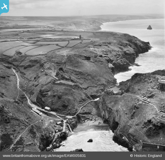
EAW005831 ENGLAND (1947). Archaeological remains on The Island and mainland looking towards the Church of St Materiana, Tintagel, from the north, 1947
© Copyright OpenStreetMap contributors and licensed by the OpenStreetMap Foundation. 2025. Cartography is licensed as CC BY-SA.
Nearby Images (16)
Details
| Title | [EAW005831] Archaeological remains on The Island and mainland looking towards the Church of St Materiana, Tintagel, from the north, 1947 |
| Reference | EAW005831 |
| Date | 18-May-1947 |
| Link | |
| Place name | TINTAGEL |
| Parish | TINTAGEL |
| District | |
| Country | ENGLAND |
| Easting / Northing | 205135, 88989 |
| Longitude / Latitude | -4.7578592872979, 50.667331299105 |
| National Grid Reference | SX051890 |


![[EAW005831] Archaeological remains on The Island and mainland looking towards the Church of St Materiana, Tintagel, from the north, 1947](http://britainfromabove.org.uk/sites/all/libraries/aerofilms-images/public/100x100/EAW/005/EAW005831.jpg)
![[EAW005829] Archaeological remains on The Island and mainland, Tintagel, 1947. This image has been produced from a print.](http://britainfromabove.org.uk/sites/all/libraries/aerofilms-images/public/100x100/EAW/005/EAW005829.jpg)
![[EAW031045] Merlin's Cave and the remains of Tintagel Castle, Tintagel, 1950](http://britainfromabove.org.uk/sites/all/libraries/aerofilms-images/public/100x100/EAW/031/EAW031045.jpg)
![[EAW031019] Hotel Camelot and the surrounding area, Tintagel, from the west, 1950. This image was marked by Aerofilms Ltd for photo editing.](http://britainfromabove.org.uk/sites/all/libraries/aerofilms-images/public/100x100/EAW/031/EAW031019.jpg)
![[EAW031042] King Arthur's Castle Hotel and Tintagel Island, Tintagel, 1950](http://britainfromabove.org.uk/sites/all/libraries/aerofilms-images/public/100x100/EAW/031/EAW031042.jpg)
![[EAW031044] Merlin's Cave and the remains of Tintagel Castle, Tintagel, 1950](http://britainfromabove.org.uk/sites/all/libraries/aerofilms-images/public/100x100/EAW/031/EAW031044.jpg)
![[EAW031015] Hotel Camelot, King Arthur's Castle Hotel and Tintagel Island, Tintagel, 1950. This image was marked by Aerofilms Ltd for photo editing.](http://britainfromabove.org.uk/sites/all/libraries/aerofilms-images/public/100x100/EAW/031/EAW031015.jpg)
![[EAW005833] Archaeological remains on The Island and mainland, Tintagel, 1947](http://britainfromabove.org.uk/sites/all/libraries/aerofilms-images/public/100x100/EAW/005/EAW005833.jpg)
![[EAW005828] Archaeological remains on The Island and mainland, Tintagel, 1947. This image has been produced from a copy-negative.](http://britainfromabove.org.uk/sites/all/libraries/aerofilms-images/public/100x100/EAW/005/EAW005828.jpg)
![[EAW005832] Archaeological remains on The Island and mainland, Tintagel, 1947. This image has been produced from a print.](http://britainfromabove.org.uk/sites/all/libraries/aerofilms-images/public/100x100/EAW/005/EAW005832.jpg)
![[EAW031043] The remains of Tintagel Castle, Tintagel, 1950](http://britainfromabove.org.uk/sites/all/libraries/aerofilms-images/public/100x100/EAW/031/EAW031043.jpg)
![[EAW005830] Archaeological remains on The Island and mainland, Tintagel, from the north, 1947. This image has been produced from a print.](http://britainfromabove.org.uk/sites/all/libraries/aerofilms-images/public/100x100/EAW/005/EAW005830.jpg)
![[EAW031013] Hotel Camelot and Tintagel Island, Tintagel, 1950. This image was marked by Aerofilms Ltd for photo editing.](http://britainfromabove.org.uk/sites/all/libraries/aerofilms-images/public/100x100/EAW/031/EAW031013.jpg)
![[EAW031046] Tintagel Island, Tintagel, 1950](http://britainfromabove.org.uk/sites/all/libraries/aerofilms-images/public/100x100/EAW/031/EAW031046.jpg)
![[EAW020264] The Island and Barras Nose, Tintagel, 1948. This image has been produced from a damaged negative.](http://britainfromabove.org.uk/sites/all/libraries/aerofilms-images/public/100x100/EAW/020/EAW020264.jpg)
![[EAW031041] Tintagel Island, Tintagel, 1950](http://britainfromabove.org.uk/sites/all/libraries/aerofilms-images/public/100x100/EAW/031/EAW031041.jpg)
