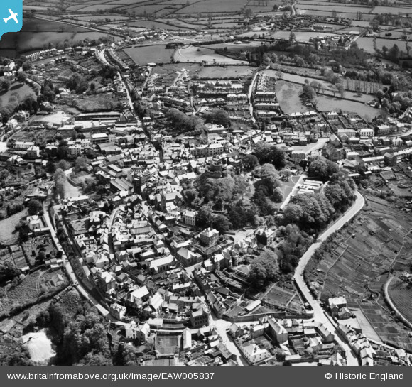
EAW005837 ENGLAND (1947). The castle and town, Launceston, 1947
© Copyright OpenStreetMap contributors and licensed by the OpenStreetMap Foundation. 2024. Cartography is licensed as CC BY-SA.
Nearby Images (17)
Details
| Title | [EAW005837] The castle and town, Launceston, 1947 |
| Reference | EAW005837 |
| Date | 18-May-1947 |
| Link | |
| Place name | LAUNCESTON |
| Parish | LAUNCESTON |
| District | |
| Country | ENGLAND |
| Easting / Northing | 233129, 84665 |
| Longitude / Latitude | -4.3601094476843, 50.637173763944 |
| National Grid Reference | SX331847 |
Pins
 CornwallPhil |
Friday 25th of July 2014 09:56:57 PM | |
fascinating story |
 Al |
Wednesday 13th of August 2014 09:43:44 AM |
 CornwallPhil |
Friday 25th of July 2014 09:47:55 PM | |
 CornwallPhil |
Friday 25th of July 2014 09:46:08 PM | |
 MB |
Thursday 7th of November 2013 06:13:14 PM |
User Comment Contributions
 CornwallPhil |
Friday 25th of July 2014 10:04:03 PM |


![[EAW005837] The castle and town, Launceston, 1947](http://britainfromabove.org.uk/sites/all/libraries/aerofilms-images/public/100x100/EAW/005/EAW005837.jpg)
![[EAW005838] The castle and town, Launceston, 1947. This image has been produced from a print.](http://britainfromabove.org.uk/sites/all/libraries/aerofilms-images/public/100x100/EAW/005/EAW005838.jpg)
![[EPW054782] The castle and town, Launceston, 1937](http://britainfromabove.org.uk/sites/all/libraries/aerofilms-images/public/100x100/EPW/054/EPW054782.jpg)
![[EPW054781] The castle and town, Launceston, 1937](http://britainfromabove.org.uk/sites/all/libraries/aerofilms-images/public/100x100/EPW/054/EPW054781.jpg)
![[EAW014993] Launceston Castle and the town centre, Launceston, 1948. This image has been produced from a print.](http://britainfromabove.org.uk/sites/all/libraries/aerofilms-images/public/100x100/EAW/014/EAW014993.jpg)
![[EAW005834] The castle, Launceston, 1947. This image has been produced from a print.](http://britainfromabove.org.uk/sites/all/libraries/aerofilms-images/public/100x100/EAW/005/EAW005834.jpg)
![[EAW005835] The castle, Launceston, 1947. This image has been produced from a print.](http://britainfromabove.org.uk/sites/all/libraries/aerofilms-images/public/100x100/EAW/005/EAW005835.jpg)
![[EPW023643] Launceston Castle, Launceston, 1928](http://britainfromabove.org.uk/sites/all/libraries/aerofilms-images/public/100x100/EPW/023/EPW023643.jpg)
![[EAW005836] The castle and town, Launceston, 1947. This image has been produced from a print.](http://britainfromabove.org.uk/sites/all/libraries/aerofilms-images/public/100x100/EAW/005/EAW005836.jpg)
![[EAW014992] Launceston Castle and the town centre, Launceston, 1948. This image has been produced from a print.](http://britainfromabove.org.uk/sites/all/libraries/aerofilms-images/public/100x100/EAW/014/EAW014992.jpg)
![[EPW023650] The town, Launceston, 1928. This image has been produced from a copy-negative.](http://britainfromabove.org.uk/sites/all/libraries/aerofilms-images/public/100x100/EPW/023/EPW023650.jpg)
![[EAW014991] Launceston Castle above the town, Launceston, 1948. This image has been produced from a print.](http://britainfromabove.org.uk/sites/all/libraries/aerofilms-images/public/100x100/EAW/014/EAW014991.jpg)
![[EPW023648] The War Memorial, Launceston, 1928](http://britainfromabove.org.uk/sites/all/libraries/aerofilms-images/public/100x100/EPW/023/EPW023648.jpg)
![[EPW023649] The War Memorial, Launceston, 1928](http://britainfromabove.org.uk/sites/all/libraries/aerofilms-images/public/100x100/EPW/023/EPW023649.jpg)
![[EPW054779] The town centre including the castle, Launceston, 1937](http://britainfromabove.org.uk/sites/all/libraries/aerofilms-images/public/100x100/EPW/054/EPW054779.jpg)
![[EPW011305] The town, Launceston, 1924. This image has been produced from a print.](http://britainfromabove.org.uk/sites/all/libraries/aerofilms-images/public/100x100/EPW/011/EPW011305.jpg)
![[EPW023644] St Thomas Hill, Launceston, from the north-west, 1928](http://britainfromabove.org.uk/sites/all/libraries/aerofilms-images/public/100x100/EPW/023/EPW023644.jpg)
