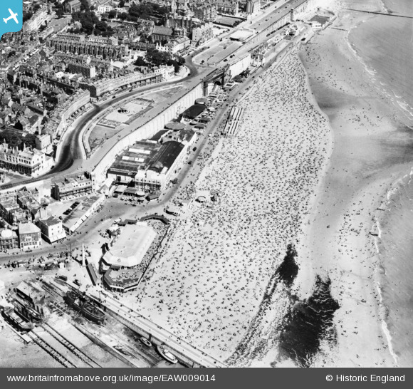
EAW009014 ENGLAND (1947). Crowds on Ramsgate Sands, the Royal Victoria Pavilion and Wellington Crescent, Ramsgate, 1947
© Copyright OpenStreetMap contributors and licensed by the OpenStreetMap Foundation. 2025. Cartography is licensed as CC BY-SA.
Nearby Images (48)
Details
| Title | [EAW009014] Crowds on Ramsgate Sands, the Royal Victoria Pavilion and Wellington Crescent, Ramsgate, 1947 |
| Reference | EAW009014 |
| Date | 12-August-1947 |
| Link | |
| Place name | RAMSGATE |
| Parish | RAMSGATE |
| District | |
| Country | ENGLAND |
| Easting / Northing | 638684, 164843 |
| Longitude / Latitude | 1.4268135001896, 51.331995159872 |
| National Grid Reference | TR387648 |
Pins
 Alan McFaden |
Friday 11th of July 2014 06:26:42 PM | |
 Alan McFaden |
Friday 11th of July 2014 06:26:09 PM | |
 Alan McFaden |
Friday 11th of July 2014 06:25:33 PM | |
 Alan McFaden |
Friday 11th of July 2014 06:24:47 PM |


![[EAW009014] Crowds on Ramsgate Sands, the Royal Victoria Pavilion and Wellington Crescent, Ramsgate, 1947](http://britainfromabove.org.uk/sites/all/libraries/aerofilms-images/public/100x100/EAW/009/EAW009014.jpg)
![[EAW024844] Ramsgate Olympia "Merrie England", Ramsgate, 1949](http://britainfromabove.org.uk/sites/all/libraries/aerofilms-images/public/100x100/EAW/024/EAW024844.jpg)
![[EAW024842] The beach and Marina Esplanade, Ramsgate, 1949](http://britainfromabove.org.uk/sites/all/libraries/aerofilms-images/public/100x100/EAW/024/EAW024842.jpg)
![[EAW009058] Ramsgate Sands, the Ramsgate Olympia and the town, Ramsgate, 1947](http://britainfromabove.org.uk/sites/all/libraries/aerofilms-images/public/100x100/EAW/009/EAW009058.jpg)
![[EAW009056] Ramsgate Sands, the Ramsgate Olympia and the town, Ramsgate, 1947](http://britainfromabove.org.uk/sites/all/libraries/aerofilms-images/public/100x100/EAW/009/EAW009056.jpg)
![[EAW006166] The Olympia, Ramsgate, 1947](http://britainfromabove.org.uk/sites/all/libraries/aerofilms-images/public/100x100/EAW/006/EAW006166.jpg)
![[EPW035453] Wellington Crescent Gardens, the Royal Victoria Pavilion and Ramsgate Sands, Ramsgate, 1931](http://britainfromabove.org.uk/sites/all/libraries/aerofilms-images/public/100x100/EPW/035/EPW035453.jpg)
![[EAW006170] Ramsgate Sands, Wellington Crescent and the town, Ramsgate, from the south-east, 1947](http://britainfromabove.org.uk/sites/all/libraries/aerofilms-images/public/100x100/EAW/006/EAW006170.jpg)
![[EAW006169] Ramsgate Sands, Wellington Crescent and environs, Ramsgate, 1947](http://britainfromabove.org.uk/sites/all/libraries/aerofilms-images/public/100x100/EAW/006/EAW006169.jpg)
![[EPW009173] The Harbour Station and Royal Victoria Pavilion, Ramsgate, 1923](http://britainfromabove.org.uk/sites/all/libraries/aerofilms-images/public/100x100/EPW/009/EPW009173.jpg)
![[EPW000093] Ramsgate Harbour Station, Ramsgate, 1920](http://britainfromabove.org.uk/sites/all/libraries/aerofilms-images/public/100x100/EPW/000/EPW000093.jpg)
![[EAW009015] Crowds on Ramsgate Sands, Wellington Crescent and the town, Ramsgate, 1947](http://britainfromabove.org.uk/sites/all/libraries/aerofilms-images/public/100x100/EAW/009/EAW009015.jpg)
![[EAW006171] Ramsgate Sands, Wellington Crescent and environs, Ramsgate, 1947](http://britainfromabove.org.uk/sites/all/libraries/aerofilms-images/public/100x100/EAW/006/EAW006171.jpg)
![[EPW039325] The Royal Victoria Pavilion and 'Pleasurama', Ramsgate, 1932](http://britainfromabove.org.uk/sites/all/libraries/aerofilms-images/public/100x100/EPW/039/EPW039325.jpg)
![[EPW042859] The Royal Victoria Pavilion, 'Pleasurama' and the town, Ramsgate, from the east, 1933](http://britainfromabove.org.uk/sites/all/libraries/aerofilms-images/public/100x100/EPW/042/EPW042859.jpg)
![[EPW000599] Ramsgate Harbour Station and Wellington Crescent, Ramsgate, 1920](http://britainfromabove.org.uk/sites/all/libraries/aerofilms-images/public/100x100/EPW/000/EPW000599.jpg)
![[EPW000087] Ramsgate Harbour Station, Ramsgate, 1920](http://britainfromabove.org.uk/sites/all/libraries/aerofilms-images/public/100x100/EPW/000/EPW000087.jpg)
![[EPW009174] The Harbour Station and Royal Victoria Pavilion and environs, Ramsgate, 1923](http://britainfromabove.org.uk/sites/all/libraries/aerofilms-images/public/100x100/EPW/009/EPW009174.jpg)
![[EAW006168] Ramsgate Sands, Wellington Crescent and the town, Ramsgate, 1947](http://britainfromabove.org.uk/sites/all/libraries/aerofilms-images/public/100x100/EAW/006/EAW006168.jpg)
![[EAW009052] Crowds on Ramsgate Sands in front of the Ramsgate Olympia, Ramsgate, from the east, 1947](http://britainfromabove.org.uk/sites/all/libraries/aerofilms-images/public/100x100/EAW/009/EAW009052.jpg)
![[EAW009057] Ramsgate Sands, the Marina and the town, Ramsgate, 1947](http://britainfromabove.org.uk/sites/all/libraries/aerofilms-images/public/100x100/EAW/009/EAW009057.jpg)
![[EPW009172] The Harbour Station and Royal Victoria Pavilion, Ramsgate, 1923](http://britainfromabove.org.uk/sites/all/libraries/aerofilms-images/public/100x100/EPW/009/EPW009172.jpg)
![[EAW009054] Crowds on Ramsgate Sands in front of the Ramsgate Olympia, Ramsgate, from the south-east, 1947](http://britainfromabove.org.uk/sites/all/libraries/aerofilms-images/public/100x100/EAW/009/EAW009054.jpg)
![[EAW017591] Ramsgate Sands, Marina Esplanade and the town, Ramsgate, from the south-east, 1948. This image has been produced from a print.](http://britainfromabove.org.uk/sites/all/libraries/aerofilms-images/public/100x100/EAW/017/EAW017591.jpg)
![[EPW009175] The Harbour and environs, Ramsgate, 1923](http://britainfromabove.org.uk/sites/all/libraries/aerofilms-images/public/100x100/EPW/009/EPW009175.jpg)
![[EPW035450] Albion Place Gardens, Wellington Crescent Gardens, Ramsgate Sands and the town, Ramsgate, 1931](http://britainfromabove.org.uk/sites/all/libraries/aerofilms-images/public/100x100/EPW/035/EPW035450.jpg)
![[EAW006167] Ramsgate Sands and the Royal Harbour, Ramsgate, 1947](http://britainfromabove.org.uk/sites/all/libraries/aerofilms-images/public/100x100/EAW/006/EAW006167.jpg)
![[EPW018649] The Royal Harbour and Marina Pier, Ramsgate, 1927](http://britainfromabove.org.uk/sites/all/libraries/aerofilms-images/public/100x100/EPW/018/EPW018649.jpg)
![[EPW048783] Harbour Parade, the seafront and town, Ramsgate, from the south, 1935](http://britainfromabove.org.uk/sites/all/libraries/aerofilms-images/public/100x100/EPW/048/EPW048783.jpg)
![[EAW024843] The Royal Victoria Pavilion and environs, Ramsgate, 1949](http://britainfromabove.org.uk/sites/all/libraries/aerofilms-images/public/100x100/EAW/024/EAW024843.jpg)
![[EAW009051] Crowds at the Royal Victoria Pavilion and Ramsgate Sands, Ramsgate, 1947](http://britainfromabove.org.uk/sites/all/libraries/aerofilms-images/public/100x100/EAW/009/EAW009051.jpg)
![[EPW039324] The Royal Victoria Pavilion, Ramsgate, 1932](http://britainfromabove.org.uk/sites/all/libraries/aerofilms-images/public/100x100/EPW/039/EPW039324.jpg)
![[EAW009049] Ramsgate Sands and the town, Ramsgate, 1947](http://britainfromabove.org.uk/sites/all/libraries/aerofilms-images/public/100x100/EAW/009/EAW009049.jpg)
![[EPW039394] The Merrie England Amusement Park and crowds along Ramsgate Sands, Ramsgate, 1932](http://britainfromabove.org.uk/sites/all/libraries/aerofilms-images/public/100x100/EPW/039/EPW039394.jpg)
![[EAW009005] Crowds on Ramsgate Sands and Royal Harbour, Ramsgate, 1947](http://britainfromabove.org.uk/sites/all/libraries/aerofilms-images/public/100x100/EAW/009/EAW009005.jpg)
![[EAW009053] Crowds on Ramsgate Sands in front of the Ramsgate Olympia, Ramsgate, from the east, 1947](http://britainfromabove.org.uk/sites/all/libraries/aerofilms-images/public/100x100/EAW/009/EAW009053.jpg)
![[EPW042861] The East Pier, Ramsgate Sands, Wellington Crescent and the town, Ramsgate, from the south, 1933](http://britainfromabove.org.uk/sites/all/libraries/aerofilms-images/public/100x100/EPW/042/EPW042861.jpg)
![[EAW017590] Ramsgate Sands, Wellington Crescent Gardens and part of the town, Ramsgate, 1948. This image has been produced from a print.](http://britainfromabove.org.uk/sites/all/libraries/aerofilms-images/public/100x100/EAW/017/EAW017590.jpg)
![[EPW042864] The Royal Harbour and the town, Ramsgate, 1933](http://britainfromabove.org.uk/sites/all/libraries/aerofilms-images/public/100x100/EPW/042/EPW042864.jpg)
![[EAW009055] Ramsgate Sands, the Ramsgate Olympia and the town, Ramsgate, from the south-east, 1947](http://britainfromabove.org.uk/sites/all/libraries/aerofilms-images/public/100x100/EAW/009/EAW009055.jpg)
![[EPW000096] Ramsgate Basin, Ramsgate, 1920](http://britainfromabove.org.uk/sites/all/libraries/aerofilms-images/public/100x100/EPW/000/EPW000096.jpg)
![[EPW039353] Ramsgate Sands, Wellington Crescent and environs, Ramsgate, from the south, 1932](http://britainfromabove.org.uk/sites/all/libraries/aerofilms-images/public/100x100/EPW/039/EPW039353.jpg)
![[EPW000596] The Royal Harbour, Ramsgate, 1920](http://britainfromabove.org.uk/sites/all/libraries/aerofilms-images/public/100x100/EPW/000/EPW000596.jpg)
![[EPW000092] The Clock Tower, Ramsgate Harbour, Ramsgate 1920](http://britainfromabove.org.uk/sites/all/libraries/aerofilms-images/public/100x100/EPW/000/EPW000092.jpg)
![[EPW000702] The Esplanade, Ramsgate, from the southeast, 1920](http://britainfromabove.org.uk/sites/all/libraries/aerofilms-images/public/100x100/EPW/000/EPW000702.jpg)
![[EAW006165] The Basin, Harbour Parade and environs, Ramsgate, 1947](http://britainfromabove.org.uk/sites/all/libraries/aerofilms-images/public/100x100/EAW/006/EAW006165.jpg)
![[EPW035449] The Royal Harbour and environs, Ramsgate, 1931](http://britainfromabove.org.uk/sites/all/libraries/aerofilms-images/public/100x100/EPW/035/EPW035449.jpg)
![[EAW015836] Royal Harbour, Ramsgate, 1948. This image has been produced from a print.](http://britainfromabove.org.uk/sites/all/libraries/aerofilms-images/public/100x100/EAW/015/EAW015836.jpg)


