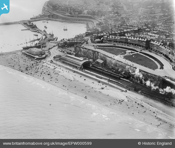
EPW000599 ENGLAND (1920). Ramsgate Harbour Station and Wellington Crescent, Ramsgate, 1920
© Copyright OpenStreetMap contributors and licensed by the OpenStreetMap Foundation. 2025. Cartography is licensed as CC BY-SA.
Nearby Images (48)
Details
| Title | [EPW000599] Ramsgate Harbour Station and Wellington Crescent, Ramsgate, 1920 |
| Reference | EPW000599 |
| Date | April-1920 |
| Link | |
| Place name | RAMSGATE |
| Parish | RAMSGATE |
| District | |
| Country | ENGLAND |
| Easting / Northing | 638684, 164908 |
| Longitude / Latitude | 1.4268570482882, 51.33257864335 |
| National Grid Reference | TR387649 |
Pins
 mattymouse |
Sunday 28th of June 2020 09:34:39 AM | |
 Kentishman |
Monday 10th of August 2015 06:14:03 PM | |
 Kentishman |
Monday 10th of August 2015 05:13:49 PM | |
The disused railway tunnel was used for a narrow gauge (2ft) railway which started in 1936 as the "World Scenic Railway". This line was an electric railway with tram-style overhead pickup. It did not run during the war when the railway tunnel and local caves were used for air-raid shelters. It reopened after WW2 and closed in 1965. |
 John W |
Friday 7th of October 2016 09:54:46 PM |
 Kentishman |
Monday 10th of August 2015 04:47:03 PM | |
 Kentishman |
Monday 10th of August 2015 04:33:17 PM | |
 Kentishman |
Monday 10th of August 2015 04:23:46 PM | |
 Kentishman |
Monday 10th of August 2015 04:12:41 PM | |
 John Wass |
Saturday 9th of August 2014 08:45:40 PM | |
 MB |
Friday 21st of September 2012 06:53:21 PM |


![[EPW000599] Ramsgate Harbour Station and Wellington Crescent, Ramsgate, 1920](http://britainfromabove.org.uk/sites/all/libraries/aerofilms-images/public/100x100/EPW/000/EPW000599.jpg)
![[EAW006168] Ramsgate Sands, Wellington Crescent and the town, Ramsgate, 1947](http://britainfromabove.org.uk/sites/all/libraries/aerofilms-images/public/100x100/EAW/006/EAW006168.jpg)
![[EAW006170] Ramsgate Sands, Wellington Crescent and the town, Ramsgate, from the south-east, 1947](http://britainfromabove.org.uk/sites/all/libraries/aerofilms-images/public/100x100/EAW/006/EAW006170.jpg)
![[EAW006171] Ramsgate Sands, Wellington Crescent and environs, Ramsgate, 1947](http://britainfromabove.org.uk/sites/all/libraries/aerofilms-images/public/100x100/EAW/006/EAW006171.jpg)
![[EAW006166] The Olympia, Ramsgate, 1947](http://britainfromabove.org.uk/sites/all/libraries/aerofilms-images/public/100x100/EAW/006/EAW006166.jpg)
![[EAW009014] Crowds on Ramsgate Sands, the Royal Victoria Pavilion and Wellington Crescent, Ramsgate, 1947](http://britainfromabove.org.uk/sites/all/libraries/aerofilms-images/public/100x100/EAW/009/EAW009014.jpg)
![[EPW035450] Albion Place Gardens, Wellington Crescent Gardens, Ramsgate Sands and the town, Ramsgate, 1931](http://britainfromabove.org.uk/sites/all/libraries/aerofilms-images/public/100x100/EPW/035/EPW035450.jpg)
![[EAW024844] Ramsgate Olympia "Merrie England", Ramsgate, 1949](http://britainfromabove.org.uk/sites/all/libraries/aerofilms-images/public/100x100/EAW/024/EAW024844.jpg)
![[EAW009058] Ramsgate Sands, the Ramsgate Olympia and the town, Ramsgate, 1947](http://britainfromabove.org.uk/sites/all/libraries/aerofilms-images/public/100x100/EAW/009/EAW009058.jpg)
![[EAW009057] Ramsgate Sands, the Marina and the town, Ramsgate, 1947](http://britainfromabove.org.uk/sites/all/libraries/aerofilms-images/public/100x100/EAW/009/EAW009057.jpg)
![[EAW009056] Ramsgate Sands, the Ramsgate Olympia and the town, Ramsgate, 1947](http://britainfromabove.org.uk/sites/all/libraries/aerofilms-images/public/100x100/EAW/009/EAW009056.jpg)
![[EAW009015] Crowds on Ramsgate Sands, Wellington Crescent and the town, Ramsgate, 1947](http://britainfromabove.org.uk/sites/all/libraries/aerofilms-images/public/100x100/EAW/009/EAW009015.jpg)
![[EPW000093] Ramsgate Harbour Station, Ramsgate, 1920](http://britainfromabove.org.uk/sites/all/libraries/aerofilms-images/public/100x100/EPW/000/EPW000093.jpg)
![[EAW006169] Ramsgate Sands, Wellington Crescent and environs, Ramsgate, 1947](http://britainfromabove.org.uk/sites/all/libraries/aerofilms-images/public/100x100/EAW/006/EAW006169.jpg)
![[EAW009052] Crowds on Ramsgate Sands in front of the Ramsgate Olympia, Ramsgate, from the east, 1947](http://britainfromabove.org.uk/sites/all/libraries/aerofilms-images/public/100x100/EAW/009/EAW009052.jpg)
![[EPW035453] Wellington Crescent Gardens, the Royal Victoria Pavilion and Ramsgate Sands, Ramsgate, 1931](http://britainfromabove.org.uk/sites/all/libraries/aerofilms-images/public/100x100/EPW/035/EPW035453.jpg)
![[EAW009005] Crowds on Ramsgate Sands and Royal Harbour, Ramsgate, 1947](http://britainfromabove.org.uk/sites/all/libraries/aerofilms-images/public/100x100/EAW/009/EAW009005.jpg)
![[EAW024842] The beach and Marina Esplanade, Ramsgate, 1949](http://britainfromabove.org.uk/sites/all/libraries/aerofilms-images/public/100x100/EAW/024/EAW024842.jpg)
![[EPW039394] The Merrie England Amusement Park and crowds along Ramsgate Sands, Ramsgate, 1932](http://britainfromabove.org.uk/sites/all/libraries/aerofilms-images/public/100x100/EPW/039/EPW039394.jpg)
![[EAW009049] Ramsgate Sands and the town, Ramsgate, 1947](http://britainfromabove.org.uk/sites/all/libraries/aerofilms-images/public/100x100/EAW/009/EAW009049.jpg)
![[EPW009173] The Harbour Station and Royal Victoria Pavilion, Ramsgate, 1923](http://britainfromabove.org.uk/sites/all/libraries/aerofilms-images/public/100x100/EPW/009/EPW009173.jpg)
![[EPW039325] The Royal Victoria Pavilion and 'Pleasurama', Ramsgate, 1932](http://britainfromabove.org.uk/sites/all/libraries/aerofilms-images/public/100x100/EPW/039/EPW039325.jpg)
![[EPW042859] The Royal Victoria Pavilion, 'Pleasurama' and the town, Ramsgate, from the east, 1933](http://britainfromabove.org.uk/sites/all/libraries/aerofilms-images/public/100x100/EPW/042/EPW042859.jpg)
![[EAW009054] Crowds on Ramsgate Sands in front of the Ramsgate Olympia, Ramsgate, from the south-east, 1947](http://britainfromabove.org.uk/sites/all/libraries/aerofilms-images/public/100x100/EAW/009/EAW009054.jpg)
![[EPW009175] The Harbour and environs, Ramsgate, 1923](http://britainfromabove.org.uk/sites/all/libraries/aerofilms-images/public/100x100/EPW/009/EPW009175.jpg)
![[EPW000087] Ramsgate Harbour Station, Ramsgate, 1920](http://britainfromabove.org.uk/sites/all/libraries/aerofilms-images/public/100x100/EPW/000/EPW000087.jpg)
![[EAW017590] Ramsgate Sands, Wellington Crescent Gardens and part of the town, Ramsgate, 1948. This image has been produced from a print.](http://britainfromabove.org.uk/sites/all/libraries/aerofilms-images/public/100x100/EAW/017/EAW017590.jpg)
![[EAW017591] Ramsgate Sands, Marina Esplanade and the town, Ramsgate, from the south-east, 1948. This image has been produced from a print.](http://britainfromabove.org.uk/sites/all/libraries/aerofilms-images/public/100x100/EAW/017/EAW017591.jpg)
![[EPW009174] The Harbour Station and Royal Victoria Pavilion and environs, Ramsgate, 1923](http://britainfromabove.org.uk/sites/all/libraries/aerofilms-images/public/100x100/EPW/009/EPW009174.jpg)
![[EAW006167] Ramsgate Sands and the Royal Harbour, Ramsgate, 1947](http://britainfromabove.org.uk/sites/all/libraries/aerofilms-images/public/100x100/EAW/006/EAW006167.jpg)
![[EPW009172] The Harbour Station and Royal Victoria Pavilion, Ramsgate, 1923](http://britainfromabove.org.uk/sites/all/libraries/aerofilms-images/public/100x100/EPW/009/EPW009172.jpg)
![[EPW048783] Harbour Parade, the seafront and town, Ramsgate, from the south, 1935](http://britainfromabove.org.uk/sites/all/libraries/aerofilms-images/public/100x100/EPW/048/EPW048783.jpg)
![[EAW009053] Crowds on Ramsgate Sands in front of the Ramsgate Olympia, Ramsgate, from the east, 1947](http://britainfromabove.org.uk/sites/all/libraries/aerofilms-images/public/100x100/EAW/009/EAW009053.jpg)
![[EPW000381] Ramsgate Harbour, Kent, from the north-east, 1920](http://britainfromabove.org.uk/sites/all/libraries/aerofilms-images/public/100x100/EPW/000/EPW000381.jpg)
![[EAW009063] A RAF Avro York flying over Ramsgate Sands, Ramsgate, from the north-west, 1947](http://britainfromabove.org.uk/sites/all/libraries/aerofilms-images/public/100x100/EAW/009/EAW009063.jpg)
![[EPW018649] The Royal Harbour and Marina Pier, Ramsgate, 1927](http://britainfromabove.org.uk/sites/all/libraries/aerofilms-images/public/100x100/EPW/018/EPW018649.jpg)
![[EPW039324] The Royal Victoria Pavilion, Ramsgate, 1932](http://britainfromabove.org.uk/sites/all/libraries/aerofilms-images/public/100x100/EPW/039/EPW039324.jpg)
![[EAW024843] The Royal Victoria Pavilion and environs, Ramsgate, 1949](http://britainfromabove.org.uk/sites/all/libraries/aerofilms-images/public/100x100/EAW/024/EAW024843.jpg)
![[EAW009051] Crowds at the Royal Victoria Pavilion and Ramsgate Sands, Ramsgate, 1947](http://britainfromabove.org.uk/sites/all/libraries/aerofilms-images/public/100x100/EAW/009/EAW009051.jpg)
![[EAW009004] Crowds on Ramsgate Sands, the Royal Victoria Pavilion and the town, Ramsgate, from the south-east, 1947](http://britainfromabove.org.uk/sites/all/libraries/aerofilms-images/public/100x100/EAW/009/EAW009004.jpg)
![[EPW000702] The Esplanade, Ramsgate, from the southeast, 1920](http://britainfromabove.org.uk/sites/all/libraries/aerofilms-images/public/100x100/EPW/000/EPW000702.jpg)
![[EPW042861] The East Pier, Ramsgate Sands, Wellington Crescent and the town, Ramsgate, from the south, 1933](http://britainfromabove.org.uk/sites/all/libraries/aerofilms-images/public/100x100/EPW/042/EPW042861.jpg)
![[EPW000096] Ramsgate Basin, Ramsgate, 1920](http://britainfromabove.org.uk/sites/all/libraries/aerofilms-images/public/100x100/EPW/000/EPW000096.jpg)
![[EPW042864] The Royal Harbour and the town, Ramsgate, 1933](http://britainfromabove.org.uk/sites/all/libraries/aerofilms-images/public/100x100/EPW/042/EPW042864.jpg)
![[EAW009055] Ramsgate Sands, the Ramsgate Olympia and the town, Ramsgate, from the south-east, 1947](http://britainfromabove.org.uk/sites/all/libraries/aerofilms-images/public/100x100/EAW/009/EAW009055.jpg)
![[EPW000092] The Clock Tower, Ramsgate Harbour, Ramsgate 1920](http://britainfromabove.org.uk/sites/all/libraries/aerofilms-images/public/100x100/EPW/000/EPW000092.jpg)
![[EAW006165] The Basin, Harbour Parade and environs, Ramsgate, 1947](http://britainfromabove.org.uk/sites/all/libraries/aerofilms-images/public/100x100/EAW/006/EAW006165.jpg)
![[EAW015836] Royal Harbour, Ramsgate, 1948. This image has been produced from a print.](http://britainfromabove.org.uk/sites/all/libraries/aerofilms-images/public/100x100/EAW/015/EAW015836.jpg)
