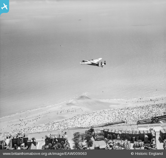
EAW009063 ENGLAND (1947). A RAF Avro York flying over Ramsgate Sands, Ramsgate, from the north-west, 1947
© Copyright OpenStreetMap contributors and licensed by the OpenStreetMap Foundation. 2025. Cartography is licensed as CC BY-SA.
Nearby Images (48)
Details
| Title | [EAW009063] A RAF Avro York flying over Ramsgate Sands, Ramsgate, from the north-west, 1947 |
| Reference | EAW009063 |
| Date | 12-August-1947 |
| Link | |
| Place name | RAMSGATE |
| Parish | RAMSGATE |
| District | |
| Country | ENGLAND |
| Easting / Northing | 638827, 164985 |
| Longitude / Latitude | 1.4289578163451, 51.333209810083 |
| National Grid Reference | TR388650 |
Pins
Be the first to add a comment to this image!


![[EAW009063] A RAF Avro York flying over Ramsgate Sands, Ramsgate, from the north-west, 1947](http://britainfromabove.org.uk/sites/all/libraries/aerofilms-images/public/100x100/EAW/009/EAW009063.jpg)
![[EAW017590] Ramsgate Sands, Wellington Crescent Gardens and part of the town, Ramsgate, 1948. This image has been produced from a print.](http://britainfromabove.org.uk/sites/all/libraries/aerofilms-images/public/100x100/EAW/017/EAW017590.jpg)
![[EAW009003] Crowds on Ramsgate Sands, Ramsgate, 1947](http://britainfromabove.org.uk/sites/all/libraries/aerofilms-images/public/100x100/EAW/009/EAW009003.jpg)
![[EPW039395] The Merrie England Amusement Park and crowds along Ramsgate Sands, Ramsgate, 1932](http://britainfromabove.org.uk/sites/all/libraries/aerofilms-images/public/100x100/EPW/039/EPW039395.jpg)
![[EAW009005] Crowds on Ramsgate Sands and Royal Harbour, Ramsgate, 1947](http://britainfromabove.org.uk/sites/all/libraries/aerofilms-images/public/100x100/EAW/009/EAW009005.jpg)
![[EPW000702] The Esplanade, Ramsgate, from the southeast, 1920](http://britainfromabove.org.uk/sites/all/libraries/aerofilms-images/public/100x100/EPW/000/EPW000702.jpg)
![[EPW039394] The Merrie England Amusement Park and crowds along Ramsgate Sands, Ramsgate, 1932](http://britainfromabove.org.uk/sites/all/libraries/aerofilms-images/public/100x100/EPW/039/EPW039394.jpg)
![[EPW000381] Ramsgate Harbour, Kent, from the north-east, 1920](http://britainfromabove.org.uk/sites/all/libraries/aerofilms-images/public/100x100/EPW/000/EPW000381.jpg)
![[EAW009053] Crowds on Ramsgate Sands in front of the Ramsgate Olympia, Ramsgate, from the east, 1947](http://britainfromabove.org.uk/sites/all/libraries/aerofilms-images/public/100x100/EAW/009/EAW009053.jpg)
![[EAW009016] Ramsgate Sands and the town, Ramsgate, from the south-east, 1947](http://britainfromabove.org.uk/sites/all/libraries/aerofilms-images/public/100x100/EAW/009/EAW009016.jpg)
![[EAW009017] Ramsgate Sands and the town, Ramsgate, from the south-east, 1947](http://britainfromabove.org.uk/sites/all/libraries/aerofilms-images/public/100x100/EAW/009/EAW009017.jpg)
![[EPW035446] Ramsgate Sands, the Royal Harbour and environs, Ramsgate, 1931](http://britainfromabove.org.uk/sites/all/libraries/aerofilms-images/public/100x100/EPW/035/EPW035446.jpg)
![[EAW009052] Crowds on Ramsgate Sands in front of the Ramsgate Olympia, Ramsgate, from the east, 1947](http://britainfromabove.org.uk/sites/all/libraries/aerofilms-images/public/100x100/EAW/009/EAW009052.jpg)
![[EAW006167] Ramsgate Sands and the Royal Harbour, Ramsgate, 1947](http://britainfromabove.org.uk/sites/all/libraries/aerofilms-images/public/100x100/EAW/006/EAW006167.jpg)
![[EAW009015] Crowds on Ramsgate Sands, Wellington Crescent and the town, Ramsgate, 1947](http://britainfromabove.org.uk/sites/all/libraries/aerofilms-images/public/100x100/EAW/009/EAW009015.jpg)
![[EPW000599] Ramsgate Harbour Station and Wellington Crescent, Ramsgate, 1920](http://britainfromabove.org.uk/sites/all/libraries/aerofilms-images/public/100x100/EPW/000/EPW000599.jpg)
![[EAW006168] Ramsgate Sands, Wellington Crescent and the town, Ramsgate, 1947](http://britainfromabove.org.uk/sites/all/libraries/aerofilms-images/public/100x100/EAW/006/EAW006168.jpg)
![[EPW009175] The Harbour and environs, Ramsgate, 1923](http://britainfromabove.org.uk/sites/all/libraries/aerofilms-images/public/100x100/EPW/009/EPW009175.jpg)
![[EAW009004] Crowds on Ramsgate Sands, the Royal Victoria Pavilion and the town, Ramsgate, from the south-east, 1947](http://britainfromabove.org.uk/sites/all/libraries/aerofilms-images/public/100x100/EAW/009/EAW009004.jpg)
![[EAW009054] Crowds on Ramsgate Sands in front of the Ramsgate Olympia, Ramsgate, from the south-east, 1947](http://britainfromabove.org.uk/sites/all/libraries/aerofilms-images/public/100x100/EAW/009/EAW009054.jpg)
![[EAW017591] Ramsgate Sands, Marina Esplanade and the town, Ramsgate, from the south-east, 1948. This image has been produced from a print.](http://britainfromabove.org.uk/sites/all/libraries/aerofilms-images/public/100x100/EAW/017/EAW017591.jpg)
![[EAW006170] Ramsgate Sands, Wellington Crescent and the town, Ramsgate, from the south-east, 1947](http://britainfromabove.org.uk/sites/all/libraries/aerofilms-images/public/100x100/EAW/006/EAW006170.jpg)
![[EAW024844] Ramsgate Olympia "Merrie England", Ramsgate, 1949](http://britainfromabove.org.uk/sites/all/libraries/aerofilms-images/public/100x100/EAW/024/EAW024844.jpg)
![[EAW009014] Crowds on Ramsgate Sands, the Royal Victoria Pavilion and Wellington Crescent, Ramsgate, 1947](http://britainfromabove.org.uk/sites/all/libraries/aerofilms-images/public/100x100/EAW/009/EAW009014.jpg)
![[EAW006171] Ramsgate Sands, Wellington Crescent and environs, Ramsgate, 1947](http://britainfromabove.org.uk/sites/all/libraries/aerofilms-images/public/100x100/EAW/006/EAW006171.jpg)
![[EPW035450] Albion Place Gardens, Wellington Crescent Gardens, Ramsgate Sands and the town, Ramsgate, 1931](http://britainfromabove.org.uk/sites/all/libraries/aerofilms-images/public/100x100/EPW/035/EPW035450.jpg)
![[EPW052886] The Granville Hotel and environs, Ramsgate, 1937. This image has been produced from a copy-negative.](http://britainfromabove.org.uk/sites/all/libraries/aerofilms-images/public/100x100/EPW/052/EPW052886.jpg)
![[EAW024842] The beach and Marina Esplanade, Ramsgate, 1949](http://britainfromabove.org.uk/sites/all/libraries/aerofilms-images/public/100x100/EAW/024/EAW024842.jpg)
![[EPW042859] The Royal Victoria Pavilion, 'Pleasurama' and the town, Ramsgate, from the east, 1933](http://britainfromabove.org.uk/sites/all/libraries/aerofilms-images/public/100x100/EPW/042/EPW042859.jpg)
![[EAW006166] The Olympia, Ramsgate, 1947](http://britainfromabove.org.uk/sites/all/libraries/aerofilms-images/public/100x100/EAW/006/EAW006166.jpg)
![[EAW009058] Ramsgate Sands, the Ramsgate Olympia and the town, Ramsgate, 1947](http://britainfromabove.org.uk/sites/all/libraries/aerofilms-images/public/100x100/EAW/009/EAW009058.jpg)
![[EPW035447] Winterstoke Gardens, Ramsgate Sands, the Royal Harbour and the town, Ramsgate, 1931](http://britainfromabove.org.uk/sites/all/libraries/aerofilms-images/public/100x100/EPW/035/EPW035447.jpg)
![[EAW009056] Ramsgate Sands, the Ramsgate Olympia and the town, Ramsgate, 1947](http://britainfromabove.org.uk/sites/all/libraries/aerofilms-images/public/100x100/EAW/009/EAW009056.jpg)
![[EPW000597] The Granville Hotel, Victoria Gardens, Ramsgate, 1920](http://britainfromabove.org.uk/sites/all/libraries/aerofilms-images/public/100x100/EPW/000/EPW000597.jpg)
![[EAW009057] Ramsgate Sands, the Marina and the town, Ramsgate, 1947](http://britainfromabove.org.uk/sites/all/libraries/aerofilms-images/public/100x100/EAW/009/EAW009057.jpg)
![[EPW009174] The Harbour Station and Royal Victoria Pavilion and environs, Ramsgate, 1923](http://britainfromabove.org.uk/sites/all/libraries/aerofilms-images/public/100x100/EPW/009/EPW009174.jpg)
![[EPW000093] Ramsgate Harbour Station, Ramsgate, 1920](http://britainfromabove.org.uk/sites/all/libraries/aerofilms-images/public/100x100/EPW/000/EPW000093.jpg)
![[EPW035453] Wellington Crescent Gardens, the Royal Victoria Pavilion and Ramsgate Sands, Ramsgate, 1931](http://britainfromabove.org.uk/sites/all/libraries/aerofilms-images/public/100x100/EPW/035/EPW035453.jpg)
![[EAW006169] Ramsgate Sands, Wellington Crescent and environs, Ramsgate, 1947](http://britainfromabove.org.uk/sites/all/libraries/aerofilms-images/public/100x100/EAW/006/EAW006169.jpg)
![[EPW018649] The Royal Harbour and Marina Pier, Ramsgate, 1927](http://britainfromabove.org.uk/sites/all/libraries/aerofilms-images/public/100x100/EPW/018/EPW018649.jpg)
![[EPW009173] The Harbour Station and Royal Victoria Pavilion, Ramsgate, 1923](http://britainfromabove.org.uk/sites/all/libraries/aerofilms-images/public/100x100/EPW/009/EPW009173.jpg)
![[EAW009049] Ramsgate Sands and the town, Ramsgate, 1947](http://britainfromabove.org.uk/sites/all/libraries/aerofilms-images/public/100x100/EAW/009/EAW009049.jpg)
![[EPW039325] The Royal Victoria Pavilion and 'Pleasurama', Ramsgate, 1932](http://britainfromabove.org.uk/sites/all/libraries/aerofilms-images/public/100x100/EPW/039/EPW039325.jpg)
![[EPW009172] The Harbour Station and Royal Victoria Pavilion, Ramsgate, 1923](http://britainfromabove.org.uk/sites/all/libraries/aerofilms-images/public/100x100/EPW/009/EPW009172.jpg)
![[EPW000087] Ramsgate Harbour Station, Ramsgate, 1920](http://britainfromabove.org.uk/sites/all/libraries/aerofilms-images/public/100x100/EPW/000/EPW000087.jpg)
![[EAW024843] The Royal Victoria Pavilion and environs, Ramsgate, 1949](http://britainfromabove.org.uk/sites/all/libraries/aerofilms-images/public/100x100/EAW/024/EAW024843.jpg)
![[EAW009051] Crowds at the Royal Victoria Pavilion and Ramsgate Sands, Ramsgate, 1947](http://britainfromabove.org.uk/sites/all/libraries/aerofilms-images/public/100x100/EAW/009/EAW009051.jpg)
![[EPW039324] The Royal Victoria Pavilion, Ramsgate, 1932](http://britainfromabove.org.uk/sites/all/libraries/aerofilms-images/public/100x100/EPW/039/EPW039324.jpg)