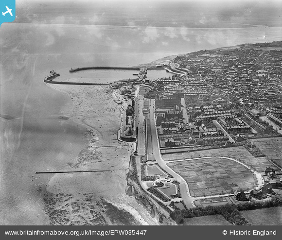
EPW035447 ENGLAND (1931). Winterstoke Gardens, Ramsgate Sands, the Royal Harbour and the town, Ramsgate, 1931
© Copyright OpenStreetMap contributors and licensed by the OpenStreetMap Foundation. 2025. Cartography is licensed as CC BY-SA.
Nearby Images (18)
Details
| Title | [EPW035447] Winterstoke Gardens, Ramsgate Sands, the Royal Harbour and the town, Ramsgate, 1931 |
| Reference | EPW035447 |
| Date | May-1931 |
| Link | |
| Place name | RAMSGATE |
| Parish | RAMSGATE |
| District | |
| Country | ENGLAND |
| Easting / Northing | 638878, 165203 |
| Longitude / Latitude | 1.4298348285225, 51.335145296942 |
| National Grid Reference | TR389652 |
Pins
 Alan McFaden |
Monday 13th of October 2014 10:10:32 AM | |
 Alan McFaden |
Monday 13th of October 2014 10:10:00 AM | |
 Alan McFaden |
Monday 13th of October 2014 10:09:38 AM | |
 Alan McFaden |
Monday 13th of October 2014 10:08:50 AM |


![[EPW035447] Winterstoke Gardens, Ramsgate Sands, the Royal Harbour and the town, Ramsgate, 1931](http://britainfromabove.org.uk/sites/all/libraries/aerofilms-images/public/100x100/EPW/035/EPW035447.jpg)
![[EPW000597] The Granville Hotel, Victoria Gardens, Ramsgate, 1920](http://britainfromabove.org.uk/sites/all/libraries/aerofilms-images/public/100x100/EPW/000/EPW000597.jpg)
![[EPW052886] The Granville Hotel and environs, Ramsgate, 1937. This image has been produced from a copy-negative.](http://britainfromabove.org.uk/sites/all/libraries/aerofilms-images/public/100x100/EPW/052/EPW052886.jpg)
![[EPW000698] The Granville Hotel and Victoria Gardens, Ramsgate, from the north-east, 1920](http://britainfromabove.org.uk/sites/all/libraries/aerofilms-images/public/100x100/EPW/000/EPW000698.jpg)
![[EPW035446] Ramsgate Sands, the Royal Harbour and environs, Ramsgate, 1931](http://britainfromabove.org.uk/sites/all/libraries/aerofilms-images/public/100x100/EPW/035/EPW035446.jpg)
![[EPW000373] The Harbour and Esplanade, Ramsgate, from the north-east, 1920](http://britainfromabove.org.uk/sites/all/libraries/aerofilms-images/public/100x100/EPW/000/EPW000373.jpg)
![[EPW000702] The Esplanade, Ramsgate, from the southeast, 1920](http://britainfromabove.org.uk/sites/all/libraries/aerofilms-images/public/100x100/EPW/000/EPW000702.jpg)
![[EPW039323] Marina Road, the Esplanade and harbour, Ramsgate, from the north-east, 1932](http://britainfromabove.org.uk/sites/all/libraries/aerofilms-images/public/100x100/EPW/039/EPW039323.jpg)
![[EAW009003] Crowds on Ramsgate Sands, Ramsgate, 1947](http://britainfromabove.org.uk/sites/all/libraries/aerofilms-images/public/100x100/EAW/009/EAW009003.jpg)
![[EPW039395] The Merrie England Amusement Park and crowds along Ramsgate Sands, Ramsgate, 1932](http://britainfromabove.org.uk/sites/all/libraries/aerofilms-images/public/100x100/EPW/039/EPW039395.jpg)
![[EPW048781] The Marina Bathing Pool and Victoria Parade, Ramsgate, 1935. This image has been produced from a damaged negative.](http://britainfromabove.org.uk/sites/all/libraries/aerofilms-images/public/100x100/EPW/048/EPW048781.jpg)
![[EAW009012] The Marina Bathing Pool and housing off Victoria Parade, Ramsgate, 1947](http://britainfromabove.org.uk/sites/all/libraries/aerofilms-images/public/100x100/EAW/009/EAW009012.jpg)
![[EAW009011] The Marina Bathing Pool and housing off Victoria Parade, Ramsgate, 1947](http://britainfromabove.org.uk/sites/all/libraries/aerofilms-images/public/100x100/EAW/009/EAW009011.jpg)
![[EAW009063] A RAF Avro York flying over Ramsgate Sands, Ramsgate, from the north-west, 1947](http://britainfromabove.org.uk/sites/all/libraries/aerofilms-images/public/100x100/EAW/009/EAW009063.jpg)
![[EPW048782] The Marina Bathing Pool and Victoria Parade, Ramsgate, 1935. This image has been produced from a damaged negative.](http://britainfromabove.org.uk/sites/all/libraries/aerofilms-images/public/100x100/EPW/048/EPW048782.jpg)
![[EAW009013] The Marina Bathing Pool, Winterstoke Gardens and housing off Victoria Parade, Ramsgate, 1947](http://britainfromabove.org.uk/sites/all/libraries/aerofilms-images/public/100x100/EAW/009/EAW009013.jpg)
![[EAW009002] The Marina Bathing Pool, Ramsgate, 1947](http://britainfromabove.org.uk/sites/all/libraries/aerofilms-images/public/100x100/EAW/009/EAW009002.jpg)
![[EAW017590] Ramsgate Sands, Wellington Crescent Gardens and part of the town, Ramsgate, 1948. This image has been produced from a print.](http://britainfromabove.org.uk/sites/all/libraries/aerofilms-images/public/100x100/EAW/017/EAW017590.jpg)


