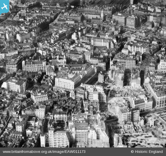
EAW011173 ENGLAND (1947). The Lloyd's Building on Lime Street and cleared sites around Fenchurch Avenue following bomb damage, London, 1947
© Copyright OpenStreetMap contributors and licensed by the OpenStreetMap Foundation. 2025. Cartography is licensed as CC BY-SA.
Nearby Images (20)
Details
| Title | [EAW011173] The Lloyd's Building on Lime Street and cleared sites around Fenchurch Avenue following bomb damage, London, 1947 |
| Reference | EAW011173 |
| Date | 30-September-1947 |
| Link | |
| Place name | LONDON |
| Parish | |
| District | |
| Country | ENGLAND |
| Easting / Northing | 533190, 181086 |
| Longitude / Latitude | -0.080398098189926, 51.512497516668 |
| National Grid Reference | TQ332811 |
Pins
User Comment Contributions
View is looking north. |
 Class31 |
Monday 12th of May 2014 03:56:43 PM |


![[EAW011173] The Lloyd's Building on Lime Street and cleared sites around Fenchurch Avenue following bomb damage, London, 1947](http://britainfromabove.org.uk/sites/all/libraries/aerofilms-images/public/100x100/EAW/011/EAW011173.jpg)
![[EAW035193] The Lloyd's Building and environs, London, 1951. This image has been produced from a print marked by Aerofilms Ltd for photo editing.](http://britainfromabove.org.uk/sites/all/libraries/aerofilms-images/public/100x100/EAW/035/EAW035193.jpg)
![[EAW035190] The Lloyd's Building and environs, London, 1951. This image has been produced from a print marked by Aerofilms Ltd for photo editing.](http://britainfromabove.org.uk/sites/all/libraries/aerofilms-images/public/100x100/EAW/035/EAW035190.jpg)
![[EAW035194] The Lloyd's Building, Lime Street and environs, London, 1951. This image has been produced from a print marked by Aerofilms Ltd for photo editing.](http://britainfromabove.org.uk/sites/all/libraries/aerofilms-images/public/100x100/EAW/035/EAW035194.jpg)
![[EAW035192] The Lloyd's Building and environs, London, 1951. This image has been produced from a print marked by Aerofilms Ltd for photo editing.](http://britainfromabove.org.uk/sites/all/libraries/aerofilms-images/public/100x100/EAW/035/EAW035192.jpg)
![[EAW035191] The Lloyd's Building and environs, London, 1951. This image has been produced from a print marked by Aerofilms Ltd for photo editing.](http://britainfromabove.org.uk/sites/all/libraries/aerofilms-images/public/100x100/EAW/035/EAW035191.jpg)
![[EAW035196] The Lloyd's Building, Fenchurch Street and environs, London, 1951. This image has been produced from a print marked by Aerofilms Ltd for photo editing.](http://britainfromabove.org.uk/sites/all/libraries/aerofilms-images/public/100x100/EAW/035/EAW035196.jpg)
![[EAW004896] Leadenhall Street and environs including bomb damage and cleared ground, London, 1947](http://britainfromabove.org.uk/sites/all/libraries/aerofilms-images/public/100x100/EAW/004/EAW004896.jpg)
![[EAW035195] The Lloyd's Building, Fenchurch Street and environs, London, 1951. This image has been produced from a print marked by Aerofilms Ltd for photo editing.](http://britainfromabove.org.uk/sites/all/libraries/aerofilms-images/public/100x100/EAW/035/EAW035195.jpg)
![[EAW035197] The Lloyd's Building and environs, London, 1951. This image was marked by Aerofilms Ltd for photo editing.](http://britainfromabove.org.uk/sites/all/libraries/aerofilms-images/public/100x100/EAW/035/EAW035197.jpg)
![[EAW035189] Fenchurch Street and the city, London, 1951. This image was marked by Aerofilms Ltd for photo editing.](http://britainfromabove.org.uk/sites/all/libraries/aerofilms-images/public/100x100/EAW/035/EAW035189.jpg)
![[EAW011133] Fenchurch Street and environs, London, 1947. This image has been produced from a print.](http://britainfromabove.org.uk/sites/all/libraries/aerofilms-images/public/100x100/EAW/011/EAW011133.jpg)
![[EAW011134] Leadenhall Street and Bishopsgate by St Helen's Church and environs, London, 1947. This image has been produced from a print.](http://britainfromabove.org.uk/sites/all/libraries/aerofilms-images/public/100x100/EAW/011/EAW011134.jpg)
![[EAW000510] Leadenhall Street and the city, London, from the east, 1946](http://britainfromabove.org.uk/sites/all/libraries/aerofilms-images/public/100x100/EAW/000/EAW000510.jpg)
![[EAW004897] Gracechurch Street and environs, London, 1947](http://britainfromabove.org.uk/sites/all/libraries/aerofilms-images/public/100x100/EAW/004/EAW004897.jpg)
![[EAW011174] Gracechurch Street and environs, London, 1947](http://britainfromabove.org.uk/sites/all/libraries/aerofilms-images/public/100x100/EAW/011/EAW011174.jpg)
![[EAW035188] Fenchurch Street Station and the city, London, 1951](http://britainfromabove.org.uk/sites/all/libraries/aerofilms-images/public/100x100/EAW/035/EAW035188.jpg)
![[EPW057040] The eastern half of the City of London, London, 1938. This image has been produced from a damaged negative.](http://britainfromabove.org.uk/sites/all/libraries/aerofilms-images/public/100x100/EPW/057/EPW057040.jpg)
![[EAW011375] Fenchurch Street and environs, London, 1947](http://britainfromabove.org.uk/sites/all/libraries/aerofilms-images/public/100x100/EAW/011/EAW011375.jpg)
![[EAW011172] The area around Creechurch Lane and Aldgate High Street, London, 1947](http://britainfromabove.org.uk/sites/all/libraries/aerofilms-images/public/100x100/EAW/011/EAW011172.jpg)
