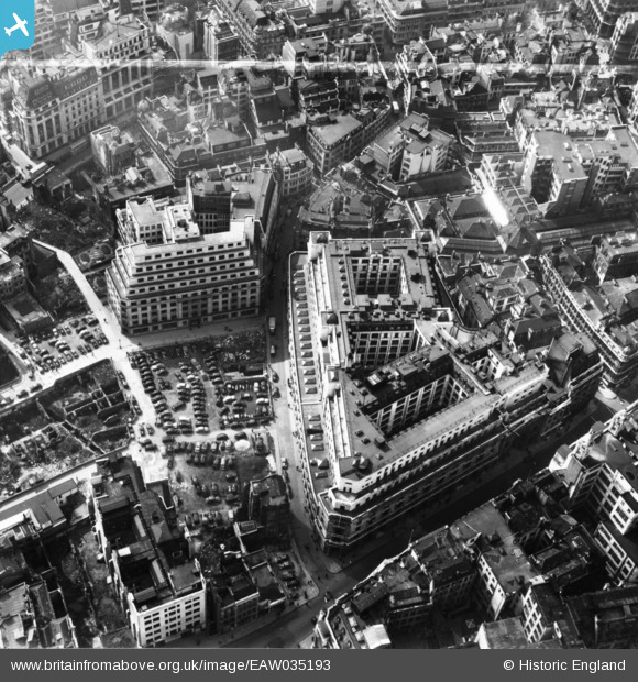
EAW035193 ENGLAND (1951). The Lloyd's Building and environs, London, 1951. This image has been produced from a print marked by Aerofilms Ltd for photo editing.
© Copyright OpenStreetMap contributors and licensed by the OpenStreetMap Foundation. 2025. Cartography is licensed as CC BY-SA.
Nearby Images (25)
Details
| Title | [EAW035193] The Lloyd's Building and environs, London, 1951. This image has been produced from a print marked by Aerofilms Ltd for photo editing. |
| Reference | EAW035193 |
| Date | 3-April-1951 |
| Link | |
| Place name | LONDON |
| Parish | |
| District | |
| Country | ENGLAND |
| Easting / Northing | 533169, 181061 |
| Longitude / Latitude | -0.080710023502715, 51.512277781707 |
| National Grid Reference | TQ332811 |
Pins
Be the first to add a comment to this image!


![[EAW035193] The Lloyd's Building and environs, London, 1951. This image has been produced from a print marked by Aerofilms Ltd for photo editing.](http://britainfromabove.org.uk/sites/all/libraries/aerofilms-images/public/100x100/EAW/035/EAW035193.jpg)
![[EAW035190] The Lloyd's Building and environs, London, 1951. This image has been produced from a print marked by Aerofilms Ltd for photo editing.](http://britainfromabove.org.uk/sites/all/libraries/aerofilms-images/public/100x100/EAW/035/EAW035190.jpg)
![[EAW035196] The Lloyd's Building, Fenchurch Street and environs, London, 1951. This image has been produced from a print marked by Aerofilms Ltd for photo editing.](http://britainfromabove.org.uk/sites/all/libraries/aerofilms-images/public/100x100/EAW/035/EAW035196.jpg)
![[EAW035194] The Lloyd's Building, Lime Street and environs, London, 1951. This image has been produced from a print marked by Aerofilms Ltd for photo editing.](http://britainfromabove.org.uk/sites/all/libraries/aerofilms-images/public/100x100/EAW/035/EAW035194.jpg)
![[EAW011173] The Lloyd's Building on Lime Street and cleared sites around Fenchurch Avenue following bomb damage, London, 1947](http://britainfromabove.org.uk/sites/all/libraries/aerofilms-images/public/100x100/EAW/011/EAW011173.jpg)
![[EAW035192] The Lloyd's Building and environs, London, 1951. This image has been produced from a print marked by Aerofilms Ltd for photo editing.](http://britainfromabove.org.uk/sites/all/libraries/aerofilms-images/public/100x100/EAW/035/EAW035192.jpg)
![[EAW035195] The Lloyd's Building, Fenchurch Street and environs, London, 1951. This image has been produced from a print marked by Aerofilms Ltd for photo editing.](http://britainfromabove.org.uk/sites/all/libraries/aerofilms-images/public/100x100/EAW/035/EAW035195.jpg)
![[EAW035197] The Lloyd's Building and environs, London, 1951. This image was marked by Aerofilms Ltd for photo editing.](http://britainfromabove.org.uk/sites/all/libraries/aerofilms-images/public/100x100/EAW/035/EAW035197.jpg)
![[EAW035191] The Lloyd's Building and environs, London, 1951. This image has been produced from a print marked by Aerofilms Ltd for photo editing.](http://britainfromabove.org.uk/sites/all/libraries/aerofilms-images/public/100x100/EAW/035/EAW035191.jpg)
![[EAW035189] Fenchurch Street and the city, London, 1951. This image was marked by Aerofilms Ltd for photo editing.](http://britainfromabove.org.uk/sites/all/libraries/aerofilms-images/public/100x100/EAW/035/EAW035189.jpg)
![[EAW004896] Leadenhall Street and environs including bomb damage and cleared ground, London, 1947](http://britainfromabove.org.uk/sites/all/libraries/aerofilms-images/public/100x100/EAW/004/EAW004896.jpg)
![[EAW011133] Fenchurch Street and environs, London, 1947. This image has been produced from a print.](http://britainfromabove.org.uk/sites/all/libraries/aerofilms-images/public/100x100/EAW/011/EAW011133.jpg)
![[EAW000510] Leadenhall Street and the city, London, from the east, 1946](http://britainfromabove.org.uk/sites/all/libraries/aerofilms-images/public/100x100/EAW/000/EAW000510.jpg)
![[EAW004897] Gracechurch Street and environs, London, 1947](http://britainfromabove.org.uk/sites/all/libraries/aerofilms-images/public/100x100/EAW/004/EAW004897.jpg)
![[EAW011174] Gracechurch Street and environs, London, 1947](http://britainfromabove.org.uk/sites/all/libraries/aerofilms-images/public/100x100/EAW/011/EAW011174.jpg)
![[EAW035188] Fenchurch Street Station and the city, London, 1951](http://britainfromabove.org.uk/sites/all/libraries/aerofilms-images/public/100x100/EAW/035/EAW035188.jpg)
![[EAW011134] Leadenhall Street and Bishopsgate by St Helen's Church and environs, London, 1947. This image has been produced from a print.](http://britainfromabove.org.uk/sites/all/libraries/aerofilms-images/public/100x100/EAW/011/EAW011134.jpg)
![[EPW057040] The eastern half of the City of London, London, 1938. This image has been produced from a damaged negative.](http://britainfromabove.org.uk/sites/all/libraries/aerofilms-images/public/100x100/EPW/057/EPW057040.jpg)
![[EAW011132] Cleared area following bomb damage between Great Tower Street and Fenchurch Street Railway Station, London, 1947. This image has been produced from a print.](http://britainfromabove.org.uk/sites/all/libraries/aerofilms-images/public/100x100/EAW/011/EAW011132.jpg)
![[EAW000631] Custom House and the surrounding area, London, 1946](http://britainfromabove.org.uk/sites/all/libraries/aerofilms-images/public/100x100/EAW/000/EAW000631.jpg)
![[EAW011375] Fenchurch Street and environs, London, 1947](http://britainfromabove.org.uk/sites/all/libraries/aerofilms-images/public/100x100/EAW/011/EAW011375.jpg)
![[EAW016644] Bank Junction and environs, London Bridge Station and the River Thames, London, from the north-west, 1948](http://britainfromabove.org.uk/sites/all/libraries/aerofilms-images/public/100x100/EAW/016/EAW016644.jpg)
![[EAW011172] The area around Creechurch Lane and Aldgate High Street, London, 1947](http://britainfromabove.org.uk/sites/all/libraries/aerofilms-images/public/100x100/EAW/011/EAW011172.jpg)
![[EAW013047] The area around Monument, Gracechurch Street and King William Street, London, 1946](http://britainfromabove.org.uk/sites/all/libraries/aerofilms-images/public/100x100/EAW/013/EAW013047.jpg)
![[EPW005764] Monument, Monument Street and environs, London, 1921. This image has been produced from a copy-negative.](http://britainfromabove.org.uk/sites/all/libraries/aerofilms-images/public/100x100/EPW/005/EPW005764.jpg)