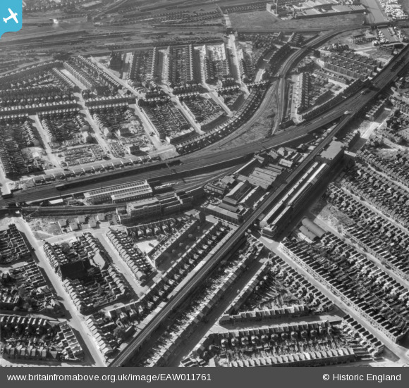
EAW011761 ENGLAND (1947). J. Stone and Company Limited Engineering Work, Deptford, 1947
© Copyright OpenStreetMap contributors and licensed by the OpenStreetMap Foundation. 2025. Cartography is licensed as CC BY-SA.
Nearby Images (8)
Details
| Title | [EAW011761] J. Stone and Company Limited Engineering Work, Deptford, 1947 |
| Reference | EAW011761 |
| Date | 9-October-1947 |
| Link | |
| Place name | DEPTFORD |
| Parish | |
| District | |
| Country | ENGLAND |
| Easting / Northing | 536517, 177658 |
| Longitude / Latitude | -0.033804192195693, 51.480895139136 |
| National Grid Reference | TQ365777 |
Pins
 ladyceecee |
Thursday 29th of April 2021 03:35:50 PM | |
 Mark B |
Monday 16th of April 2018 10:07:30 PM | |
 Mark B |
Monday 16th of April 2018 10:06:29 PM | |
 Mark B |
Monday 16th of April 2018 10:05:07 PM | |
 deptfordscouter |
Thursday 5th of June 2014 11:01:33 AM | |
 stimarco |
Wednesday 22nd of August 2012 12:35:53 PM |
User Comment Contributions
An all Maunsell train - A Mogul with a seven set (or a three and four set) and a utility van on the rear. A new roof going on the LT sheds and both prefabs and new housing being built in the bombed areas. I believe this area of London had as much bombing as any.... often suffering the tale end of payloads dropped from flights making their way home from the city. |
 Maurice |
Friday 17th of January 2014 12:13:20 PM |
I would be interested Maurice, how you could have identified the "Maunsell" train and that the loco was an "N" or "N1" class mogul. You must have extremely good eyesight, from "our" distance, or perhaps I'm missing something! |
 Wilmington |
Friday 17th of January 2014 12:13:20 PM |


![[EAW011761] J. Stone and Company Limited Engineering Work, Deptford, 1947](http://britainfromabove.org.uk/sites/all/libraries/aerofilms-images/public/100x100/EAW/011/EAW011761.jpg)
![[EAW011767] J. Stone and Company Limited Engineering Works, Deptford, 1947](http://britainfromabove.org.uk/sites/all/libraries/aerofilms-images/public/100x100/EAW/011/EAW011767.jpg)
![[EAW011765] J. Stone and Company Limited Engineering Works, Deptford, 1947](http://britainfromabove.org.uk/sites/all/libraries/aerofilms-images/public/100x100/EAW/011/EAW011765.jpg)
![[EAW011762] J. Stone and Company Limited Engineering Works, Deptford, 1947](http://britainfromabove.org.uk/sites/all/libraries/aerofilms-images/public/100x100/EAW/011/EAW011762.jpg)
![[EAW011763] J. Stone and Company Limited Engineering Works and environs, Deptford, 1947](http://britainfromabove.org.uk/sites/all/libraries/aerofilms-images/public/100x100/EAW/011/EAW011763.jpg)
![[EAW011764] J. Stone and Company Limited Engineering Works and environs, Deptford, 1947](http://britainfromabove.org.uk/sites/all/libraries/aerofilms-images/public/100x100/EAW/011/EAW011764.jpg)
![[EAW011760] J. Stone and Company Limited Engineering Works and environs, Deptford, 1947](http://britainfromabove.org.uk/sites/all/libraries/aerofilms-images/public/100x100/EAW/011/EAW011760.jpg)
![[EAW011766] J. Stone and Company Limited Engineering Works and environs, Deptford, 1947](http://britainfromabove.org.uk/sites/all/libraries/aerofilms-images/public/100x100/EAW/011/EAW011766.jpg)
