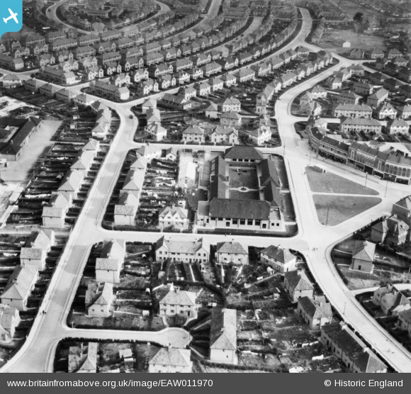
EAW011970 ENGLAND (1947). The Filwood Social Centre and surrounding streets, Filwood Park, 1947
© Copyright OpenStreetMap contributors and licensed by the OpenStreetMap Foundation. 2025. Cartography is licensed as CC BY-SA.
Nearby Images (9)
EAW011970

EAW011973

EAW011968

EAW011967

EAW011971

EAW011974

EAW011966

EAW011972

EAW011969

Details
| Title | [EAW011970] The Filwood Social Centre and surrounding streets, Filwood Park, 1947 |
| Reference | EAW011970 |
| Date | 1-November-1947 |
| Link | |
| Place name | FILWOOD PARK |
| Parish | |
| District | |
| Country | ENGLAND |
| Easting / Northing | 359362, 169816 |
| Longitude / Latitude | -2.5845590967879, 51.425401417706 |
| National Grid Reference | ST594698 |
Pins
 Class31 |
Thursday 27th of February 2014 12:36:48 PM | |
Class31 |
Thursday 27th of February 2014 12:32:48 PM | |
Class31 |
Thursday 27th of February 2014 12:32:01 PM | |
Class31 |
Thursday 27th of February 2014 12:31:31 PM | |
Class31 |
Thursday 27th of February 2014 12:30:35 PM | |
Class31 |
Thursday 27th of February 2014 12:30:13 PM | |
Class31 |
Thursday 27th of February 2014 12:29:34 PM | |
Class31 |
Thursday 27th of February 2014 12:29:12 PM | |
Class31 |
Thursday 27th of February 2014 12:28:50 PM | |
Class31 |
Thursday 27th of February 2014 12:27:57 PM | |
Class31 |
Thursday 27th of February 2014 12:27:29 PM | |
Class31 |
Thursday 27th of February 2014 12:26:23 PM | |
Class31 |
Thursday 27th of February 2014 09:59:13 AM | |
Class31 |
Thursday 27th of February 2014 09:58:50 AM |