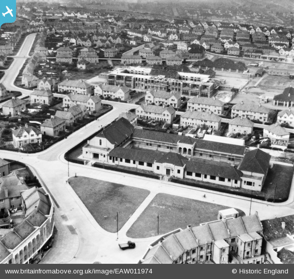
EAW011974 ENGLAND (1947). The Filwood Social Centre and environs, Filwood Park, from the south-east, 1947
© Copyright OpenStreetMap contributors and licensed by the OpenStreetMap Foundation. 2025. Cartography is licensed as CC BY-SA.
Nearby Images (9)
Details
| Title | [EAW011974] The Filwood Social Centre and environs, Filwood Park, from the south-east, 1947 |
| Reference | EAW011974 |
| Date | 1-November-1947 |
| Link | |
| Place name | FILWOOD PARK |
| Parish | |
| District | |
| Country | ENGLAND |
| Easting / Northing | 359360, 169772 |
| Longitude / Latitude | -2.5845828158426, 51.425005619497 |
| National Grid Reference | ST594698 |
Pins
 Class31 |
Thursday 27th of February 2014 09:47:31 AM | |
 Class31 |
Thursday 27th of February 2014 09:47:03 AM | |
 Class31 |
Thursday 27th of February 2014 09:46:40 AM | |
 Class31 |
Thursday 27th of February 2014 09:46:09 AM | |
 Class31 |
Thursday 27th of February 2014 12:13:59 AM | |
 Class31 |
Thursday 27th of February 2014 12:11:47 AM | |
 Class31 |
Thursday 27th of February 2014 12:11:27 AM | |
 Class31 |
Thursday 27th of February 2014 12:10:56 AM | |
 Class31 |
Thursday 27th of February 2014 12:10:36 AM |
User Comment Contributions
Melvin Square 20/2/2014 |
 Class31 |
Thursday 27th of February 2014 09:50:11 AM |


![[EAW011974] The Filwood Social Centre and environs, Filwood Park, from the south-east, 1947](http://britainfromabove.org.uk/sites/all/libraries/aerofilms-images/public/100x100/EAW/011/EAW011974.jpg)
![[EAW011971] The Filwood Social Centre, Filwood Park, 1947](http://britainfromabove.org.uk/sites/all/libraries/aerofilms-images/public/100x100/EAW/011/EAW011971.jpg)
![[EAW011968] The Filwood Social Centre and surrounding streets, Filwood Park, 1947](http://britainfromabove.org.uk/sites/all/libraries/aerofilms-images/public/100x100/EAW/011/EAW011968.jpg)
![[EAW011966] The Filwood Social Centre and surrounding streets, Filwood Park, 1947](http://britainfromabove.org.uk/sites/all/libraries/aerofilms-images/public/100x100/EAW/011/EAW011966.jpg)
![[EAW011967] The Filwood Social Centre and surrounding streets, Filwood Park, 1947](http://britainfromabove.org.uk/sites/all/libraries/aerofilms-images/public/100x100/EAW/011/EAW011967.jpg)
![[EAW011969] The Filwood Social Centre and Filwood Broadway, Filwood Park, 1947](http://britainfromabove.org.uk/sites/all/libraries/aerofilms-images/public/100x100/EAW/011/EAW011969.jpg)
![[EAW011970] The Filwood Social Centre and surrounding streets, Filwood Park, 1947](http://britainfromabove.org.uk/sites/all/libraries/aerofilms-images/public/100x100/EAW/011/EAW011970.jpg)
![[EAW011972] The Filwood Social Centre and environs, Filwood Park, from the south-east, 1947](http://britainfromabove.org.uk/sites/all/libraries/aerofilms-images/public/100x100/EAW/011/EAW011972.jpg)
![[EAW011973] Connaught Road, the Filwood Social Centre and Filwood Broadway, Filwood Park, 1947](http://britainfromabove.org.uk/sites/all/libraries/aerofilms-images/public/100x100/EAW/011/EAW011973.jpg)