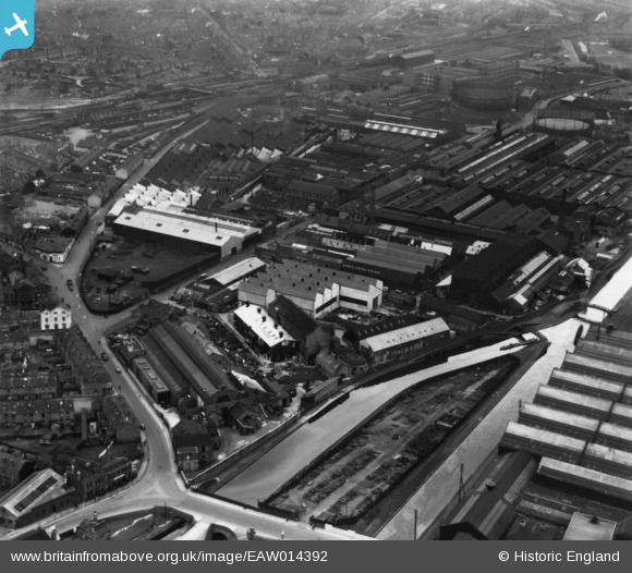
EAW014392 ENGLAND (1948). The Incandescent Heat Company Works on Cornwall Road and adjacent factories, Smethwick, 1948. This image has been produced from a print.
© Copyright OpenStreetMap contributors and licensed by the OpenStreetMap Foundation. 2025. Cartography is licensed as CC BY-SA.
Nearby Images (31)
Details
| Title | [EAW014392] The Incandescent Heat Company Works on Cornwall Road and adjacent factories, Smethwick, 1948. This image has been produced from a print. |
| Reference | EAW014392 |
| Date | 13-April-1948 |
| Link | |
| Place name | SMETHWICK |
| Parish | |
| District | |
| Country | ENGLAND |
| Easting / Northing | 402906, 289123 |
| Longitude / Latitude | -1.95718732771, 52.499635488022 |
| National Grid Reference | SP029891 |
Pins
 Matt Aldred edob.mattaldred.com |
Friday 14th of May 2021 05:42:20 PM | |
 Matt Aldred edob.mattaldred.com |
Friday 14th of May 2021 05:41:53 PM | |
 Class31 |
Friday 28th of August 2015 08:34:50 AM | |
 Class31 |
Friday 28th of August 2015 08:33:53 AM |


![[EAW014392] The Incandescent Heat Company Works on Cornwall Road and adjacent factories, Smethwick, 1948. This image has been produced from a print.](http://britainfromabove.org.uk/sites/all/libraries/aerofilms-images/public/100x100/EAW/014/EAW014392.jpg)
![[EAW014395] The Incandescent Heat Company Works on Cornwall Road, Smethwick, 1948. This image has been produced from a print.](http://britainfromabove.org.uk/sites/all/libraries/aerofilms-images/public/100x100/EAW/014/EAW014395.jpg)
![[EAW001562] The Incandescent Heat Co Works and the Kingston Metal Works alongside the Birmingham Canal, Smethwick, 1946](http://britainfromabove.org.uk/sites/all/libraries/aerofilms-images/public/100x100/EAW/001/EAW001562.jpg)
![[EAW014397] The Incandescent Heat Company Works on Cornwall Road and environs, Smethwick, 1948. This image has been produced from a print.](http://britainfromabove.org.uk/sites/all/libraries/aerofilms-images/public/100x100/EAW/014/EAW014397.jpg)
![[EAW001560] The Incandescent Heat Co Works and the Phillips Cycle Works off Cornwall Road, Smethwick, 1946](http://britainfromabove.org.uk/sites/all/libraries/aerofilms-images/public/100x100/EAW/001/EAW001560.jpg)
![[EAW014396] The Incandescent Heat Company Works on Cornwall Road and adjacent factories, Smethwick, 1948. This image has been produced from a print.](http://britainfromabove.org.uk/sites/all/libraries/aerofilms-images/public/100x100/EAW/014/EAW014396.jpg)
![[EAW014398] The Incandescent Heat Company Works on Cornwall Road, Smethwick, 1948. This image has been produced from a print.](http://britainfromabove.org.uk/sites/all/libraries/aerofilms-images/public/100x100/EAW/014/EAW014398.jpg)
![[EAW014391] The Incandescent Heat Company Works on Cornwall Road and adjacent factories, Smethwick, 1948. This image has been produced from a print marked by Aerofilms Ltd for photo editing.](http://britainfromabove.org.uk/sites/all/libraries/aerofilms-images/public/100x100/EAW/014/EAW014391.jpg)
![[EPW057433] The Incandescent Heat Company Works at British Mills on Cornwall Road and adjacent factories, Smethwick, 1938](http://britainfromabove.org.uk/sites/all/libraries/aerofilms-images/public/100x100/EPW/057/EPW057433.jpg)
![[EAW001559] The Incandescent Heat Co Works off Cornwall Road, Smethwick, 1946](http://britainfromabove.org.uk/sites/all/libraries/aerofilms-images/public/100x100/EAW/001/EAW001559.jpg)
![[EPW057435] The Incandescent Heat Company Works at British Mills on Cornwall Road and adjacent factories, Smethwick, 1938](http://britainfromabove.org.uk/sites/all/libraries/aerofilms-images/public/100x100/EPW/057/EPW057435.jpg)
![[EAW001561] The Incandescent Heat Co Works and the Phillips Cycle Works off Cornwall Road, Smethwick, 1946](http://britainfromabove.org.uk/sites/all/libraries/aerofilms-images/public/100x100/EAW/001/EAW001561.jpg)
![[EPW057439] The Incandescent Heat Company Works at British Mills on Cornwall Road and adjacent factories, Smethwick, 1938](http://britainfromabove.org.uk/sites/all/libraries/aerofilms-images/public/100x100/EPW/057/EPW057439.jpg)
![[EAW014394] The Incandescent Heat Company Works on Cornwall Road and adjacent factories, Smethwick, 1948. This image has been produced from a print.](http://britainfromabove.org.uk/sites/all/libraries/aerofilms-images/public/100x100/EAW/014/EAW014394.jpg)
![[EPW057438] The Incandescent Heat Company Works at British Mills on Cornwall Road and adjacent factories, Smethwick, 1938](http://britainfromabove.org.uk/sites/all/libraries/aerofilms-images/public/100x100/EPW/057/EPW057438.jpg)
![[EAW014393] The Incandescent Heat Company Works on Cornwall Road and adjacent factories, Smethwick, 1948. This image has been produced from a print.](http://britainfromabove.org.uk/sites/all/libraries/aerofilms-images/public/100x100/EAW/014/EAW014393.jpg)
![[EPW057434] The Incandescent Heat Company Works at British Mills on Cornwall Road and adjacent factories, Smethwick, 1938](http://britainfromabove.org.uk/sites/all/libraries/aerofilms-images/public/100x100/EPW/057/EPW057434.jpg)
![[EAW001558] The Incandescent Heat Co Works and the Kingston Metal Works, Smethwick, 1946](http://britainfromabove.org.uk/sites/all/libraries/aerofilms-images/public/100x100/EAW/001/EAW001558.jpg)
![[EAW014399] The Incandescent Heat Company Works on Cornwall Road and environs, Smethwick, from the south-west, 1948. This image has been produced from a print.](http://britainfromabove.org.uk/sites/all/libraries/aerofilms-images/public/100x100/EAW/014/EAW014399.jpg)
![[EAW001563] The Incandescent Heat Co Works, the Birmingham Canal and the surrounding industrial area, Smethwick, 1946](http://britainfromabove.org.uk/sites/all/libraries/aerofilms-images/public/100x100/EAW/001/EAW001563.jpg)
![[EPW057436] The Incandescent Heat Company Works at British Mills on Cornwall Road and adjacent factories, Smethwick, 1938](http://britainfromabove.org.uk/sites/all/libraries/aerofilms-images/public/100x100/EPW/057/EPW057436.jpg)
![[EAW014390] The Incandescent Heat Company Works on Cornwall Road and adjacent factories, Smethwick, 1948. This image has been produced from a print.](http://britainfromabove.org.uk/sites/all/libraries/aerofilms-images/public/100x100/EAW/014/EAW014390.jpg)
![[EPW053093] Factories along the Birmingham Canal from Rolfe Bridge to Soho Railway Bridge, Soho, 1937](http://britainfromabove.org.uk/sites/all/libraries/aerofilms-images/public/100x100/EPW/053/EPW053093.jpg)
![[EPW057437] The Incandescent Heat Company Works at British Mills on Cornwall Road and adjacent factories, Smethwick, 1938](http://britainfromabove.org.uk/sites/all/libraries/aerofilms-images/public/100x100/EPW/057/EPW057437.jpg)
![[EPW044406] The Kingston Metal Works and adjacent industrial works, Smethwick, 1934](http://britainfromabove.org.uk/sites/all/libraries/aerofilms-images/public/100x100/EPW/044/EPW044406.jpg)
![[EAW001556] The Incandescent Heat Co Works and the Phillips Cycle Works, Smethwick, 1946](http://britainfromabove.org.uk/sites/all/libraries/aerofilms-images/public/100x100/EAW/001/EAW001556.jpg)
![[EAW001557] The Incandescent Heat Co Works, the Phillips Cycle Works and the surrounding residential area, Smethwick, 1946](http://britainfromabove.org.uk/sites/all/libraries/aerofilms-images/public/100x100/EAW/001/EAW001557.jpg)
![[EPW044407] The Kingston Metal Works and adjacent industrial works, Smethwick, from the west, 1934](http://britainfromabove.org.uk/sites/all/libraries/aerofilms-images/public/100x100/EPW/044/EPW044407.jpg)
![[EPW044408] The Kingston Metal Works and adjacent industrial works, Smethwick, from the north-west, 1934](http://britainfromabove.org.uk/sites/all/libraries/aerofilms-images/public/100x100/EPW/044/EPW044408.jpg)
![[EPW044411] The Kingston Metal Works and adjacent industrial works, Smethwick, from the west, 1934](http://britainfromabove.org.uk/sites/all/libraries/aerofilms-images/public/100x100/EPW/044/EPW044411.jpg)
![[EPW044409] The Kingston Metal Works and adjacent industrial works, Smethwick, from the south-west, 1934](http://britainfromabove.org.uk/sites/all/libraries/aerofilms-images/public/100x100/EPW/044/EPW044409.jpg)