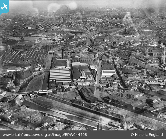
EPW044408 ENGLAND (1934). The Kingston Metal Works and adjacent industrial works, Smethwick, from the north-west, 1934
© Copyright OpenStreetMap contributors and licensed by the OpenStreetMap Foundation. 2025. Cartography is licensed as CC BY-SA.
Nearby Images (33)
Details
| Title | [EPW044408] The Kingston Metal Works and adjacent industrial works, Smethwick, from the north-west, 1934 |
| Reference | EPW044408 |
| Date | May-1934 |
| Link | |
| Place name | SMETHWICK |
| Parish | |
| District | |
| Country | ENGLAND |
| Easting / Northing | 402701, 288940 |
| Longitude / Latitude | -1.960208976736, 52.497991193359 |
| National Grid Reference | SP027889 |
Pins
 Class31 |
Thursday 27th of August 2015 08:35:16 PM | |
 Class31 |
Thursday 27th of August 2015 08:34:42 PM | |
 Class31 |
Thursday 27th of August 2015 08:34:06 PM | |
 Martin |
Tuesday 27th of August 2013 05:44:59 PM | |
 Martin |
Tuesday 27th of August 2013 05:44:29 PM |
User Comment Contributions
Birmingham Canal from Rolfe Bridge, Bridge Street North, Smethwick, 12/08/2015 |
 Class31 |
Thursday 27th of August 2015 08:35:44 PM |


![[EPW044408] The Kingston Metal Works and adjacent industrial works, Smethwick, from the north-west, 1934](http://britainfromabove.org.uk/sites/all/libraries/aerofilms-images/public/100x100/EPW/044/EPW044408.jpg)
![[EPW044411] The Kingston Metal Works and adjacent industrial works, Smethwick, from the west, 1934](http://britainfromabove.org.uk/sites/all/libraries/aerofilms-images/public/100x100/EPW/044/EPW044411.jpg)
![[EPW044407] The Kingston Metal Works and adjacent industrial works, Smethwick, from the west, 1934](http://britainfromabove.org.uk/sites/all/libraries/aerofilms-images/public/100x100/EPW/044/EPW044407.jpg)
![[EPW044409] The Kingston Metal Works and adjacent industrial works, Smethwick, from the south-west, 1934](http://britainfromabove.org.uk/sites/all/libraries/aerofilms-images/public/100x100/EPW/044/EPW044409.jpg)
![[EPW044410] The Kingston Metal Works and adjacent industrial works, Smethwick, from the north-west, 1934](http://britainfromabove.org.uk/sites/all/libraries/aerofilms-images/public/100x100/EPW/044/EPW044410.jpg)
![[EAW017731] The Evered & Co Ltd Surrey Works, Smethwick, from the south-east, 1948. This image has been produced from a print.](http://britainfromabove.org.uk/sites/all/libraries/aerofilms-images/public/100x100/EAW/017/EAW017731.jpg)
![[EPW053085] Kingston Metal Works and Credenda Cycle Acessories Works, Smethwick, 1937. This image has been produced from a copy-negative.](http://britainfromabove.org.uk/sites/all/libraries/aerofilms-images/public/100x100/EPW/053/EPW053085.jpg)
![[EPW053084] Kingston Metal Works and Credenda Cycle Acessories Works, Smethwick, 1937. This image has been produced from a copy-negative.](http://britainfromabove.org.uk/sites/all/libraries/aerofilms-images/public/100x100/EPW/053/EPW053084.jpg)
![[EAW017734] The Evered & Co Ltd Surrey Works, Smethwick, from the south-east, 1948. This image has been produced from a print.](http://britainfromabove.org.uk/sites/all/libraries/aerofilms-images/public/100x100/EAW/017/EAW017734.jpg)
![[EAW001563] The Incandescent Heat Co Works, the Birmingham Canal and the surrounding industrial area, Smethwick, 1946](http://britainfromabove.org.uk/sites/all/libraries/aerofilms-images/public/100x100/EAW/001/EAW001563.jpg)
![[EAW014399] The Incandescent Heat Company Works on Cornwall Road and environs, Smethwick, from the south-west, 1948. This image has been produced from a print.](http://britainfromabove.org.uk/sites/all/libraries/aerofilms-images/public/100x100/EAW/014/EAW014399.jpg)
![[EAW014394] The Incandescent Heat Company Works on Cornwall Road and adjacent factories, Smethwick, 1948. This image has been produced from a print.](http://britainfromabove.org.uk/sites/all/libraries/aerofilms-images/public/100x100/EAW/014/EAW014394.jpg)
![[EPW044406] The Kingston Metal Works and adjacent industrial works, Smethwick, 1934](http://britainfromabove.org.uk/sites/all/libraries/aerofilms-images/public/100x100/EPW/044/EPW044406.jpg)
![[EAW001203] A cityscape over the industrial and residential area of Soho and Sandwell, Smethwick, 1946](http://britainfromabove.org.uk/sites/all/libraries/aerofilms-images/public/100x100/EAW/001/EAW001203.jpg)
![[EAW014391] The Incandescent Heat Company Works on Cornwall Road and adjacent factories, Smethwick, 1948. This image has been produced from a print marked by Aerofilms Ltd for photo editing.](http://britainfromabove.org.uk/sites/all/libraries/aerofilms-images/public/100x100/EAW/014/EAW014391.jpg)
![[EAW017735] The Evered & Co Ltd Surrey Works, Smethwick, 1948. This image was modified by the Aerofilms Ltd Artists' Department and has been produced from a copy-negative.](http://britainfromabove.org.uk/sites/all/libraries/aerofilms-images/public/100x100/EAW/017/EAW017735.jpg)
![[EAW017736] The Evered & Co Ltd Surrey Works, Smethwick, 1948. This image has been produced from a print.](http://britainfromabove.org.uk/sites/all/libraries/aerofilms-images/public/100x100/EAW/017/EAW017736.jpg)
![[EAW017730] The Evered & Co Ltd Surrey Works, Smethwick, 1948. This image has been produced from a print marked by Aerofilms Ltd for photo editing.](http://britainfromabove.org.uk/sites/all/libraries/aerofilms-images/public/100x100/EAW/017/EAW017730.jpg)
![[EAW014396] The Incandescent Heat Company Works on Cornwall Road and adjacent factories, Smethwick, 1948. This image has been produced from a print.](http://britainfromabove.org.uk/sites/all/libraries/aerofilms-images/public/100x100/EAW/014/EAW014396.jpg)
![[EAW017732] The Evered & Co Ltd Surrey Works, Smethwick, 1948. This image has been produced from a print.](http://britainfromabove.org.uk/sites/all/libraries/aerofilms-images/public/100x100/EAW/017/EAW017732.jpg)
![[EAW014398] The Incandescent Heat Company Works on Cornwall Road, Smethwick, 1948. This image has been produced from a print.](http://britainfromabove.org.uk/sites/all/libraries/aerofilms-images/public/100x100/EAW/014/EAW014398.jpg)
![[EAW001558] The Incandescent Heat Co Works and the Kingston Metal Works, Smethwick, 1946](http://britainfromabove.org.uk/sites/all/libraries/aerofilms-images/public/100x100/EAW/001/EAW001558.jpg)
![[EAW001562] The Incandescent Heat Co Works and the Kingston Metal Works alongside the Birmingham Canal, Smethwick, 1946](http://britainfromabove.org.uk/sites/all/libraries/aerofilms-images/public/100x100/EAW/001/EAW001562.jpg)
![[EAW014395] The Incandescent Heat Company Works on Cornwall Road, Smethwick, 1948. This image has been produced from a print.](http://britainfromabove.org.uk/sites/all/libraries/aerofilms-images/public/100x100/EAW/014/EAW014395.jpg)
![[EAW014397] The Incandescent Heat Company Works on Cornwall Road and environs, Smethwick, 1948. This image has been produced from a print.](http://britainfromabove.org.uk/sites/all/libraries/aerofilms-images/public/100x100/EAW/014/EAW014397.jpg)
![[EAW014390] The Incandescent Heat Company Works on Cornwall Road and adjacent factories, Smethwick, 1948. This image has been produced from a print.](http://britainfromabove.org.uk/sites/all/libraries/aerofilms-images/public/100x100/EAW/014/EAW014390.jpg)
![[EAW017737] The Evered & Co Ltd Surrey Works, Smethwick, from the south-west, 1948. This image has been produced from a print marked by Aerofilms Ltd for photo editing.](http://britainfromabove.org.uk/sites/all/libraries/aerofilms-images/public/100x100/EAW/017/EAW017737.jpg)
![[EAW017733] The Evered & Co Ltd Surrey Works, Smethwick, 1948. This image has been produced from a print.](http://britainfromabove.org.uk/sites/all/libraries/aerofilms-images/public/100x100/EAW/017/EAW017733.jpg)
![[EPW057433] The Incandescent Heat Company Works at British Mills on Cornwall Road and adjacent factories, Smethwick, 1938](http://britainfromabove.org.uk/sites/all/libraries/aerofilms-images/public/100x100/EPW/057/EPW057433.jpg)
![[EAW014392] The Incandescent Heat Company Works on Cornwall Road and adjacent factories, Smethwick, 1948. This image has been produced from a print.](http://britainfromabove.org.uk/sites/all/libraries/aerofilms-images/public/100x100/EAW/014/EAW014392.jpg)
![[EAW017738] The Evered & Co Ltd Surrey Works, Smethwick, 1948. This image has been produced from a print.](http://britainfromabove.org.uk/sites/all/libraries/aerofilms-images/public/100x100/EAW/017/EAW017738.jpg)
![[EAW001560] The Incandescent Heat Co Works and the Phillips Cycle Works off Cornwall Road, Smethwick, 1946](http://britainfromabove.org.uk/sites/all/libraries/aerofilms-images/public/100x100/EAW/001/EAW001560.jpg)
![[EAW001202] A cityscape over the industrial and residential area of Soho and Sandwell, Smethwick, 1946](http://britainfromabove.org.uk/sites/all/libraries/aerofilms-images/public/100x100/EAW/001/EAW001202.jpg)