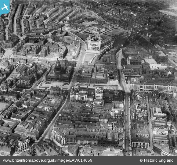
EAW014659 ENGLAND (1948). Leeds Town Hall, Municipal Buildings and environs, Leeds, 1948
© Copyright OpenStreetMap contributors and licensed by the OpenStreetMap Foundation. 2025. Cartography is licensed as CC BY-SA.
Nearby Images (15)
Details
| Title | [EAW014659] Leeds Town Hall, Municipal Buildings and environs, Leeds, 1948 |
| Reference | EAW014659 |
| Date | 21-April-1948 |
| Link | |
| Place name | LEEDS |
| Parish | |
| District | |
| Country | ENGLAND |
| Easting / Northing | 429833, 433836 |
| Longitude / Latitude | -1.5470044623587, 53.799756357839 |
| National Grid Reference | SE298338 |
Pins
 redmist |
Monday 4th of October 2021 08:37:18 PM | |
 spugs |
Thursday 2nd of October 2014 10:57:40 PM |
User Comment Contributions
 spugs |
Wednesday 8th of October 2014 07:47:40 PM | |
Central Higher Grade School later City of Leeds school, now council offices. There is a board in the entrance which states that the school admitted some boys who were refugees from Belgium as pupils during WW1. Also some soldiers from the Serbian army had English lessons there. |
 spugs |
Wednesday 8th of October 2014 07:47:40 PM |


![[EAW014659] Leeds Town Hall, Municipal Buildings and environs, Leeds, 1948](http://britainfromabove.org.uk/sites/all/libraries/aerofilms-images/public/100x100/EAW/014/EAW014659.jpg)
![[EAW015998] The Headrow and environs, Leeds, 1948. This image has been produced from a print.](http://britainfromabove.org.uk/sites/all/libraries/aerofilms-images/public/100x100/EAW/015/EAW015998.jpg)
![[EAW015997] East Parade and the city centre, Leeds, 1948. This image has been produced from a print.](http://britainfromabove.org.uk/sites/all/libraries/aerofilms-images/public/100x100/EAW/015/EAW015997.jpg)
![[EPW015898] The junction of Calverley Street and Great George Street and environs, Leeds, 1926. This image has been produced from a print.](http://britainfromabove.org.uk/sites/all/libraries/aerofilms-images/public/100x100/EPW/015/EPW015898.jpg)
![[EAW014660] Leeds Town Hall, Civic Hall and environs, Leeds, 1948](http://britainfromabove.org.uk/sites/all/libraries/aerofilms-images/public/100x100/EAW/014/EAW014660.jpg)
![[EPW057200] The city centre, Leeds, 1938. This image has been produced from a copy-negative.](http://britainfromabove.org.uk/sites/all/libraries/aerofilms-images/public/100x100/EPW/057/EPW057200.jpg)
![[EPW057199] The Civic Hall, the Town Hall and The Headrow, Leeds, 1938. This image has been affected by flare.](http://britainfromabove.org.uk/sites/all/libraries/aerofilms-images/public/100x100/EPW/057/EPW057199.jpg)
![[EPW015896] Park Square and environs, Leeds, 1926. This image has been produced from a print.](http://britainfromabove.org.uk/sites/all/libraries/aerofilms-images/public/100x100/EPW/015/EPW015896.jpg)
![[EPW043168] Leeds Civic Hall, Leeds, 1933](http://britainfromabove.org.uk/sites/all/libraries/aerofilms-images/public/100x100/EPW/043/EPW043168.jpg)
![[EAW015994] The Town Hall and surrounding city centre, Leeds, 1948. This image has been produced from a print.](http://britainfromabove.org.uk/sites/all/libraries/aerofilms-images/public/100x100/EAW/015/EAW015994.jpg)
![[EAW014658] Leeds Civic Hall, General Infirmary and environs, Leeds, 1948](http://britainfromabove.org.uk/sites/all/libraries/aerofilms-images/public/100x100/EAW/014/EAW014658.jpg)
![[EAW015738] The Headrow and the city centre, Leeds, 1948](http://britainfromabove.org.uk/sites/all/libraries/aerofilms-images/public/100x100/EAW/015/EAW015738.jpg)
![[EAW015993] Leeds Civic Hall, Leeds General Infirmary and environs, Leeds, 1948. This image has been produced from a print.](http://britainfromabove.org.uk/sites/all/libraries/aerofilms-images/public/100x100/EAW/015/EAW015993.jpg)
![[EAW014661] The Civic Hall and environs, Leeds, 1948](http://britainfromabove.org.uk/sites/all/libraries/aerofilms-images/public/100x100/EAW/014/EAW014661.jpg)
![[EPW052168] The Civic Hall, Leeds, 1936. This image has been produced from a copy-negative.](http://britainfromabove.org.uk/sites/all/libraries/aerofilms-images/public/100x100/EPW/052/EPW052168.jpg)
