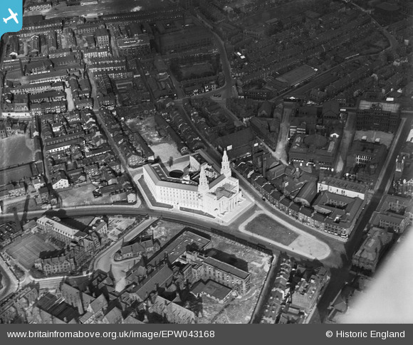
EPW043168 ENGLAND (1933). Leeds Civic Hall, Leeds, 1933
© Copyright OpenStreetMap contributors and licensed by the OpenStreetMap Foundation. 2025. Cartography is licensed as CC BY-SA.
Nearby Images (19)
Details
| Title | [EPW043168] Leeds Civic Hall, Leeds, 1933 |
| Reference | EPW043168 |
| Date | September-1933 |
| Link | |
| Place name | LEEDS |
| Parish | |
| District | |
| Country | ENGLAND |
| Easting / Northing | 429800, 434000 |
| Longitude / Latitude | -1.5474896589113, 53.801232400836 |
| National Grid Reference | SE298340 |
Pins
Be the first to add a comment to this image!


![[EPW043168] Leeds Civic Hall, Leeds, 1933](http://britainfromabove.org.uk/sites/all/libraries/aerofilms-images/public/100x100/EPW/043/EPW043168.jpg)
![[EAW015994] The Town Hall and surrounding city centre, Leeds, 1948. This image has been produced from a print.](http://britainfromabove.org.uk/sites/all/libraries/aerofilms-images/public/100x100/EAW/015/EAW015994.jpg)
![[EAW014661] The Civic Hall and environs, Leeds, 1948](http://britainfromabove.org.uk/sites/all/libraries/aerofilms-images/public/100x100/EAW/014/EAW014661.jpg)
![[EAW014660] Leeds Town Hall, Civic Hall and environs, Leeds, 1948](http://britainfromabove.org.uk/sites/all/libraries/aerofilms-images/public/100x100/EAW/014/EAW014660.jpg)
![[EPW052168] The Civic Hall, Leeds, 1936. This image has been produced from a copy-negative.](http://britainfromabove.org.uk/sites/all/libraries/aerofilms-images/public/100x100/EPW/052/EPW052168.jpg)
![[EAW015993] Leeds Civic Hall, Leeds General Infirmary and environs, Leeds, 1948. This image has been produced from a print.](http://britainfromabove.org.uk/sites/all/libraries/aerofilms-images/public/100x100/EAW/015/EAW015993.jpg)
![[EAW014658] Leeds Civic Hall, General Infirmary and environs, Leeds, 1948](http://britainfromabove.org.uk/sites/all/libraries/aerofilms-images/public/100x100/EAW/014/EAW014658.jpg)
![[EPW043169] Leeds Civic Hall, Leeds, 1933](http://britainfromabove.org.uk/sites/all/libraries/aerofilms-images/public/100x100/EPW/043/EPW043169.jpg)
![[EAW014659] Leeds Town Hall, Municipal Buildings and environs, Leeds, 1948](http://britainfromabove.org.uk/sites/all/libraries/aerofilms-images/public/100x100/EAW/014/EAW014659.jpg)
![[EPW015898] The junction of Calverley Street and Great George Street and environs, Leeds, 1926. This image has been produced from a print.](http://britainfromabove.org.uk/sites/all/libraries/aerofilms-images/public/100x100/EPW/015/EPW015898.jpg)
![[EPW057199] The Civic Hall, the Town Hall and The Headrow, Leeds, 1938. This image has been affected by flare.](http://britainfromabove.org.uk/sites/all/libraries/aerofilms-images/public/100x100/EPW/057/EPW057199.jpg)
![[EAW013812] The General Infirmary, St George's Church and the School of Dentistry, Leeds, 1948](http://britainfromabove.org.uk/sites/all/libraries/aerofilms-images/public/100x100/EAW/013/EAW013812.jpg)
![[EPW057200] The city centre, Leeds, 1938. This image has been produced from a copy-negative.](http://britainfromabove.org.uk/sites/all/libraries/aerofilms-images/public/100x100/EPW/057/EPW057200.jpg)
![[EPW057196] The General Infirmary, the Civic Hall and the city centre, Leeds, 1938](http://britainfromabove.org.uk/sites/all/libraries/aerofilms-images/public/100x100/EPW/057/EPW057196.jpg)
![[EAW015998] The Headrow and environs, Leeds, 1948. This image has been produced from a print.](http://britainfromabove.org.uk/sites/all/libraries/aerofilms-images/public/100x100/EAW/015/EAW015998.jpg)
![[EAW015997] East Parade and the city centre, Leeds, 1948. This image has been produced from a print.](http://britainfromabove.org.uk/sites/all/libraries/aerofilms-images/public/100x100/EAW/015/EAW015997.jpg)
![[EAW013813] The General Infirmary, St George's Church and the School of Dentistry, Leeds, 1948](http://britainfromabove.org.uk/sites/all/libraries/aerofilms-images/public/100x100/EAW/013/EAW013813.jpg)
![[EAW013810] The General Infirmary, St George's Church and the surrounding residential area, Leeds, 1948](http://britainfromabove.org.uk/sites/all/libraries/aerofilms-images/public/100x100/EAW/013/EAW013810.jpg)
![[EAW015738] The Headrow and the city centre, Leeds, 1948](http://britainfromabove.org.uk/sites/all/libraries/aerofilms-images/public/100x100/EAW/015/EAW015738.jpg)