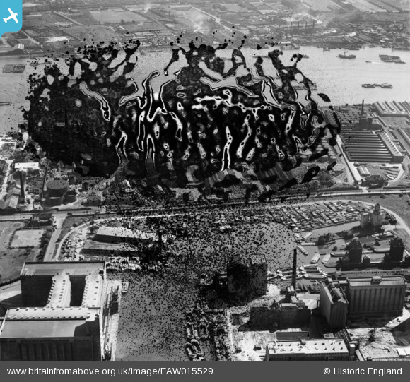
EAW015529 ENGLAND (1948). Victoria Graving Dock (Pontoon Dock) and the River Thames, Silvertown, 1948. This image has been produced from a damaged negative.
© Copyright OpenStreetMap contributors and licensed by the OpenStreetMap Foundation. 2025. Cartography is licensed as CC BY-SA.
Nearby Images (18)
Details
| Title | [EAW015529] Victoria Graving Dock (Pontoon Dock) and the River Thames, Silvertown, 1948. This image has been produced from a damaged negative. |
| Reference | EAW015529 |
| Date | 14-May-1948 |
| Link | |
| Place name | SILVERTOWN |
| Parish | |
| District | |
| Country | ENGLAND |
| Easting / Northing | 541160, 180068 |
| Longitude / Latitude | 0.033986359308018, 51.501413621182 |
| National Grid Reference | TQ412801 |
Pins
 Class31 |
Saturday 28th of February 2015 08:54:49 AM |


![[EAW015529] Victoria Graving Dock (Pontoon Dock) and the River Thames, Silvertown, 1948. This image has been produced from a damaged negative.](http://britainfromabove.org.uk/sites/all/libraries/aerofilms-images/public/100x100/EAW/015/EAW015529.jpg)
![[EAW015523] Victoria Graving Dock (Pontoon Dock) and the River Thames, Silvertown, 1948. This image has been produced from a damaged negative.](http://britainfromabove.org.uk/sites/all/libraries/aerofilms-images/public/100x100/EAW/015/EAW015523.jpg)
![[EAW015528] Victoria Graving Dock (site of) and the River Thames, Silvertown, 1948. This image has been produced from a damaged negative.](http://britainfromabove.org.uk/sites/all/libraries/aerofilms-images/public/100x100/EAW/015/EAW015528.jpg)
![[EAW015532] Victoria Graving Dock (Pontoon Dock) and environs, Silvertown, 1948. This image has been produced from a damaged negative.](http://britainfromabove.org.uk/sites/all/libraries/aerofilms-images/public/100x100/EAW/015/EAW015532.jpg)
![[EAW015530] Victoria Graving Dock (Pontoon Dock) and environs, Silvertown, 1948. This image has been produced from a damaged negative.](http://britainfromabove.org.uk/sites/all/libraries/aerofilms-images/public/100x100/EAW/015/EAW015530.jpg)
![[EAW015531] Victoria Graving Dock (Pontoon Dock) and environs, Silvertown, 1948. This image has been produced from a damaged negative.](http://britainfromabove.org.uk/sites/all/libraries/aerofilms-images/public/100x100/EAW/015/EAW015531.jpg)
![[EAW015527] Millennium Mills, Victoria Graving Dock (Pontoon Dock) and the River Thames, Silvertown, 1948. This image has been produced from a damaged negative.](http://britainfromabove.org.uk/sites/all/libraries/aerofilms-images/public/100x100/EAW/015/EAW015527.jpg)
![[EAW035966] Premier and Millenium Mills at Royal Victoria Dock looking towards the River Thames, Silvertown, 1951. This image has been produced from a print marked by Aerofilms Ltd for photo editing.](http://britainfromabove.org.uk/sites/all/libraries/aerofilms-images/public/100x100/EAW/035/EAW035966.jpg)
![[EAW015522] Victoria Graving Dock (Pontoon Dock), Silvertown, 1948. This image has been produced from a damaged negative.](http://britainfromabove.org.uk/sites/all/libraries/aerofilms-images/public/100x100/EAW/015/EAW015522.jpg)
![[EAW015524] Victoria Graving Dock (Pontoon Dock), Silvertown, 1948. This image has been produced from a damaged negative.](http://britainfromabove.org.uk/sites/all/libraries/aerofilms-images/public/100x100/EAW/015/EAW015524.jpg)
![[EPW024235] Minoco Wharf and environs, Silvertown, 1928](http://britainfromabove.org.uk/sites/all/libraries/aerofilms-images/public/100x100/EPW/024/EPW024235.jpg)
![[EAW015526] Victoria Graving Dock (site of), Silvertown, 1948. This image has been produced from a damaged negative.](http://britainfromabove.org.uk/sites/all/libraries/aerofilms-images/public/100x100/EAW/015/EAW015526.jpg)
![[EAW015525] Victoria Graving Dock (Pontoon Dock), Silvertown, 1948. This image has been produced from a damaged negative.](http://britainfromabove.org.uk/sites/all/libraries/aerofilms-images/public/100x100/EAW/015/EAW015525.jpg)
![[EAW035764] The Joseph Rank Ltd Premier Mill under reconstruction at Royal Victoria Dock, Silvertown, 1951. This image has been produced from a print marked by Aerofilms Ltd for photo editing.](http://britainfromabove.org.uk/sites/all/libraries/aerofilms-images/public/100x100/EAW/035/EAW035764.jpg)
![[EPW009694] Minoco Wharf, Silvertown, 1923](http://britainfromabove.org.uk/sites/all/libraries/aerofilms-images/public/100x100/EPW/009/EPW009694.jpg)
![[EPW009695] Minoco Wharf, Silvertown, 1923](http://britainfromabove.org.uk/sites/all/libraries/aerofilms-images/public/100x100/EPW/009/EPW009695.jpg)
![[EPW009693] Minoco Wharf, Silvertown, 1923](http://britainfromabove.org.uk/sites/all/libraries/aerofilms-images/public/100x100/EPW/009/EPW009693.jpg)
![[EPW009698] Minoco Wharf, Silvertown, 1923](http://britainfromabove.org.uk/sites/all/libraries/aerofilms-images/public/100x100/EPW/009/EPW009698.jpg)