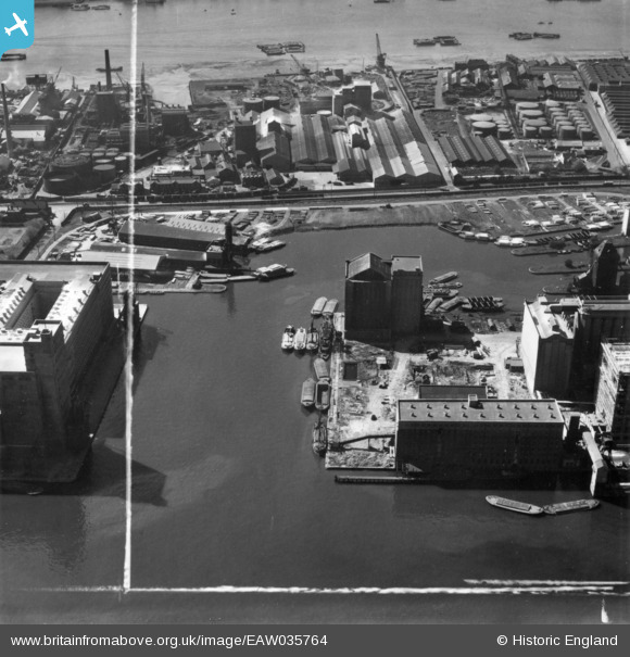
EAW035764 ENGLAND (1951). The Joseph Rank Ltd Premier Mill under reconstruction at Royal Victoria Dock, Silvertown, 1951. This image has been produced from a print marked by Aerofilms Ltd for photo editing.
© Copyright OpenStreetMap contributors and licensed by the OpenStreetMap Foundation. 2025. Cartography is licensed as CC BY-SA.
Nearby Images (40)
Details
| Title | [EAW035764] The Joseph Rank Ltd Premier Mill under reconstruction at Royal Victoria Dock, Silvertown, 1951. This image has been produced from a print marked by Aerofilms Ltd for photo editing. |
| Reference | EAW035764 |
| Date | 12-May-1951 |
| Link | |
| Place name | SILVERTOWN |
| Parish | |
| District | |
| Country | ENGLAND |
| Easting / Northing | 541166, 180314 |
| Longitude / Latitude | 0.034171220806841, 51.50362288286 |
| National Grid Reference | TQ412803 |
Pins
 Class31 |
Thursday 19th of February 2015 11:15:45 AM |


![[EAW035764] The Joseph Rank Ltd Premier Mill under reconstruction at Royal Victoria Dock, Silvertown, 1951. This image has been produced from a print marked by Aerofilms Ltd for photo editing.](http://britainfromabove.org.uk/sites/all/libraries/aerofilms-images/public/100x100/EAW/035/EAW035764.jpg)
![[EAW015526] Victoria Graving Dock (site of), Silvertown, 1948. This image has been produced from a damaged negative.](http://britainfromabove.org.uk/sites/all/libraries/aerofilms-images/public/100x100/EAW/015/EAW015526.jpg)
![[EAW035968] Premier and Millenium Mills at Royal Victoria Dock, Silvertown, 1951. This image has been produced from a print marked by Aerofilms Ltd for photo editing.](http://britainfromabove.org.uk/sites/all/libraries/aerofilms-images/public/100x100/EAW/035/EAW035968.jpg)
![[EAW035964] Premier and Millenium Mills at Royal Victoria Dock, Silvertown, 1951. This image has been produced from a print marked by Aerofilms Ltd for photo editing.](http://britainfromabove.org.uk/sites/all/libraries/aerofilms-images/public/100x100/EAW/035/EAW035964.jpg)
![[EAW035961] Premier and Millenium Mills at Royal Victoria Dock, Silvertown, 1951. This image has been produced from a print marked by Aerofilms Ltd for photo editing.](http://britainfromabove.org.uk/sites/all/libraries/aerofilms-images/public/100x100/EAW/035/EAW035961.jpg)
![[EAW035761] The Joseph Rank Ltd Premier Mill under reconstruction at Royal Victoria Dock, Silvertown, 1951. This image has been produced from a print marked by Aerofilms Ltd for photo editing.](http://britainfromabove.org.uk/sites/all/libraries/aerofilms-images/public/100x100/EAW/035/EAW035761.jpg)
![[EAW035965] Premier and Millenium Mills at Royal Victoria Dock, Silvertown, 1951. This image has been produced from a print marked by Aerofilms Ltd for photo editing.](http://britainfromabove.org.uk/sites/all/libraries/aerofilms-images/public/100x100/EAW/035/EAW035965.jpg)
![[EAW035760] The Joseph Rank Ltd Premier Mill under reconstruction at Royal Victoria Dock, Silvertown, 1951. This image has been produced from a print marked by Aerofilms Ltd for photo editing.](http://britainfromabove.org.uk/sites/all/libraries/aerofilms-images/public/100x100/EAW/035/EAW035760.jpg)
![[EAW015522] Victoria Graving Dock (Pontoon Dock), Silvertown, 1948. This image has been produced from a damaged negative.](http://britainfromabove.org.uk/sites/all/libraries/aerofilms-images/public/100x100/EAW/015/EAW015522.jpg)
![[EAW015524] Victoria Graving Dock (Pontoon Dock), Silvertown, 1948. This image has been produced from a damaged negative.](http://britainfromabove.org.uk/sites/all/libraries/aerofilms-images/public/100x100/EAW/015/EAW015524.jpg)
![[EAW035966] Premier and Millenium Mills at Royal Victoria Dock looking towards the River Thames, Silvertown, 1951. This image has been produced from a print marked by Aerofilms Ltd for photo editing.](http://britainfromabove.org.uk/sites/all/libraries/aerofilms-images/public/100x100/EAW/035/EAW035966.jpg)
![[EPW053024] The Millennium and Premier Mills at Royal Victoria Dock, Silvertown, 1937](http://britainfromabove.org.uk/sites/all/libraries/aerofilms-images/public/100x100/EPW/053/EPW053024.jpg)
![[EAW035967] Premier and Millenium Mills at Royal Victoria Dock, Silvertown, 1951. This image has been produced from a print marked by Aerofilms Ltd for photo editing.](http://britainfromabove.org.uk/sites/all/libraries/aerofilms-images/public/100x100/EAW/035/EAW035967.jpg)
![[EAW015525] Victoria Graving Dock (Pontoon Dock), Silvertown, 1948. This image has been produced from a damaged negative.](http://britainfromabove.org.uk/sites/all/libraries/aerofilms-images/public/100x100/EAW/015/EAW015525.jpg)
![[EPW005308] Premier and Millennium Mills at Royal Victoria Dock, Custom House, 1921](http://britainfromabove.org.uk/sites/all/libraries/aerofilms-images/public/100x100/EPW/005/EPW005308.jpg)
![[EAW015527] Millennium Mills, Victoria Graving Dock (Pontoon Dock) and the River Thames, Silvertown, 1948. This image has been produced from a damaged negative.](http://britainfromabove.org.uk/sites/all/libraries/aerofilms-images/public/100x100/EAW/015/EAW015527.jpg)
![[EAW015531] Victoria Graving Dock (Pontoon Dock) and environs, Silvertown, 1948. This image has been produced from a damaged negative.](http://britainfromabove.org.uk/sites/all/libraries/aerofilms-images/public/100x100/EAW/015/EAW015531.jpg)
![[EAW035762] The Joseph Rank Ltd Premier Mill and Spillers Ltd Millenium Mills under reconstruction at Royal Victoria Dock, Silvertown, 1951. This image has been produced from a print marked by Aerofilms Ltd for photo editing.](http://britainfromabove.org.uk/sites/all/libraries/aerofilms-images/public/100x100/EAW/035/EAW035762.jpg)
![[EAW015532] Victoria Graving Dock (Pontoon Dock) and environs, Silvertown, 1948. This image has been produced from a damaged negative.](http://britainfromabove.org.uk/sites/all/libraries/aerofilms-images/public/100x100/EAW/015/EAW015532.jpg)
![[EAW035962] Premier and Millenium Mills at Royal Victoria Dock, Silvertown, 1951. This image has been produced from a print marked by Aerofilms Ltd for photo editing.](http://britainfromabove.org.uk/sites/all/libraries/aerofilms-images/public/100x100/EAW/035/EAW035962.jpg)
![[EPW053023] The Millennium and Premier Mills at Pontoon Dock, Silvertown, 1937](http://britainfromabove.org.uk/sites/all/libraries/aerofilms-images/public/100x100/EPW/053/EPW053023.jpg)
![[EAW035963] Premier and Millenium Mills at Royal Victoria Dock, Silvertown, 1951. This image has been produced from a print marked by Aerofilms Ltd for photo editing.](http://britainfromabove.org.uk/sites/all/libraries/aerofilms-images/public/100x100/EAW/035/EAW035963.jpg)
![[EAW035763] The Joseph Rank Ltd Premier Mill and Spillers Ltd Millenium Mills under reconstruction at Royal Victoria Dock, Silvertown, 1951. This image has been produced from a print marked by Aerofilms Ltd for photo editing.](http://britainfromabove.org.uk/sites/all/libraries/aerofilms-images/public/100x100/EAW/035/EAW035763.jpg)
![[EPW053027] The Millennium and Premier Mills at Royal Victoria Dock and environs, Silvertown, 1937](http://britainfromabove.org.uk/sites/all/libraries/aerofilms-images/public/100x100/EPW/053/EPW053027.jpg)
![[EPW053179] The Millennium and Premier Mills at Royal Victoria Dock, Silvertown, 1937](http://britainfromabove.org.uk/sites/all/libraries/aerofilms-images/public/100x100/EPW/053/EPW053179.jpg)
![[EAW015530] Victoria Graving Dock (Pontoon Dock) and environs, Silvertown, 1948. This image has been produced from a damaged negative.](http://britainfromabove.org.uk/sites/all/libraries/aerofilms-images/public/100x100/EAW/015/EAW015530.jpg)
![[EAW015528] Victoria Graving Dock (site of) and the River Thames, Silvertown, 1948. This image has been produced from a damaged negative.](http://britainfromabove.org.uk/sites/all/libraries/aerofilms-images/public/100x100/EAW/015/EAW015528.jpg)
![[EPW053182] The Millennium and Premier Mills at Royal Victoria Dock, Silvertown, 1937](http://britainfromabove.org.uk/sites/all/libraries/aerofilms-images/public/100x100/EPW/053/EPW053182.jpg)
![[EPW044123] The Royal Group of Docks and the River Thames, East Ham, 1934](http://britainfromabove.org.uk/sites/all/libraries/aerofilms-images/public/100x100/EPW/044/EPW044123.jpg)
![[EAW015523] Victoria Graving Dock (Pontoon Dock) and the River Thames, Silvertown, 1948. This image has been produced from a damaged negative.](http://britainfromabove.org.uk/sites/all/libraries/aerofilms-images/public/100x100/EAW/015/EAW015523.jpg)
![[EAW021715] The Royal Victoria Dock, Silvertown, 1949. This image has been produced from a print.](http://britainfromabove.org.uk/sites/all/libraries/aerofilms-images/public/100x100/EAW/021/EAW021715.jpg)
![[EPW053181] The Millennium and Premier Mills at Royal Victoria Dock, Silvertown, 1937](http://britainfromabove.org.uk/sites/all/libraries/aerofilms-images/public/100x100/EPW/053/EPW053181.jpg)
![[EPW053180] The Millennium and Premier Mills at Royal Victoria Dock, Silvertown, 1937](http://britainfromabove.org.uk/sites/all/libraries/aerofilms-images/public/100x100/EPW/053/EPW053180.jpg)
![[EPW008883] The Royal Victoria Dock, Silvertown, 1923. This image has been produced from a print.](http://britainfromabove.org.uk/sites/all/libraries/aerofilms-images/public/100x100/EPW/008/EPW008883.jpg)
![[EPW053056] The Millennium and Premier Mills at Royal Victoria Dock, Silvertown, 1937](http://britainfromabove.org.uk/sites/all/libraries/aerofilms-images/public/100x100/EPW/053/EPW053056.jpg)
![[EAW015529] Victoria Graving Dock (Pontoon Dock) and the River Thames, Silvertown, 1948. This image has been produced from a damaged negative.](http://britainfromabove.org.uk/sites/all/libraries/aerofilms-images/public/100x100/EAW/015/EAW015529.jpg)
![[EPW053026] The Millennium and Premier Mills at Royal Victoria Dock and environs, Silvertown, 1937](http://britainfromabove.org.uk/sites/all/libraries/aerofilms-images/public/100x100/EPW/053/EPW053026.jpg)
![[EPW053025] The Millennium and Premier Mills at Royal Victoria Dock and environs, Silvertown, 1937](http://britainfromabove.org.uk/sites/all/libraries/aerofilms-images/public/100x100/EPW/053/EPW053025.jpg)
![[EPW059357A] The Royal Victoria Dock, Silvertown, 1938](http://britainfromabove.org.uk/sites/all/libraries/aerofilms-images/public/100x100/EPW/059/EPW059357A.jpg)
![[EAW616990] The Royal Victoria and Royal Albert Docks, London, 1992](http://britainfromabove.org.uk/sites/all/libraries/aerofilms-images/public/100x100/EAW/616/EAW616990.jpg)