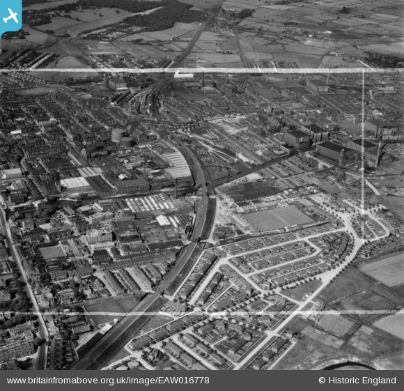
EAW016778 ENGLAND (1948). The Bedford Leigh railway embankment, the Anchor Electric Cable Works and environs, Leigh, 1948. This image was marked by Aerofilms Ltd for photo editing.
© Copyright OpenStreetMap contributors and licensed by the OpenStreetMap Foundation. 2025. Cartography is licensed as CC BY-SA.
Nearby Images (19)
Details
| Title | [EAW016778] The Bedford Leigh railway embankment, the Anchor Electric Cable Works and environs, Leigh, 1948. This image was marked by Aerofilms Ltd for photo editing. |
| Reference | EAW016778 |
| Date | 23-June-1948 |
| Link | |
| Place name | LEIGH |
| Parish | |
| District | |
| Country | ENGLAND |
| Easting / Northing | 365943, 399689 |
| Longitude / Latitude | -2.5133900309421, 53.492553752021 |
| National Grid Reference | SJ659997 |


![[EAW016778] The Bedford Leigh railway embankment, the Anchor Electric Cable Works and environs, Leigh, 1948. This image was marked by Aerofilms Ltd for photo editing.](http://britainfromabove.org.uk/sites/all/libraries/aerofilms-images/public/100x100/EAW/016/EAW016778.jpg)
![[EAW016780] The Bridgewater Canal, the Anchor Electric Cable Works and environs, Leigh, 1948. This image was marked by Aerofilms Ltd for photo editing.](http://britainfromabove.org.uk/sites/all/libraries/aerofilms-images/public/100x100/EAW/016/EAW016780.jpg)
![[EAW016784] Siddow Common football ground and the Anchor Electric Cable Works, Leigh, 1948](http://britainfromabove.org.uk/sites/all/libraries/aerofilms-images/public/100x100/EAW/016/EAW016784.jpg)
![[EPW031119] Harrison, McGregor and Co Ltd Albion Engineering Works, Leigh, 1929](http://britainfromabove.org.uk/sites/all/libraries/aerofilms-images/public/100x100/EPW/031/EPW031119.jpg)
![[EPW031125] Harrison, McGregor and Co Ltd Albion Engineering Works, Leigh, 1929](http://britainfromabove.org.uk/sites/all/libraries/aerofilms-images/public/100x100/EPW/031/EPW031125.jpg)
![[EAW016783] The Anchor Electric Cable Works, Bridgewater Canal and environs, Leigh, 1948](http://britainfromabove.org.uk/sites/all/libraries/aerofilms-images/public/100x100/EAW/016/EAW016783.jpg)
![[EPW062124] The Anchor Electric Cable Works and the Football Ground at Siddow Common, Leigh, 1939](http://britainfromabove.org.uk/sites/all/libraries/aerofilms-images/public/100x100/EPW/062/EPW062124.jpg)
![[EPW062119] The Anchor Electric Cable Works and the Albion Engineering Works, Leigh, 1939](http://britainfromabove.org.uk/sites/all/libraries/aerofilms-images/public/100x100/EPW/062/EPW062119.jpg)
![[EPW062121] The Anchor Electric Cable Works and the Albion Engineering Works, Leigh, 1939](http://britainfromabove.org.uk/sites/all/libraries/aerofilms-images/public/100x100/EPW/062/EPW062121.jpg)
![[EAW016786] The Anchor Electric Cable Works and environs, Leigh, 1948](http://britainfromabove.org.uk/sites/all/libraries/aerofilms-images/public/100x100/EAW/016/EAW016786.jpg)
![[EPW062123] The Anchor Electric Cable Works and the Albion Engineering Works, Leigh, 1939](http://britainfromabove.org.uk/sites/all/libraries/aerofilms-images/public/100x100/EPW/062/EPW062123.jpg)
![[EAW016779] Siddow Common football ground and environs, Leigh, 1948](http://britainfromabove.org.uk/sites/all/libraries/aerofilms-images/public/100x100/EAW/016/EAW016779.jpg)
![[EAW016777] West Bridgewater Street, the Anchor Electric Cable Works, Bridgewater Canal and environs, Leigh, 1948. This image was marked by Aerofilms Ltd for photo editing.](http://britainfromabove.org.uk/sites/all/libraries/aerofilms-images/public/100x100/EAW/016/EAW016777.jpg)
![[EPW062125] The Anchor Electric Cable Works and the Albion Engineering Works, Leigh, 1939](http://britainfromabove.org.uk/sites/all/libraries/aerofilms-images/public/100x100/EPW/062/EPW062125.jpg)
![[EAW016781] West Bridgewater Street, the Anchor Electric Cable Works, Bridgewater Canal and environs, Leigh, 1948](http://britainfromabove.org.uk/sites/all/libraries/aerofilms-images/public/100x100/EAW/016/EAW016781.jpg)
![[EAW016776] The Anchor Electric Cable Works, Bridgewater Canal and environs, Leigh, 1948. This image was marked by Aerofilms Ltd for photo editing.](http://britainfromabove.org.uk/sites/all/libraries/aerofilms-images/public/100x100/EAW/016/EAW016776.jpg)
![[EAW016785] The Anchor Electric Cable Works and environs, Leigh, 1948](http://britainfromabove.org.uk/sites/all/libraries/aerofilms-images/public/100x100/EAW/016/EAW016785.jpg)
![[EPW062120] The Anchor Electric Cable Works and the town centre, Leigh, 1939](http://britainfromabove.org.uk/sites/all/libraries/aerofilms-images/public/100x100/EPW/062/EPW062120.jpg)
![[EPW062118] The Anchor Electric Cable Works and the town centre, Leigh, 1939. This image has been affected by flare.](http://britainfromabove.org.uk/sites/all/libraries/aerofilms-images/public/100x100/EPW/062/EPW062118.jpg)
