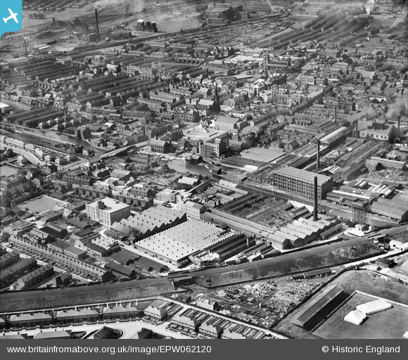
EPW062120 ENGLAND (1939). The Anchor Electric Cable Works and the town centre, Leigh, 1939
© Copyright OpenStreetMap contributors and licensed by the OpenStreetMap Foundation. 2025. Cartography is licensed as CC BY-SA.
Nearby Images (20)
Details
| Title | [EPW062120] The Anchor Electric Cable Works and the town centre, Leigh, 1939 |
| Reference | EPW062120 |
| Date | 30-June-1939 |
| Link | |
| Place name | LEIGH |
| Parish | |
| District | |
| Country | ENGLAND |
| Easting / Northing | 365695, 399783 |
| Longitude / Latitude | -2.5171386040326, 53.493382613345 |
| National Grid Reference | SJ657998 |


![[EPW062120] The Anchor Electric Cable Works and the town centre, Leigh, 1939](http://britainfromabove.org.uk/sites/all/libraries/aerofilms-images/public/100x100/EPW/062/EPW062120.jpg)
![[EPW062122] The Anchor Electric Cable Works and the town centre, Leigh, 1939](http://britainfromabove.org.uk/sites/all/libraries/aerofilms-images/public/100x100/EPW/062/EPW062122.jpg)
![[EPW062118] The Anchor Electric Cable Works and the town centre, Leigh, 1939. This image has been affected by flare.](http://britainfromabove.org.uk/sites/all/libraries/aerofilms-images/public/100x100/EPW/062/EPW062118.jpg)
![[EAW016782] The Anchor Electric Cable Works, Bridgewater Canal and environs, Leigh, 1948](http://britainfromabove.org.uk/sites/all/libraries/aerofilms-images/public/100x100/EAW/016/EAW016782.jpg)
![[EAW016777] West Bridgewater Street, the Anchor Electric Cable Works, Bridgewater Canal and environs, Leigh, 1948. This image was marked by Aerofilms Ltd for photo editing.](http://britainfromabove.org.uk/sites/all/libraries/aerofilms-images/public/100x100/EAW/016/EAW016777.jpg)
![[EPW062121] The Anchor Electric Cable Works and the Albion Engineering Works, Leigh, 1939](http://britainfromabove.org.uk/sites/all/libraries/aerofilms-images/public/100x100/EPW/062/EPW062121.jpg)
![[EAW016786] The Anchor Electric Cable Works and environs, Leigh, 1948](http://britainfromabove.org.uk/sites/all/libraries/aerofilms-images/public/100x100/EAW/016/EAW016786.jpg)
![[EAW016781] West Bridgewater Street, the Anchor Electric Cable Works, Bridgewater Canal and environs, Leigh, 1948](http://britainfromabove.org.uk/sites/all/libraries/aerofilms-images/public/100x100/EAW/016/EAW016781.jpg)
![[EPW062125] The Anchor Electric Cable Works and the Albion Engineering Works, Leigh, 1939](http://britainfromabove.org.uk/sites/all/libraries/aerofilms-images/public/100x100/EPW/062/EPW062125.jpg)
![[EPW062119] The Anchor Electric Cable Works and the Albion Engineering Works, Leigh, 1939](http://britainfromabove.org.uk/sites/all/libraries/aerofilms-images/public/100x100/EPW/062/EPW062119.jpg)
![[EPW062123] The Anchor Electric Cable Works and the Albion Engineering Works, Leigh, 1939](http://britainfromabove.org.uk/sites/all/libraries/aerofilms-images/public/100x100/EPW/062/EPW062123.jpg)
![[EPW031125] Harrison, McGregor and Co Ltd Albion Engineering Works, Leigh, 1929](http://britainfromabove.org.uk/sites/all/libraries/aerofilms-images/public/100x100/EPW/031/EPW031125.jpg)
![[EAW016776] The Anchor Electric Cable Works, Bridgewater Canal and environs, Leigh, 1948. This image was marked by Aerofilms Ltd for photo editing.](http://britainfromabove.org.uk/sites/all/libraries/aerofilms-images/public/100x100/EAW/016/EAW016776.jpg)
![[EPW062124] The Anchor Electric Cable Works and the Football Ground at Siddow Common, Leigh, 1939](http://britainfromabove.org.uk/sites/all/libraries/aerofilms-images/public/100x100/EPW/062/EPW062124.jpg)
![[EPW031119] Harrison, McGregor and Co Ltd Albion Engineering Works, Leigh, 1929](http://britainfromabove.org.uk/sites/all/libraries/aerofilms-images/public/100x100/EPW/031/EPW031119.jpg)
![[EAW016783] The Anchor Electric Cable Works, Bridgewater Canal and environs, Leigh, 1948](http://britainfromabove.org.uk/sites/all/libraries/aerofilms-images/public/100x100/EAW/016/EAW016783.jpg)
![[EAW016785] The Anchor Electric Cable Works and environs, Leigh, 1948](http://britainfromabove.org.uk/sites/all/libraries/aerofilms-images/public/100x100/EAW/016/EAW016785.jpg)
![[EAW016780] The Bridgewater Canal, the Anchor Electric Cable Works and environs, Leigh, 1948. This image was marked by Aerofilms Ltd for photo editing.](http://britainfromabove.org.uk/sites/all/libraries/aerofilms-images/public/100x100/EAW/016/EAW016780.jpg)
![[EPW031118] The King Street Methodist Church and surroundings, Leigh, 1929](http://britainfromabove.org.uk/sites/all/libraries/aerofilms-images/public/100x100/EPW/031/EPW031118.jpg)
![[EAW016778] The Bedford Leigh railway embankment, the Anchor Electric Cable Works and environs, Leigh, 1948. This image was marked by Aerofilms Ltd for photo editing.](http://britainfromabove.org.uk/sites/all/libraries/aerofilms-images/public/100x100/EAW/016/EAW016778.jpg)
