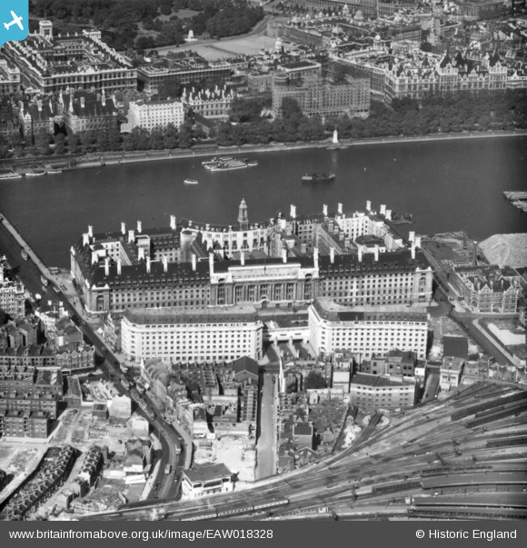
EAW018328 ENGLAND (1948). The County Hall, Lambeth, 1948. This image has been produced from a print.
© Copyright OpenStreetMap contributors and licensed by the OpenStreetMap Foundation. 2025. Cartography is licensed as CC BY-SA.
Nearby Images (45)
Details
| Title | [EAW018328] The County Hall, Lambeth, 1948. This image has been produced from a print. |
| Reference | EAW018328 |
| Date | 24-August-1948 |
| Link | |
| Place name | LAMBETH |
| Parish | |
| District | |
| Country | ENGLAND |
| Easting / Northing | 530693, 179788 |
| Longitude / Latitude | -0.11684615314724, 51.50141480055 |
| National Grid Reference | TQ307798 |
Pins
 brianbeckett |
Friday 22nd of May 2020 09:02:00 PM | |
 ken |
Wednesday 29th of July 2015 10:31:00 AM | |
 ken |
Wednesday 29th of July 2015 10:29:54 AM | |
 brianbeckett |
Tuesday 16th of September 2014 04:52:47 PM |


![[EAW018328] The County Hall, Lambeth, 1948. This image has been produced from a print.](http://britainfromabove.org.uk/sites/all/libraries/aerofilms-images/public/100x100/EAW/018/EAW018328.jpg)
![[EPW060606] The County Hall and Waterloo Railway Station, Lambeth, 1939](http://britainfromabove.org.uk/sites/all/libraries/aerofilms-images/public/100x100/EPW/060/EPW060606.jpg)
![[EPW060605] The County Hall, Lambeth, 1939](http://britainfromabove.org.uk/sites/all/libraries/aerofilms-images/public/100x100/EPW/060/EPW060605.jpg)
![[EPW019014] County Hall and Westminster Bridge, Lambeth, 1927](http://britainfromabove.org.uk/sites/all/libraries/aerofilms-images/public/100x100/EPW/019/EPW019014.jpg)
![[EAW034734] The Festival of Britain South Bank site under construction and the River Thames, Lambeth, from the south-west, 1951](http://britainfromabove.org.uk/sites/all/libraries/aerofilms-images/public/100x100/EAW/034/EAW034734.jpg)
![[EPW008116] County Hall, Lambeth, 1922. This image has been produced from a copy-negative.](http://britainfromabove.org.uk/sites/all/libraries/aerofilms-images/public/100x100/EPW/008/EPW008116.jpg)
![[EPW005603] The County Hall under construction, London, 1921](http://britainfromabove.org.uk/sites/all/libraries/aerofilms-images/public/100x100/EPW/005/EPW005603.jpg)
![[EPW060604] The County Hall, Westminster Bridge and Waterloo Railway Station, Lambeth, 1939](http://britainfromabove.org.uk/sites/all/libraries/aerofilms-images/public/100x100/EPW/060/EPW060604.jpg)
![[EPW025120] County Hall and Westminster Bridge, Lambeth, 1928. This image has been affected by flare.](http://britainfromabove.org.uk/sites/all/libraries/aerofilms-images/public/100x100/EPW/025/EPW025120.jpg)
![[EAW033385] A cityscape over the River Thames and Waterloo Railway Station, Lambeth, 1950. This image has been produced from a print.](http://britainfromabove.org.uk/sites/all/libraries/aerofilms-images/public/100x100/EAW/033/EAW033385.jpg)
![[EAW033386] A cityscape from Waterloo Railway Station, over the River Thames, towards Buckingham Palace, Lambeth, 1950. This image has been produced from a print.](http://britainfromabove.org.uk/sites/all/libraries/aerofilms-images/public/100x100/EAW/033/EAW033386.jpg)
![[EAW034736] The Festival of Britain South Bank site under construction and the River Thames, Lambeth, from the south-west, 1951](http://britainfromabove.org.uk/sites/all/libraries/aerofilms-images/public/100x100/EAW/034/EAW034736.jpg)
![[EAW034712] The South Bank area, River Thames and environs, Lambeth, from the south-west, 1951](http://britainfromabove.org.uk/sites/all/libraries/aerofilms-images/public/100x100/EAW/034/EAW034712.jpg)
![[EAW034978] The Festival of Britain South Bank Site, Lambeth, from the south-east, 1951](http://britainfromabove.org.uk/sites/all/libraries/aerofilms-images/public/100x100/EAW/034/EAW034978.jpg)
![[EAW034928] The Festival of Britain South Bank Site under construction, Lambeth, 1951. This image has been produced from a print.](http://britainfromabove.org.uk/sites/all/libraries/aerofilms-images/public/100x100/EAW/034/EAW034928.jpg)
![[EAW034673] The Dome of Discovery and Festival of Britain South Bank Site under construction, Lambeth, 1951](http://britainfromabove.org.uk/sites/all/libraries/aerofilms-images/public/100x100/EAW/034/EAW034673.jpg)
![[EAW034929] The Dome of Discovery under construction at the Festival of Britain South Bank Site, Lambeth, 1951. This image has been produced from a print.](http://britainfromabove.org.uk/sites/all/libraries/aerofilms-images/public/100x100/EAW/034/EAW034929.jpg)
![[EAW042628] Buildings on the Festival of Britain South Bank site being dismantled, Lambeth, 1952](http://britainfromabove.org.uk/sites/all/libraries/aerofilms-images/public/100x100/EAW/042/EAW042628.jpg)
![[EAW021428] County Hall, Waterloo Station and the South Bank, Lambeth, from the south-west, 1949. This image has been produced from a print.](http://britainfromabove.org.uk/sites/all/libraries/aerofilms-images/public/100x100/EAW/021/EAW021428.jpg)
![[EAW034672] The Dome of Discovery and Festival of Britain South Bank Site under construction, Lambeth, 1951](http://britainfromabove.org.uk/sites/all/libraries/aerofilms-images/public/100x100/EAW/034/EAW034672.jpg)
![[EAW034682] The Dome of Discovery and Festival of Britain South Bank Site under construction, Lambeth, 1951](http://britainfromabove.org.uk/sites/all/libraries/aerofilms-images/public/100x100/EAW/034/EAW034682.jpg)
![[EAW035663] The Festival of Britain South Bank Site, Lambeth, 1951. This image has been produced from a print.](http://britainfromabove.org.uk/sites/all/libraries/aerofilms-images/public/100x100/EAW/035/EAW035663.jpg)
![[EAW034923] The Festival of Britain South Bank Site under construction, Lambeth, 1951. This image has been produced from a print.](http://britainfromabove.org.uk/sites/all/libraries/aerofilms-images/public/100x100/EAW/034/EAW034923.jpg)
![[EAW034684] The Festival of Britain South Bank Site under construction, Lambeth, 1951](http://britainfromabove.org.uk/sites/all/libraries/aerofilms-images/public/100x100/EAW/034/EAW034684.jpg)
![[EAW035669] The Dome of Discovery at the Festival of Britain South Bank Site, Lambeth, 1951. This image has been produced from a damaged print.](http://britainfromabove.org.uk/sites/all/libraries/aerofilms-images/public/100x100/EAW/035/EAW035669.jpg)
![[EAW034735] The Festival of Britain South Bank site under construction and the River Thames, Lambeth, from the south-west, 1951](http://britainfromabove.org.uk/sites/all/libraries/aerofilms-images/public/100x100/EAW/034/EAW034735.jpg)
![[EAW048067] The Festival of Britain South Bank Site being cleared, Lambeth, 1952](http://britainfromabove.org.uk/sites/all/libraries/aerofilms-images/public/100x100/EAW/048/EAW048067.jpg)
![[EAW035702] Lambeth, crowds at the Festival of Britain South Bank Site, 1951. This image has been produced from a print.](http://britainfromabove.org.uk/sites/all/libraries/aerofilms-images/public/100x100/EAW/035/EAW035702.jpg)
![[EAW031794] The Festival of Britain South Bank site under construction, Lambeth, 1950](http://britainfromabove.org.uk/sites/all/libraries/aerofilms-images/public/100x100/EAW/031/EAW031794.jpg)
![[EAW035176] The Festival of Britain South Bank Site, the River Thames and the city, Lambeth, from the north-east, 1951](http://britainfromabove.org.uk/sites/all/libraries/aerofilms-images/public/100x100/EAW/035/EAW035176.jpg)
![[EAW046363] The Festival of Britain South Bank site being dismantled, Lambeth, 1952](http://britainfromabove.org.uk/sites/all/libraries/aerofilms-images/public/100x100/EAW/046/EAW046363.jpg)
![[EAW047025] The site of the Festival of Britain on the South Bank, Lambeth, 1952](http://britainfromabove.org.uk/sites/all/libraries/aerofilms-images/public/100x100/EAW/047/EAW047025.jpg)
![[EAW048070] The Festival of Britain South Bank Site being cleared, Lambeth, 1952](http://britainfromabove.org.uk/sites/all/libraries/aerofilms-images/public/100x100/EAW/048/EAW048070.jpg)
![[EAW031789] The Festival of Britain South Bank site under construction, Lambeth, 1950](http://britainfromabove.org.uk/sites/all/libraries/aerofilms-images/public/100x100/EAW/031/EAW031789.jpg)
![[EPW055303] Waterloo Station, the River Thames and environs, Lambeth, from the south-west, 1937](http://britainfromabove.org.uk/sites/all/libraries/aerofilms-images/public/100x100/EPW/055/EPW055303.jpg)
![[EAW043630] The Festival of Britain South Bank site and Waterloo Station, Lambeth, 1952](http://britainfromabove.org.uk/sites/all/libraries/aerofilms-images/public/100x100/EAW/043/EAW043630.jpg)
![[EAW034927] The Festival of Britain South Bank Site under construction alongside Hungerford Bridge, Lambeth, 1951. This image has been produced from a print.](http://britainfromabove.org.uk/sites/all/libraries/aerofilms-images/public/100x100/EAW/034/EAW034927.jpg)
![[EPW031872] Waterloo railway station and the River Thames from Lambeth Bridge to London Bridge, Lambeth, from the south-west, 1930](http://britainfromabove.org.uk/sites/all/libraries/aerofilms-images/public/100x100/EPW/031/EPW031872.jpg)
![[EAW035147] Part of the Festival of Britain South Bank Site (including Skylon) under construction, Lambeth, 1951. This image has been produced from a print.](http://britainfromabove.org.uk/sites/all/libraries/aerofilms-images/public/100x100/EAW/035/EAW035147.jpg)
![[EAW035654] The River Thames, Festival of Britain South Bank Site, Waterloo Station and environs, Lambeth, from the west, 1951. This image has been produced from a print.](http://britainfromabove.org.uk/sites/all/libraries/aerofilms-images/public/100x100/EAW/035/EAW035654.jpg)
![[EAW034713] The Festival of Britain South Bank site under construction, River Thames and environs, Lambeth, from the south-west, 1951](http://britainfromabove.org.uk/sites/all/libraries/aerofilms-images/public/100x100/EAW/034/EAW034713.jpg)
![[EAW035660] The Festival of Britain South Bank Site, Lambeth, from the east, 1951. This image has been produced from a damaged print.](http://britainfromabove.org.uk/sites/all/libraries/aerofilms-images/public/100x100/EAW/035/EAW035660.jpg)
![[EAW031791] The Festival of Britain South Bank site under construction, Lambeth, 1950](http://britainfromabove.org.uk/sites/all/libraries/aerofilms-images/public/100x100/EAW/031/EAW031791.jpg)
![[EPW009111] Whitehall, Westminster, 1923. This image has been produced from a print.](http://britainfromabove.org.uk/sites/all/libraries/aerofilms-images/public/100x100/EPW/009/EPW009111.jpg)
![[EAW021430] Hungerford Bridge, Waterloo Bridge and the South Bank, Lambeth, from the south-west, 1949. This image has been produced from a print.](http://britainfromabove.org.uk/sites/all/libraries/aerofilms-images/public/100x100/EAW/021/EAW021430.jpg)