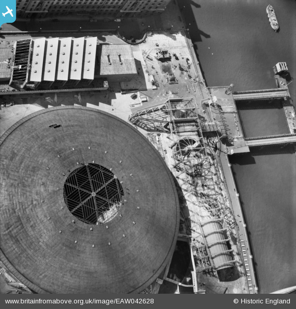
EAW042628 ENGLAND (1952). Buildings on the Festival of Britain South Bank site being dismantled, Lambeth, 1952
© Copyright OpenStreetMap contributors and licensed by the OpenStreetMap Foundation. 2025. Cartography is licensed as CC BY-SA.
Nearby Images (48)
Details
| Title | [EAW042628] Buildings on the Festival of Britain South Bank site being dismantled, Lambeth, 1952 |
| Reference | EAW042628 |
| Date | 23-April-1952 |
| Link | |
| Place name | LAMBETH |
| Parish | |
| District | |
| Country | ENGLAND |
| Easting / Northing | 530679, 179990 |
| Longitude / Latitude | -0.11697291353771, 51.503233541994 |
| National Grid Reference | TQ307800 |
Pins
 Class31 |
Wednesday 26th of November 2014 05:35:35 PM |


![[EAW042628] Buildings on the Festival of Britain South Bank site being dismantled, Lambeth, 1952](http://britainfromabove.org.uk/sites/all/libraries/aerofilms-images/public/100x100/EAW/042/EAW042628.jpg)
![[EAW034682] The Dome of Discovery and Festival of Britain South Bank Site under construction, Lambeth, 1951](http://britainfromabove.org.uk/sites/all/libraries/aerofilms-images/public/100x100/EAW/034/EAW034682.jpg)
![[EAW035663] The Festival of Britain South Bank Site, Lambeth, 1951. This image has been produced from a print.](http://britainfromabove.org.uk/sites/all/libraries/aerofilms-images/public/100x100/EAW/035/EAW035663.jpg)
![[EAW031794] The Festival of Britain South Bank site under construction, Lambeth, 1950](http://britainfromabove.org.uk/sites/all/libraries/aerofilms-images/public/100x100/EAW/031/EAW031794.jpg)
![[EAW035669] The Dome of Discovery at the Festival of Britain South Bank Site, Lambeth, 1951. This image has been produced from a damaged print.](http://britainfromabove.org.uk/sites/all/libraries/aerofilms-images/public/100x100/EAW/035/EAW035669.jpg)
![[EAW035702] Lambeth, crowds at the Festival of Britain South Bank Site, 1951. This image has been produced from a print.](http://britainfromabove.org.uk/sites/all/libraries/aerofilms-images/public/100x100/EAW/035/EAW035702.jpg)
![[EAW034928] The Festival of Britain South Bank Site under construction, Lambeth, 1951. This image has been produced from a print.](http://britainfromabove.org.uk/sites/all/libraries/aerofilms-images/public/100x100/EAW/034/EAW034928.jpg)
![[EPW060762] Central London from the Palace of Westminster towards Tower Bridge and beyond, from the west, 1939](http://britainfromabove.org.uk/sites/all/libraries/aerofilms-images/public/100x100/EPW/060/EPW060762.jpg)
![[EAW034920] The Dome of Discovery under construction at the Festival of Britain South Bank Site, Lambeth, 1951. This image has been produced from a print.](http://britainfromabove.org.uk/sites/all/libraries/aerofilms-images/public/100x100/EAW/034/EAW034920.jpg)
![[EAW034689] The Festival of Britain South Bank Site under construction, Lambeth, 1951](http://britainfromabove.org.uk/sites/all/libraries/aerofilms-images/public/100x100/EAW/034/EAW034689.jpg)
![[EAW034932] The Dome of Discovery under construction at the Festival of Britain South Bank Site, Lambeth, 1951. This image has been produced from a print.](http://britainfromabove.org.uk/sites/all/libraries/aerofilms-images/public/100x100/EAW/034/EAW034932.jpg)
![[EAW042629] Buildings on the Festival of Britain South Bank site being dismantled, Lambeth, 1952](http://britainfromabove.org.uk/sites/all/libraries/aerofilms-images/public/100x100/EAW/042/EAW042629.jpg)
![[EAW034924] The Festival of Britain South Bank Site under construction, Lambeth, 1951. This image has been produced from a print.](http://britainfromabove.org.uk/sites/all/libraries/aerofilms-images/public/100x100/EAW/034/EAW034924.jpg)
![[EAW035147] Part of the Festival of Britain South Bank Site (including Skylon) under construction, Lambeth, 1951. This image has been produced from a print.](http://britainfromabove.org.uk/sites/all/libraries/aerofilms-images/public/100x100/EAW/035/EAW035147.jpg)
![[EAW035292] The Festival of Britain South Bank Site including Skylon under construction, Lambeth, 1951. This image has been produced from a print.](http://britainfromabove.org.uk/sites/all/libraries/aerofilms-images/public/100x100/EAW/035/EAW035292.jpg)
![[EAW042627] Buildings on the Festival of Britain South Bank site being dismantled, Lambeth, 1952](http://britainfromabove.org.uk/sites/all/libraries/aerofilms-images/public/100x100/EAW/042/EAW042627.jpg)
![[EAW049399] The Festival of Britain South Bank Site, Hungerford Bridge and the River Thames, Lambeth, 1953](http://britainfromabove.org.uk/sites/all/libraries/aerofilms-images/public/100x100/EAW/049/EAW049399.jpg)
![[EAW034922] The Festival of Britain South Bank Site under construction alongside Hungerford Bridge, Lambeth, 1951. This image has been produced from a print.](http://britainfromabove.org.uk/sites/all/libraries/aerofilms-images/public/100x100/EAW/034/EAW034922.jpg)
![[EAW035176] The Festival of Britain South Bank Site, the River Thames and the city, Lambeth, from the north-east, 1951](http://britainfromabove.org.uk/sites/all/libraries/aerofilms-images/public/100x100/EAW/035/EAW035176.jpg)
![[EAW034712] The South Bank area, River Thames and environs, Lambeth, from the south-west, 1951](http://britainfromabove.org.uk/sites/all/libraries/aerofilms-images/public/100x100/EAW/034/EAW034712.jpg)
![[EAW034736] The Festival of Britain South Bank site under construction and the River Thames, Lambeth, from the south-west, 1951](http://britainfromabove.org.uk/sites/all/libraries/aerofilms-images/public/100x100/EAW/034/EAW034736.jpg)
![[EAW035674] Waterloo Station, Hungerford Bridge and the Festival of Britain South Bank Site, Lambeth, 1951. This image has been produced from a damaged print.](http://britainfromabove.org.uk/sites/all/libraries/aerofilms-images/public/100x100/EAW/035/EAW035674.jpg)
![[EAW034731] The Festival of Britain South Bank site under construction and the River Thames, Lambeth, from the south-west, 1951](http://britainfromabove.org.uk/sites/all/libraries/aerofilms-images/public/100x100/EAW/034/EAW034731.jpg)
![[EAW031796] The Festival of Britain South Bank site under construction, Lambeth, 1950](http://britainfromabove.org.uk/sites/all/libraries/aerofilms-images/public/100x100/EAW/031/EAW031796.jpg)
![[EPW031873] Waterloo railway station and the River Thames from Westminster Bridge to Tower Bridge, Lambeth, from the south-west, 1930](http://britainfromabove.org.uk/sites/all/libraries/aerofilms-images/public/100x100/EPW/031/EPW031873.jpg)
![[EAW049466] The Festival of Britain South Bank Site and Hungerford Bridge, Lambeth, 1953](http://britainfromabove.org.uk/sites/all/libraries/aerofilms-images/public/100x100/EAW/049/EAW049466.jpg)
![[EAW034713] The Festival of Britain South Bank site under construction, River Thames and environs, Lambeth, from the south-west, 1951](http://britainfromabove.org.uk/sites/all/libraries/aerofilms-images/public/100x100/EAW/034/EAW034713.jpg)
![[EAW034679] The Festival of Britain South Bank Site under construction, Lambeth, 1951](http://britainfromabove.org.uk/sites/all/libraries/aerofilms-images/public/100x100/EAW/034/EAW034679.jpg)
![[EAW049404] The Festival of Britain South Bank site, Hungerford Bridge and environs, Lambeth, from the west, 1953](http://britainfromabove.org.uk/sites/all/libraries/aerofilms-images/public/100x100/EAW/049/EAW049404.jpg)
![[EAW021430] Hungerford Bridge, Waterloo Bridge and the South Bank, Lambeth, from the south-west, 1949. This image has been produced from a print.](http://britainfromabove.org.uk/sites/all/libraries/aerofilms-images/public/100x100/EAW/021/EAW021430.jpg)
![[EPW060604] The County Hall, Westminster Bridge and Waterloo Railway Station, Lambeth, 1939](http://britainfromabove.org.uk/sites/all/libraries/aerofilms-images/public/100x100/EPW/060/EPW060604.jpg)
![[EAW049398] The Festival of Britain South Bank Site, Hungerford Bridge and the River Thames, Lambeth, 1953](http://britainfromabove.org.uk/sites/all/libraries/aerofilms-images/public/100x100/EAW/049/EAW049398.jpg)
![[EAW035654] The River Thames, Festival of Britain South Bank Site, Waterloo Station and environs, Lambeth, from the west, 1951. This image has been produced from a print.](http://britainfromabove.org.uk/sites/all/libraries/aerofilms-images/public/100x100/EAW/035/EAW035654.jpg)
![[EPW008116] County Hall, Lambeth, 1922. This image has been produced from a copy-negative.](http://britainfromabove.org.uk/sites/all/libraries/aerofilms-images/public/100x100/EPW/008/EPW008116.jpg)
![[EPW060605] The County Hall, Lambeth, 1939](http://britainfromabove.org.uk/sites/all/libraries/aerofilms-images/public/100x100/EPW/060/EPW060605.jpg)
![[EAW035667] Hungerford Bridge and the Festival of Britain South Bank Site, Lambeth, 1951. This image has been produced from a damaged print.](http://britainfromabove.org.uk/sites/all/libraries/aerofilms-images/public/100x100/EAW/035/EAW035667.jpg)
![[EPW060606] The County Hall and Waterloo Railway Station, Lambeth, 1939](http://britainfromabove.org.uk/sites/all/libraries/aerofilms-images/public/100x100/EPW/060/EPW060606.jpg)
![[EAW032225] Hungerford Bridge and the Festival of Britain South Bank Site under construction, Lambeth, 1950](http://britainfromabove.org.uk/sites/all/libraries/aerofilms-images/public/100x100/EAW/032/EAW032225.jpg)
![[EAW034734] The Festival of Britain South Bank site under construction and the River Thames, Lambeth, from the south-west, 1951](http://britainfromabove.org.uk/sites/all/libraries/aerofilms-images/public/100x100/EAW/034/EAW034734.jpg)
![[EPW020951] The River Thames and Houses of Parliament, Westminster, 1928](http://britainfromabove.org.uk/sites/all/libraries/aerofilms-images/public/100x100/EPW/020/EPW020951.jpg)
![[EPW019014] County Hall and Westminster Bridge, Lambeth, 1927](http://britainfromabove.org.uk/sites/all/libraries/aerofilms-images/public/100x100/EPW/019/EPW019014.jpg)
![[EAW018328] The County Hall, Lambeth, 1948. This image has been produced from a print.](http://britainfromabove.org.uk/sites/all/libraries/aerofilms-images/public/100x100/EAW/018/EAW018328.jpg)
![[EAW034979] The Festival of Britain South Bank Site and the River Thames, Lambeth, from the west, 1951](http://britainfromabove.org.uk/sites/all/libraries/aerofilms-images/public/100x100/EAW/034/EAW034979.jpg)
![[EPW031877] The River Thames from Westminster Bridge to Tower Bridge and beyond, Lambeth, from the west, 1930](http://britainfromabove.org.uk/sites/all/libraries/aerofilms-images/public/100x100/EPW/031/EPW031877.jpg)
![[EAW033386] A cityscape from Waterloo Railway Station, over the River Thames, towards Buckingham Palace, Lambeth, 1950. This image has been produced from a print.](http://britainfromabove.org.uk/sites/all/libraries/aerofilms-images/public/100x100/EAW/033/EAW033386.jpg)
![[EAW031797] The Festival of Britain South Bank site under construction, Lambeth, 1950](http://britainfromabove.org.uk/sites/all/libraries/aerofilms-images/public/100x100/EAW/031/EAW031797.jpg)
![[EPW025120] County Hall and Westminster Bridge, Lambeth, 1928. This image has been affected by flare.](http://britainfromabove.org.uk/sites/all/libraries/aerofilms-images/public/100x100/EPW/025/EPW025120.jpg)
![[EPW005603] The County Hall under construction, London, 1921](http://britainfromabove.org.uk/sites/all/libraries/aerofilms-images/public/100x100/EPW/005/EPW005603.jpg)