
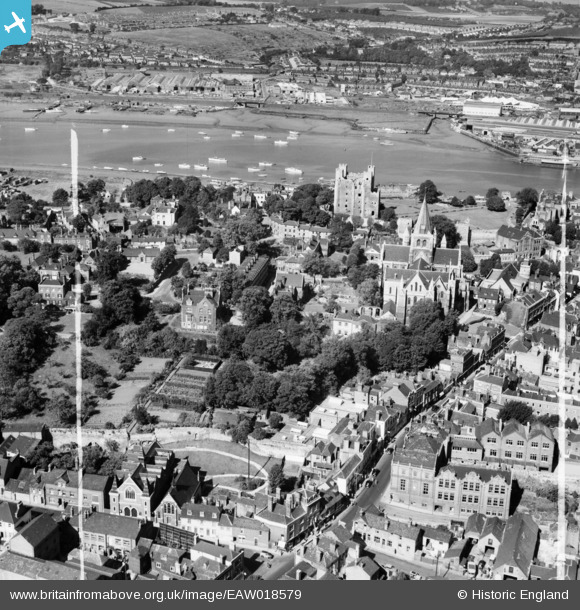
EAW018579 ENGLAND (1948). Rochester City Walls, the High Street, Cathedral and Castle, Rochester, 1948. This image was marked by Aerofilms Ltd for photo editing.
© Copyright OpenStreetMap contributors and licensed by the OpenStreetMap Foundation. 2025. Cartography is licensed as CC BY-SA.
Nearby Images (25)
EAW018579

EAW003542

EAW004796

EAW018573

EAW018575

EAW018572

EAW018577

EAW004793

EAW003540

EAW018578

EAW004791

EAW003541

EAW004795

EAW017035

EAW017033

EAW003543

EAW004845

EAW004792

EAW018574

EAW018576

EAW004794

EAW003539

EAW017034

EAW017032
, town and the River Medway, Rochester, 1948. This image has been produced from a damaged negative.")
EAW017036

Details
| Title | [EAW018579] Rochester City Walls, the High Street, Cathedral and Castle, Rochester, 1948. This image was marked by Aerofilms Ltd for photo editing. |
| Reference | EAW018579 |
| Date | 9-September-1948 |
| Link | |
| Place name | ROCHESTER |
| Parish | |
| District | |
| Country | ENGLAND |
| Easting / Northing | 574261, 168456 |
| Longitude / Latitude | 0.5047793210032, 51.387855987838 |
| National Grid Reference | TQ743685 |
Pins
 TheCreteFleet |
Tuesday 12th of March 2024 08:24:50 PM | |
TheCreteFleet |
Tuesday 12th of March 2024 08:23:57 PM | |
 JohnC |
Thursday 15th of October 2015 03:13:46 PM | |
cptpies |
Monday 30th of March 2015 01:54:08 PM | |
cptpies |
Monday 30th of March 2015 01:53:37 PM |
User Comment Contributions
 Air raid shelters and camouflaged workshops, Rochester. |
cptpies |
Monday 30th of March 2015 01:55:36 PM |