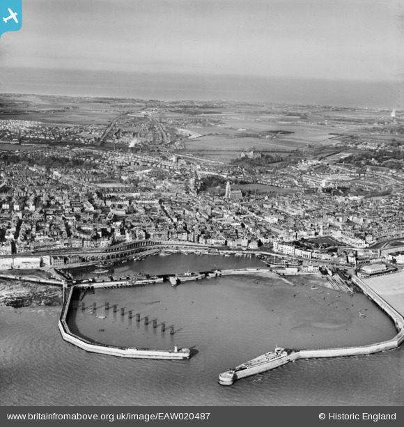
EAW020487 ENGLAND (1948). The town and harbour, Ramsgate, from the south-east, 1948
© Copyright OpenStreetMap contributors and licensed by the OpenStreetMap Foundation. 2025. Cartography is licensed as CC BY-SA.
Nearby Images (31)
Details
| Title | [EAW020487] The town and harbour, Ramsgate, from the south-east, 1948 |
| Reference | EAW020487 |
| Date | 9-November-1948 |
| Link | |
| Place name | RAMSGATE |
| Parish | RAMSGATE |
| District | |
| Country | ENGLAND |
| Easting / Northing | 638423, 164427 |
| Longitude / Latitude | 1.422795105884, 51.328370329222 |
| National Grid Reference | TR384644 |
Pins
 Post-war prefabs |
Wednesday 13th of November 2019 12:42:23 PM | |
 Alan McFaden |
Sunday 13th of July 2014 09:37:00 AM | |
 Alan McFaden |
Sunday 13th of July 2014 09:36:20 AM | |
 Alan McFaden |
Sunday 13th of July 2014 09:35:42 AM | |
 Alan McFaden |
Sunday 13th of July 2014 09:35:04 AM | |
 Alan McFaden |
Sunday 13th of July 2014 09:34:23 AM | |
 Alan McFaden |
Sunday 13th of July 2014 09:33:59 AM |


![[EAW020487] The town and harbour, Ramsgate, from the south-east, 1948](http://britainfromabove.org.uk/sites/all/libraries/aerofilms-images/public/100x100/EAW/020/EAW020487.jpg)
![[EPW039354] The Royal Harbour and Basin, Ramsgate, 1932](http://britainfromabove.org.uk/sites/all/libraries/aerofilms-images/public/100x100/EPW/039/EPW039354.jpg)
![[EAW009009] Royal Harbour and the town, Ramsgate, 1947](http://britainfromabove.org.uk/sites/all/libraries/aerofilms-images/public/100x100/EAW/009/EAW009009.jpg)
![[EAW009008] Royal Harbour and the town, Ramsgate, 1947](http://britainfromabove.org.uk/sites/all/libraries/aerofilms-images/public/100x100/EAW/009/EAW009008.jpg)
![[EAW009010] Royal Harbour and the town, Ramsgate, 1947](http://britainfromabove.org.uk/sites/all/libraries/aerofilms-images/public/100x100/EAW/009/EAW009010.jpg)
![[EAW009007] Royal Harbour and the town, Ramsgate, 1947](http://britainfromabove.org.uk/sites/all/libraries/aerofilms-images/public/100x100/EAW/009/EAW009007.jpg)
![[EAW008999] Royal Harbour and the town, Ramsgate, 1947](http://britainfromabove.org.uk/sites/all/libraries/aerofilms-images/public/100x100/EAW/008/EAW008999.jpg)
![[EPW000375] Ramsgate Harbour, Ramsgate, 1920](http://britainfromabove.org.uk/sites/all/libraries/aerofilms-images/public/100x100/EPW/000/EPW000375.jpg)
![[EAW009006] Royal Harbour and the town, Ramsgate, 1947](http://britainfromabove.org.uk/sites/all/libraries/aerofilms-images/public/100x100/EAW/009/EAW009006.jpg)
![[EPW000380] Ramsgate Harbour, Kent, 1920](http://britainfromabove.org.uk/sites/all/libraries/aerofilms-images/public/100x100/EPW/000/EPW000380.jpg)
![[EPW042862] The Royal Harbour and the town, Ramsgate, from the south, 1933](http://britainfromabove.org.uk/sites/all/libraries/aerofilms-images/public/100x100/EPW/042/EPW042862.jpg)
![[EPW018650] The Royal Harbour and basin, Ramsgate, 1927](http://britainfromabove.org.uk/sites/all/libraries/aerofilms-images/public/100x100/EPW/018/EPW018650.jpg)
![[EAW017589] The Royal Harbour and part of the town, Ramsgate, 1948. This image has been produced from a print.](http://britainfromabove.org.uk/sites/all/libraries/aerofilms-images/public/100x100/EAW/017/EAW017589.jpg)
![[EPW000595] The Royal Harbour, Ramsgate, from the south-west, 1920](http://britainfromabove.org.uk/sites/all/libraries/aerofilms-images/public/100x100/EPW/000/EPW000595.jpg)
![[EPW000091] Royal Harbour, Ramsgate, 1920](http://britainfromabove.org.uk/sites/all/libraries/aerofilms-images/public/100x100/EPW/000/EPW000091.jpg)
![[EPW000598] The Basin and Royal Harbour, Ramsgate, 1920](http://britainfromabove.org.uk/sites/all/libraries/aerofilms-images/public/100x100/EPW/000/EPW000598.jpg)
![[EAW017592] The Royal Harbour and town, Ramsgate, from the south, 1948. This image has been produced from a print.](http://britainfromabove.org.uk/sites/all/libraries/aerofilms-images/public/100x100/EAW/017/EAW017592.jpg)
![[EAW020488] The town and harbour, Ramsgate, from the south-west, 1948](http://britainfromabove.org.uk/sites/all/libraries/aerofilms-images/public/100x100/EAW/020/EAW020488.jpg)
![[EPW018653] The Royal Harbour, basin and environs, Ramsgate, 1927](http://britainfromabove.org.uk/sites/all/libraries/aerofilms-images/public/100x100/EPW/018/EPW018653.jpg)
![[EPW035449] The Royal Harbour and environs, Ramsgate, 1931](http://britainfromabove.org.uk/sites/all/libraries/aerofilms-images/public/100x100/EPW/035/EPW035449.jpg)
![[EPW048858] The Royal Harbour, Ramsgate, 1935](http://britainfromabove.org.uk/sites/all/libraries/aerofilms-images/public/100x100/EPW/048/EPW048858.jpg)
![[EAW008997] Royal Harbour and the town, Ramsgate, from the south, 1947](http://britainfromabove.org.uk/sites/all/libraries/aerofilms-images/public/100x100/EAW/008/EAW008997.jpg)
![[EAW008998] Royal Harbour and the town, Ramsgate, from the south, 1947](http://britainfromabove.org.uk/sites/all/libraries/aerofilms-images/public/100x100/EAW/008/EAW008998.jpg)
![[EAW015836] Royal Harbour, Ramsgate, 1948. This image has been produced from a print.](http://britainfromabove.org.uk/sites/all/libraries/aerofilms-images/public/100x100/EAW/015/EAW015836.jpg)
![[EAW020486] The town and harbour, Ramsgate, from the east, 1948](http://britainfromabove.org.uk/sites/all/libraries/aerofilms-images/public/100x100/EAW/020/EAW020486.jpg)
![[EPW000600] The Royal Harbour and The Basin, Ramsgate, 1920](http://britainfromabove.org.uk/sites/all/libraries/aerofilms-images/public/100x100/EPW/000/EPW000600.jpg)
![[EAW696658] Western Ferry Terminal, Ramsgate, 2003](http://britainfromabove.org.uk/sites/all/libraries/aerofilms-images/public/100x100/EAW/696/EAW696658.jpg)
![[EAW009050] East Pier, Ramsgate Sands and the town, Ramsgate, 1947](http://britainfromabove.org.uk/sites/all/libraries/aerofilms-images/public/100x100/EAW/009/EAW009050.jpg)
![[EPW018646] The Royal Harbour and Harbour Parade, Ramsgate, 1927](http://britainfromabove.org.uk/sites/all/libraries/aerofilms-images/public/100x100/EPW/018/EPW018646.jpg)
![[EPW000596] The Royal Harbour, Ramsgate, 1920](http://britainfromabove.org.uk/sites/all/libraries/aerofilms-images/public/100x100/EPW/000/EPW000596.jpg)
![[EPW039353] Ramsgate Sands, Wellington Crescent and environs, Ramsgate, from the south, 1932](http://britainfromabove.org.uk/sites/all/libraries/aerofilms-images/public/100x100/EPW/039/EPW039353.jpg)


