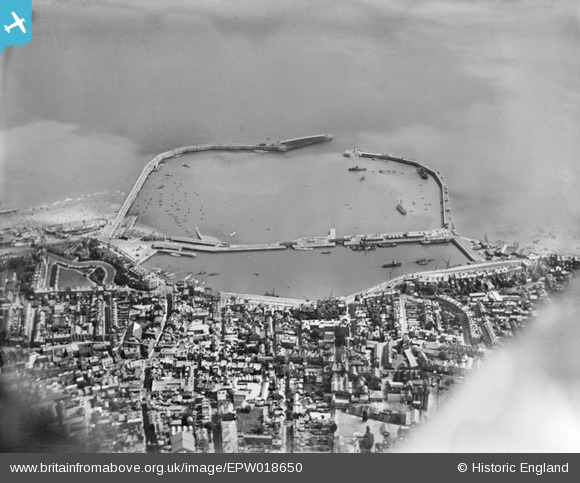
EPW018650 ENGLAND (1927). The Royal Harbour and basin, Ramsgate, 1927
© Copyright OpenStreetMap contributors and licensed by the OpenStreetMap Foundation. 2025. Cartography is licensed as CC BY-SA.
Nearby Images (29)
Details
| Title | [EPW018650] The Royal Harbour and basin, Ramsgate, 1927 |
| Reference | EPW018650 |
| Date | 22-June-1927 |
| Link | |
| Place name | RAMSGATE |
| Parish | RAMSGATE |
| District | |
| Country | ENGLAND |
| Easting / Northing | 638383, 164580 |
| Longitude / Latitude | 1.4223243239524, 51.329760532671 |
| National Grid Reference | TR384646 |
Pins
 Alan McFaden |
Sunday 13th of July 2014 11:56:44 AM | |
 Alan McFaden |
Sunday 13th of July 2014 11:56:00 AM | |
 Alan McFaden |
Sunday 13th of July 2014 11:55:15 AM | |
 Alan McFaden |
Sunday 13th of July 2014 11:54:13 AM |


![[EPW018650] The Royal Harbour and basin, Ramsgate, 1927](http://britainfromabove.org.uk/sites/all/libraries/aerofilms-images/public/100x100/EPW/018/EPW018650.jpg)
![[EAW009006] Royal Harbour and the town, Ramsgate, 1947](http://britainfromabove.org.uk/sites/all/libraries/aerofilms-images/public/100x100/EAW/009/EAW009006.jpg)
![[EAW009007] Royal Harbour and the town, Ramsgate, 1947](http://britainfromabove.org.uk/sites/all/libraries/aerofilms-images/public/100x100/EAW/009/EAW009007.jpg)
![[EAW017592] The Royal Harbour and town, Ramsgate, from the south, 1948. This image has been produced from a print.](http://britainfromabove.org.uk/sites/all/libraries/aerofilms-images/public/100x100/EAW/017/EAW017592.jpg)
![[EAW009009] Royal Harbour and the town, Ramsgate, 1947](http://britainfromabove.org.uk/sites/all/libraries/aerofilms-images/public/100x100/EAW/009/EAW009009.jpg)
![[EPW018653] The Royal Harbour, basin and environs, Ramsgate, 1927](http://britainfromabove.org.uk/sites/all/libraries/aerofilms-images/public/100x100/EPW/018/EPW018653.jpg)
![[EPW000091] Royal Harbour, Ramsgate, 1920](http://britainfromabove.org.uk/sites/all/libraries/aerofilms-images/public/100x100/EPW/000/EPW000091.jpg)
![[EAW009008] Royal Harbour and the town, Ramsgate, 1947](http://britainfromabove.org.uk/sites/all/libraries/aerofilms-images/public/100x100/EAW/009/EAW009008.jpg)
![[EPW039354] The Royal Harbour and Basin, Ramsgate, 1932](http://britainfromabove.org.uk/sites/all/libraries/aerofilms-images/public/100x100/EPW/039/EPW039354.jpg)
![[EPW000598] The Basin and Royal Harbour, Ramsgate, 1920](http://britainfromabove.org.uk/sites/all/libraries/aerofilms-images/public/100x100/EPW/000/EPW000598.jpg)
![[EAW015835] The town and seafront, Ramsgate, 1948. This image has been produced from a print.](http://britainfromabove.org.uk/sites/all/libraries/aerofilms-images/public/100x100/EAW/015/EAW015835.jpg)
![[EAW015836] Royal Harbour, Ramsgate, 1948. This image has been produced from a print.](http://britainfromabove.org.uk/sites/all/libraries/aerofilms-images/public/100x100/EAW/015/EAW015836.jpg)
![[EAW009010] Royal Harbour and the town, Ramsgate, 1947](http://britainfromabove.org.uk/sites/all/libraries/aerofilms-images/public/100x100/EAW/009/EAW009010.jpg)
![[EPW035449] The Royal Harbour and environs, Ramsgate, 1931](http://britainfromabove.org.uk/sites/all/libraries/aerofilms-images/public/100x100/EPW/035/EPW035449.jpg)
![[EAW020487] The town and harbour, Ramsgate, from the south-east, 1948](http://britainfromabove.org.uk/sites/all/libraries/aerofilms-images/public/100x100/EAW/020/EAW020487.jpg)
![[EAW006165] The Basin, Harbour Parade and environs, Ramsgate, 1947](http://britainfromabove.org.uk/sites/all/libraries/aerofilms-images/public/100x100/EAW/006/EAW006165.jpg)
![[EPW000092] The Clock Tower, Ramsgate Harbour, Ramsgate 1920](http://britainfromabove.org.uk/sites/all/libraries/aerofilms-images/public/100x100/EPW/000/EPW000092.jpg)
![[EAW006164] The Basin, Harbour Parade and environs, Ramsgate, 1947](http://britainfromabove.org.uk/sites/all/libraries/aerofilms-images/public/100x100/EAW/006/EAW006164.jpg)
![[EPW000604] The Basin, Ramsgate, from the north-east, 1920](http://britainfromabove.org.uk/sites/all/libraries/aerofilms-images/public/100x100/EPW/000/EPW000604.jpg)
![[EPW000096] Ramsgate Basin, Ramsgate, 1920](http://britainfromabove.org.uk/sites/all/libraries/aerofilms-images/public/100x100/EPW/000/EPW000096.jpg)
![[EAW017589] The Royal Harbour and part of the town, Ramsgate, 1948. This image has been produced from a print.](http://britainfromabove.org.uk/sites/all/libraries/aerofilms-images/public/100x100/EAW/017/EAW017589.jpg)
![[EAW008999] Royal Harbour and the town, Ramsgate, 1947](http://britainfromabove.org.uk/sites/all/libraries/aerofilms-images/public/100x100/EAW/008/EAW008999.jpg)
![[EPW042864] The Royal Harbour and the town, Ramsgate, 1933](http://britainfromabove.org.uk/sites/all/libraries/aerofilms-images/public/100x100/EPW/042/EPW042864.jpg)
![[EPW000596] The Royal Harbour, Ramsgate, 1920](http://britainfromabove.org.uk/sites/all/libraries/aerofilms-images/public/100x100/EPW/000/EPW000596.jpg)
![[EAW020488] The town and harbour, Ramsgate, from the south-west, 1948](http://britainfromabove.org.uk/sites/all/libraries/aerofilms-images/public/100x100/EAW/020/EAW020488.jpg)
![[EPW039324] The Royal Victoria Pavilion, Ramsgate, 1932](http://britainfromabove.org.uk/sites/all/libraries/aerofilms-images/public/100x100/EPW/039/EPW039324.jpg)
![[EAW009051] Crowds at the Royal Victoria Pavilion and Ramsgate Sands, Ramsgate, 1947](http://britainfromabove.org.uk/sites/all/libraries/aerofilms-images/public/100x100/EAW/009/EAW009051.jpg)
![[EAW696658] Western Ferry Terminal, Ramsgate, 2003](http://britainfromabove.org.uk/sites/all/libraries/aerofilms-images/public/100x100/EAW/696/EAW696658.jpg)
![[EAW024843] The Royal Victoria Pavilion and environs, Ramsgate, 1949](http://britainfromabove.org.uk/sites/all/libraries/aerofilms-images/public/100x100/EAW/024/EAW024843.jpg)


