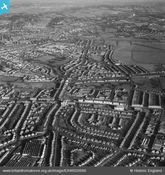
EAW020696 ENGLAND (1948). Burnt Oak and the northern end of RAF Hendon, Edgware, from the south-west, 1948
© Copyright OpenStreetMap contributors and licensed by the OpenStreetMap Foundation. 2025. Cartography is licensed as CC BY-SA.
Nearby Images (15)
Details
| Title | [EAW020696] Burnt Oak and the northern end of RAF Hendon, Edgware, from the south-west, 1948 |
| Reference | EAW020696 |
| Date | 17-December-1948 |
| Link | |
| Place name | EDGWARE |
| Parish | |
| District | |
| Country | ENGLAND |
| Easting / Northing | 520195, 190393 |
| Longitude / Latitude | -0.26440951753663, 51.599066279788 |
| National Grid Reference | TQ202904 |
Pins
 Moderne |
Tuesday 18th of April 2023 12:13:26 PM | |
 redmist |
Wednesday 27th of March 2019 07:01:39 PM | |
 ken |
Monday 15th of June 2015 05:37:21 PM | |
 ken |
Monday 15th of June 2015 05:36:19 PM | |
 clive |
Friday 5th of December 2014 01:34:08 AM | |
 colsouth111 |
Saturday 13th of September 2014 11:37:18 AM | |
 colsouth111 |
Saturday 13th of September 2014 11:36:00 AM | |
 colsouth111 |
Saturday 13th of September 2014 11:33:36 AM | |
 colsouth111 |
Saturday 13th of September 2014 11:33:08 AM | |
 colsouth111 |
Saturday 13th of September 2014 11:31:51 AM | |
 colsouth111 |
Saturday 13th of September 2014 11:30:59 AM | |
 SB83 |
Monday 24th of February 2014 03:47:35 PM | |
 SB83 |
Monday 24th of February 2014 03:47:09 PM | |
 bazouteast |
Wednesday 19th of February 2014 08:29:04 PM | |
 bazouteast |
Wednesday 19th of February 2014 08:26:21 PM | |
 bazouteast |
Wednesday 19th of February 2014 08:25:21 PM | |
 bazouteast |
Wednesday 19th of February 2014 08:24:13 PM | |
 colsouth111 |
Monday 27th of January 2014 07:04:34 PM | |
 colsouth111 |
Monday 27th of January 2014 07:03:55 PM | |
 colsouth111 |
Monday 27th of January 2014 07:03:06 PM | |
 colsouth111 |
Monday 27th of January 2014 07:02:38 PM | |
 colsouth111 |
Monday 27th of January 2014 07:02:00 PM | |
 colsouth111 |
Monday 27th of January 2014 07:00:58 PM | |
 colsouth111 |
Monday 27th of January 2014 06:57:33 PM | |
 colsouth111 |
Monday 27th of January 2014 06:56:21 PM | |
 colsouth111 |
Monday 27th of January 2014 06:54:17 PM | |
 colsouth111 |
Monday 27th of January 2014 06:50:48 PM |
User Comment Contributions
Now we can see Burnt Oak as I remember it, dominated by the rather grand London Co-op built in 1936, at the top of Stag Lane. I remember also the Fifty Shilling Tailor, already a rather optimistic name by 1948, Hemmings the bakers, the Express Dairy at the corner of the Watling, John Ford, a traditional Sainsbury's, ABC bakers and tea room, and of course Sidney Hurry, what a name for an undertaker! One year the 50 bob tailor (by then called John Collier) rather foolishly put it's sale posters on the outside of it's windows. Needless to say they soon found their way on to the undertakers window! |
 colsouth111 |
Wednesday 29th of January 2014 03:17:58 PM |
Hi colsouth111, It's really interesting to read your comments on the photos for this area. Growing up near enough to be familiar with the Stanmore-Kingsbury run (Jubilee line was the nearest access point for the tube network), I've found it very instructive to catalogue the air photos around the Edgware Road! Yours, Katy Britain from Above Cataloguing Team Leader |
Katy Whitaker |
Wednesday 29th of January 2014 03:17:58 PM |


![[EAW020696] Burnt Oak and the northern end of RAF Hendon, Edgware, from the south-west, 1948](http://britainfromabove.org.uk/sites/all/libraries/aerofilms-images/public/100x100/EAW/020/EAW020696.jpg)
![[EPW017587] New housing beside the Edgware Road, Burnt Oak, from the south-east, 1927](http://britainfromabove.org.uk/sites/all/libraries/aerofilms-images/public/100x100/EPW/017/EPW017587.jpg)
![[EPW017379] Housing estates under construction along Edgware Road, Burnt Oak, 1927](http://britainfromabove.org.uk/sites/all/libraries/aerofilms-images/public/100x100/EPW/017/EPW017379.jpg)
![[EPW019190] Watling Avenue, Burnt Oak, 1927](http://britainfromabove.org.uk/sites/all/libraries/aerofilms-images/public/100x100/EPW/019/EPW019190.jpg)
![[EPW017580] New housing beside the Edgware Road, Burnt Oak, from the south-east, 1927](http://britainfromabove.org.uk/sites/all/libraries/aerofilms-images/public/100x100/EPW/017/EPW017580.jpg)
![[EPW017584] Argyll Gardens and Kenmore Gardens under construction, Little Stanmore, 1927](http://britainfromabove.org.uk/sites/all/libraries/aerofilms-images/public/100x100/EPW/017/EPW017584.jpg)
![[EPW017582] New housing beside the Edgware Road, Burnt Oak, from the south-east, 1927](http://britainfromabove.org.uk/sites/all/libraries/aerofilms-images/public/100x100/EPW/017/EPW017582.jpg)
![[EPW019191] Barnfield Road, Burnt Oak, 1927](http://britainfromabove.org.uk/sites/all/libraries/aerofilms-images/public/100x100/EPW/019/EPW019191.jpg)
![[EPW017380] Housing estates under construction along Edgware Road, Burnt Oak, 1927](http://britainfromabove.org.uk/sites/all/libraries/aerofilms-images/public/100x100/EPW/017/EPW017380.jpg)
![[EPW018768] Construction of the Watling Estate, Edgware, 1927](http://britainfromabove.org.uk/sites/all/libraries/aerofilms-images/public/100x100/EPW/018/EPW018768.jpg)
![[EPW017583] Stag Lane, Queensbury, 1927](http://britainfromabove.org.uk/sites/all/libraries/aerofilms-images/public/100x100/EPW/017/EPW017583.jpg)
![[EPW017378] Housing estates under construction along Edgware Road, Burnt Oak, 1927](http://britainfromabove.org.uk/sites/all/libraries/aerofilms-images/public/100x100/EPW/017/EPW017378.jpg)
![[EPW018769] Construction of the Watling Estate, Edgware, 1927](http://britainfromabove.org.uk/sites/all/libraries/aerofilms-images/public/100x100/EPW/018/EPW018769.jpg)
![[EPW018766] Construction of the Watling Estate, Edgware, 1927](http://britainfromabove.org.uk/sites/all/libraries/aerofilms-images/public/100x100/EPW/018/EPW018766.jpg)
![[EPW019193] Barnfield Road and the Redhill Institution, Burnt Oak, 1927](http://britainfromabove.org.uk/sites/all/libraries/aerofilms-images/public/100x100/EPW/019/EPW019193.jpg)
